
Everest
Description
- Height 8848.00 m
The world's absolute highest mountain, located on the border between Tibet, China and Nepal.
Links
Facts
Reports
Guides and maps
Lodging
Organisations
Tour operators
GPS
Other
Books

The Book Depository
United Kingdom
United Kingdom
- Trekking Everest Base Camp - The Day to Day Guide
- and what isn't in the guidebooks Read more


The Book Depository
United Kingdom
United Kingdom
- The Girl Who Climbed Everest
- The Inspirational of Alyssa Azar, Australia's Youngest Adventurer Read more

The Book Depository
United Kingdom
United Kingdom
- A Trekking Guide to Everest
- Everest Base Camp, Gokyo Lakes, Thame Valley, Three High Passes, Classic Everest, Arun Valley Read more

The Book Depository
United Kingdom
United Kingdom
- The Girl Who Climbed Everest
- The Inspirational of Alyssa Azar, Australia's Youngest Adventurer Read more


The Book Depository
United Kingdom
United Kingdom
- Doofus Dad Does Everest Base Camp
- One of Planet Earth's epic adventures told by a slightly-less-than-epic guy Read more


Stanfords
United Kingdom
United Kingdom
- Everest England
- A unique hill-walking guide with a culminative ascent of the height of Everest, written in Peter Owen Jones` unique descriptive style. Scaling the peaks of Everest, the world`s highest mountain, is the ultimate physical and mental challenge that the human race can aspire to. But as it takes years of preparation and a minimum of £25,000 to... Read more
- Also available from:
- The Book Depository, United Kingdom


The Book Depository
United Kingdom
United Kingdom
- The Girl Who Climbed Everest: The inspirational story of Alyssa Azar, Australia's Youngest Adventurer
- The Inspirational Story of Alyssa Azar, Australia's Youngest Adventurer Read more


The Book Depository
United Kingdom
United Kingdom
- Everest Base Camp and Beyond
- The Practical Guide to Boutique Travel in Nepal Read more
Maps

Stanfords
United Kingdom
United Kingdom
- Ama Dablam
- Mt. Everest area on a contoured and GPS-compatible map at 1:40,000 from Nepa Maps, designed to show trekking routes from Namche, Tengboche and Pangboche towards the Ama Dablam and Imja Tse (Island Peak) Base Camps, and the continuation climbing routes towards these two peaks, Lhotse and Lhotse Star.With Thamo and Namche Bazar in the... Read more

Stanfords
United Kingdom
United Kingdom
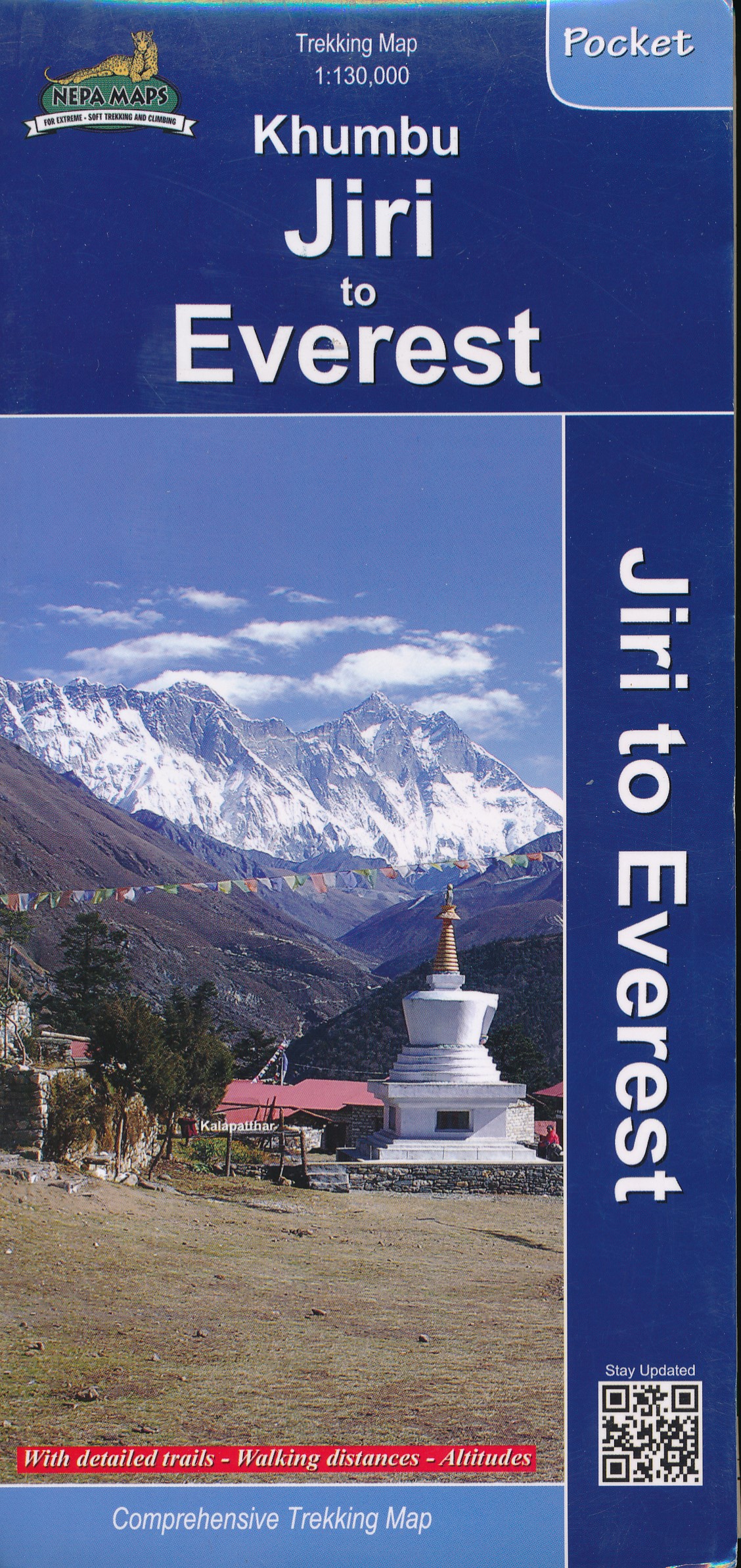
- Khumbu - Jiri to Everest Nepa Maps Trekking Map
- Trekking route from Juri to Lukla and Namche Bazaar, and then on to the Everest Base Camp presented on a map at 1:100,000 from Nepa Maps. In addition to the main trekking route from Jiri to Mt Everest the map also highlights several other routes in the Khumbu region including treks to Gokyo Lakes, Island Peak (Imja Tse), Mera Peak, Amphu Labsta... Read more

Stanfords
United Kingdom
2017
United Kingdom
2017
- Nepal Nelles
- Nepal on a waterproof and tear-resistant map from Nelles, presenting the whole country at 1:1,500,000, with its more visited central and eastern regions also shown in more detail at 1:480,000, plus enlargement of the Kathmandu Valley and the Rara Lake area and street plans of central Kathmandu City, Patan, Bhaktapur and the lakeside district of... Read more

Stanfords
United Kingdom
United Kingdom
- Solu Khumbu - Everest Region Great Himayala Trail Map
- Solu Khumbu/Everest Region, map no. 103, at 1:100,000 on a waterproof and tear-resistant trekking map from the Himalayan MapHouse in their series covering the whole of northern Nepal. The map highlights main trekking routes from Lukla, both north and south of the town: Everest Base Camp Trek, alternative routes to the Gokyo Lakes, Bhote Koshi... Read more

Stanfords
United Kingdom
United Kingdom
- Numbur Cheese Circuit
- Numbur Cheese Circuit at 1:100,000 in the Nepa Maps series which provides extensive coverage of trekking areas of Nepal on detailed contoured maps with trekking routes and hiking trails, huts and camp sites, local places of interest and other tourist information.The map covers the same area as the publishers’ “Jiri to Everest” title and has... Read more

Stanfords
United Kingdom
United Kingdom
- Everest Region Trekking Map
- Mount Everest area on a trekking map at 1:75,000 from the Kolkata/Calcutta based Milestone Books, highlighting main trekking routes and showing peaks, passes and selected locations with altitude both in metres and feet. Coverage extends from just south of Lukla to the Chinese side of Mount Everest and the peaks of Cho Oyo and Gyachung Kang.The... Read more

Stanfords
United Kingdom
United Kingdom
- Tenzing-Hillary Trek - Jiri to Everest Base Camp
- One of Nepal’s most popular trekking routes, from Juri to the Base Camp of Mount Everest, presented on a double-sided map at 1:50,000 from Nepa Maps. Now named after the two conquerors of Everest, the main trek is prominently marked on the map, along with the route from Namche Bazaar to Gokyo Lakes. Also highlighted are numerous other treks in... Read more

Stanfords
United Kingdom
United Kingdom
- Island Peak / Imja Tse Nepa Maps Climbing Map
- The trek from Namche to the base camp of the Island Peak (Imja Tse) with the climbing route to the peak itself annotated with views towards the surrounding mountains, presented by Nepa Maps at 1:40,000. The map also includes plans of Namche and Lukla highlighting accommodation and other facilities.Namche is in the south-western corner of the... Read more

Stanfords
United Kingdom
United Kingdom
- Everest - Gokyo - Cho La - the Renjo Pass (60K)
- Everest – Gokyo - Cho La - Renjo Pass map at 1:60,000 from the Himalayan MapHouse, prominently highlighting the Three Passes Trek from Lukla and Namche along a section of the Everest Trek via Tengboche and Dingboche to the Thokla Pass, then westwards to the Cho (Chhugyuma) La Pass, Gokyo Lake and the Rejno La Pass, and southwards back to Namche... Read more
Stanfords
United Kingdom
United Kingdom
- Island Peak (Imja Tse)
- The trek from Namche to the base camp of the Island Peak (Imja Tse) with the climbing route to the peak itself annotated with views towards the surrounding mountains, presented by Nepa Maps at 1:40,000. The map also includes plans of Namche and Lukla highlighting accommodation and other facilities.Namche is in the south-western corner of the... Read more

Stanfords
United Kingdom
United Kingdom
- Mt. Everest (Sagarmatha) - Hinku Himal
- Mount Everesr (Sagarmatha) - Hinku Himal, sheet no. 2786-04, in the topographic survey of Nepal at 1:50,000 published by the Nepali Government in the late 1990s and early 2000s and produced from remote sensing data by Finnish cartographers as part of that country’s international aid program. The maps cover 15’ x 15’ quadrangles.IMPORTANT –... Read more

Stanfords
United Kingdom
United Kingdom
- Everest - Trekking Map & Complete Guide
- Everest Trekking Guide from Milestone Books with very detailed and informative stage-by-stage descriptions of main Mt Everest trek from Lukla and Namche Bazaar to the Everest Base Camp, plus the route to the Gokyo Lakes. Each route is presented on coloured map extracts from the accompanying separate fold-out map, includes a route profile, and... Read more
- Also available from:
- The Book Depository, United Kingdom

The Book Depository
United Kingdom
United Kingdom
- Everest: Trekking Map & Complete Guide
- Everest Trekking Guide from Milestone Books with very detailed and informative stage-by-stage descriptions of main Mt Everest trek from Lukla and Namche Bazaar to the Everest Base Camp, plus the route to the Gokyo Lakes. Each route is presented on coloured map extracts from the accompanying separate fold-out map, includes a route profile, and... Read more
De Zwerver
Netherlands
Netherlands
- Wandelkaart Khumbu - Jiri to Everest pocket map | Himalayan Maphouse
- Handige pocket map voor het hele gebied voor de Everest trek naar het Base Camp vanaf zowel Jiri als ook vanaf Phaplu of Lukla. Een beetje grove schaal, maar juist voor het overzicht een ideale kaart. Ook de trekkings in Rolwaling vind je hier op terug. Read more

Stanfords
United Kingdom
United Kingdom
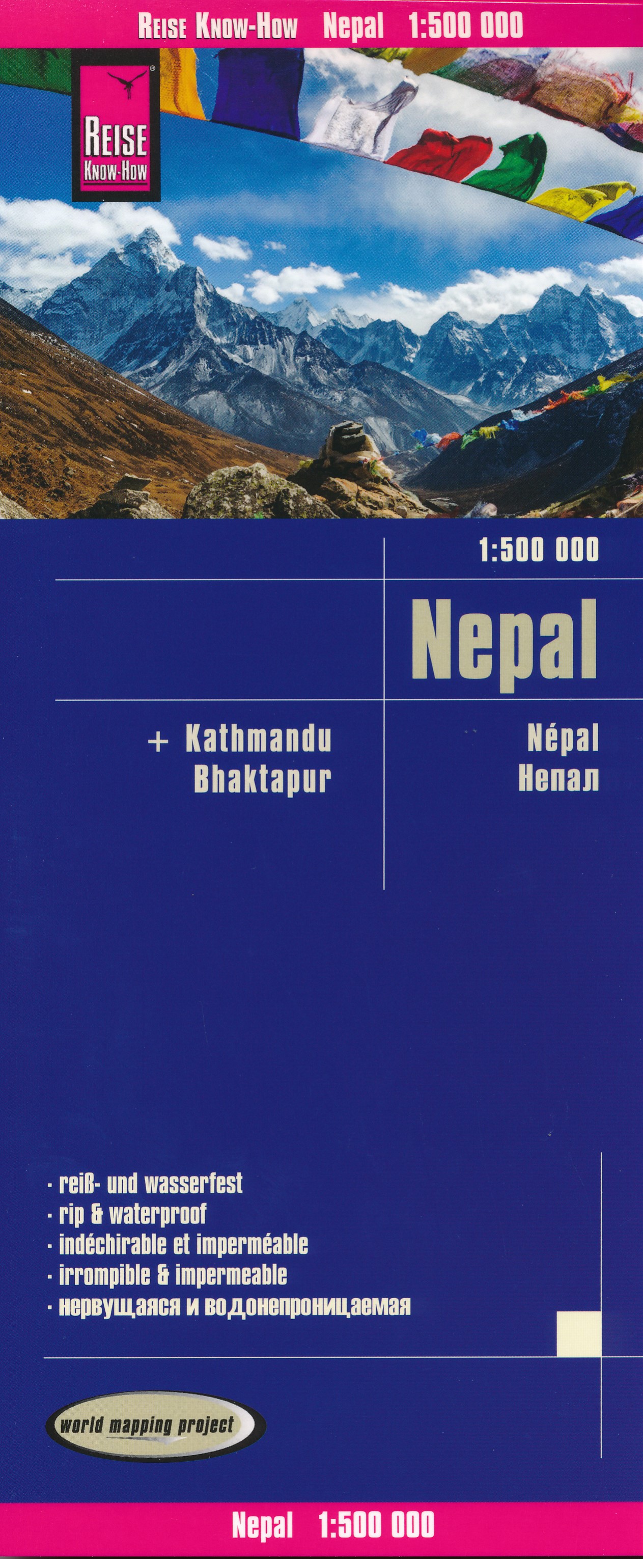
- Nepal Reise Know-How
- Nepal on an indexed, waterproof and tear-resistant road map, ideal for locating the country`s numerous famous peaks, with topographic and tourist information, and enlargements for Kathmandu, Pokhara, and Chitwan regions, plus Bhaktapur. The map, published by Reise Know-How as part of their highly acclaimed World Mapping Project, is double-sided... Read more
- Also available from:
- De Zwerver, Netherlands
De Zwerver
Netherlands
Netherlands
- Wegenkaart - landkaart Nepal | Reise Know-How Verlag
- Nepal on an indexed, waterproof and tear-resistant road map, ideal for locating the country`s numerous famous peaks, with topographic and tourist information, and enlargements for Kathmandu, Pokhara, and Chitwan regions, plus Bhaktapur. The map, published by Reise Know-How as part of their highly acclaimed World Mapping Project, is double-sided... Read more

De Zwerver
Netherlands
Netherlands
- Wandelkaart The Great Himalaya Trail | GHT
- Prachtige kaartenserie van één van 'swerelds mooiste wandeltochten. The Far West is one of the least explored areas of Nepal. Its area is bounded to the east by mighty, turquoise Karnali river which flows from Tibet’s sacred Mount Kailash. Myth and superstition remain part of the fabric of life here. Though the Nepali language originated... Read more