Wad- en Wierdenpad
Description
- Name Wad- en Wierdenpad (LAW5-5)
- Length of trail 123 km, 76 miles
- Length in days 6 days
- Start of trail Lauwersoog
- End of trail Nieuweschans
- Traildino grading LW, Light walk, countryside walk


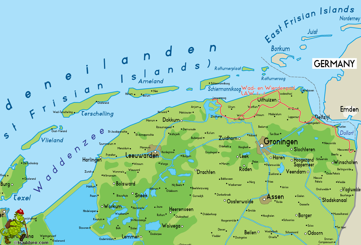
LAW5-5, Wad- en Wierdenpad: Lauwersoog - Nieuweschans, 123 km
The northern part of the Netherlands is a product of the sea. Let's explain the name of this trail, Wad- en Wierdenpad. The "wad" is the marsh area between the Frisian Islands in the North and the mainland. The transition from water to land today is clearly defined by a huge, tight dyke. The path regularly runs on this dyke, and from it we conveniently look down on modern farmlands, a bit as if we were walking on a mountain ridge. Sharp as it is today, historically, this transition from sea to land was far from clear and in constant motion. At times the sea was calm and the people conquered land from the sea. But ever so often, the sea would turn wild, and take back what people had made.
A "wierde", or mound, is an artificial elevation in the country, where former residents built their homes, churches and monasteries, protected from rising seas. These mounds are still there, and our path leads us across.
In the little villages on our way, time has truly stood still. Not that we relive the Middle Ages, but on every street corner there's the déjà vu from our own childhood, when life was simple. Moreover, everyone will greet you with a goodmorning or a goodday!
The Wad- en Wierdenpad is the last stretch of the Dutch part of the North Sea Trail. At the border in Nieuweschans, the Germans take over on the E9, the Ems-Dollart Trail. But it is also possible to head south, and continue on the LAW10, the Noaberpad. (HN)
Map
Links
Facts
Reports
Guides and maps
Lodging
Organisations
Tour operators
GPS
Other
Books

United Kingdom
- Purbeck & South Dorset - Poole, Dorchester - Weymouth & Swanage OS Explorer Active Map OL15 (waterproof)
- Purbeck and the southern part of Dorset on a detailed topographic and GPS compatible map OL15, waterproof version, from the Ordnance Survey’s 1:25,000 Explorer series. Coverage extends from Poole and Swanage in the east to Bridport in the west, and includes Dorchester, Tolpuddle, Bere Regis, Wareham, Weymouth, Chesil Beach, Portland Bill, the... Read more
- Also available from:
- The Book Depository, United Kingdom

United Kingdom
- Purbeck & South Dorset - Poole, Dorchester - Weymouth & Swanage OS Explorer Map OL15 (paper)
- Purbeck and the southern part of Dorset on a detailed topographic and GPS compatible map OL15, paper version, from the Ordnance Survey’s 1:25,000 Explorer series. Coverage extends from Poole and Swanage in the east to Bridport in the west, and includes Dorchester, Tolpuddle, Bere Regis, Wareham, Weymouth, Chesil Beach, Portland Bill, the final... Read more
- Also available from:
- The Book Depository, United Kingdom
- Bol.com, Netherlands
- Bol.com, Belgium
- De Zwerver, Netherlands

Netherlands
- Purbeck & South Dorset, Poole, Dorchester, Weymouth & Swanage
- OS Explorer is the Ordnance Survey's most detailed map and is recommended for anyone enjoying outdoor activities like walking, horse riding and off-road cycling. The OS Explorer range of OL maps now includes a digital version of the paper map, accessed through the OS smartphone app, OS Maps. Providing complete GB coverage the series details... Read more

Belgium
- Purbeck & South Dorset, Poole, Dorchester, Weymouth & Swanage
- OS Explorer is the Ordnance Survey's most detailed map and is recommended for anyone enjoying outdoor activities like walking, horse riding and off-road cycling. The OS Explorer range of OL maps now includes a digital version of the paper map, accessed through the OS smartphone app, OS Maps. Providing complete GB coverage the series details... Read more
Netherlands
- Wad- en WierdenpadL LAW 5 Lauwersoog - Nieuweschans
- Wandelen in het zeekleigebied van Noord-Groningen. Deze wandeling biedt een kennismaking met de vele karakteristieke landschapselementen die herinneren aan de omgang met het water, o.a. dijken, restanten van oude zeegeulen, wierden en sluizen. Het Noord-Groningse landschap is voor wie niet uit deze omgeving komt verrassend. Vergezichten in het... Read more
- Also available from:
- Bol.com, Belgium
Belgium
- Wad- en WierdenpadL LAW 5 Lauwersoog - Nieuweschans
- Wandelen in het zeekleigebied van Noord-Groningen. Deze wandeling biedt een kennismaking met de vele karakteristieke landschapselementen die herinneren aan de omgang met het water, o.a. dijken, restanten van oude zeegeulen, wierden en sluizen. Het Noord-Groningse landschap is voor wie niet uit deze omgeving komt verrassend. Vergezichten in het... Read more


