
Peak District
Description
Beloved region in Central England. The Peak District - wild hills and friendly valleys - attracts many walkers from the nearby population centres and beyond. Best known trail is the Pennine Way. The Peak District in fact marks the southern end of the Pennines.
Trails in this region
Links
Facts
Reports
Guides and maps
Lodging
Organisations
Tour operators
GPS
Other
Books

Stanfords
United Kingdom
United Kingdom
- Camra`s Lake District Pub Walks
- This is a pocket-sized, traveller`s guide to some of the best walking and best pubs in the Lake District. The walks are grouped geographically around tourist hubs with plenty of accommodation, making the book ideal for a visitor to the Lakes. ”Lake District Pub Walks” also explores some of the region`s fascinating historical and literary... Read more

Stanfords
United Kingdom
United Kingdom
- Railway Walks: LMS
- Jeff Vinter, consultant to the BBC`s popular ”Railway Walks” series, here provides a detailed guide to ten of the best railway walks in the territory of the former London Midland and Scottish Railway. These range from the Midland Railway`s express line through the Peak District to the incredible Cromford and High Peak Railway, built before... Read more

Stanfords
United Kingdom
United Kingdom
- Peak District Pub Walks
- Peak District Pub Walks is a pocket-sized, traveller`s guide to some of the best walking and best pubs in the Peak District. The book also explores some of the region`s fascinating industrial heritage and has useful information about local transport and accommodation. Featuring a variety of hill and town walks throughout this famous area of... Read more

Stanfords
United Kingdom
United Kingdom
- Peak District - Teashop Walks
- 20 circular walks based on good local teashops. Read more

Stanfords
United Kingdom
United Kingdom
- The Peak District - Kiddiwalks
- Here is a book of twenty safe walks devised with active children in mind. Packed with fun things to see and do, each circular route offers a great outing. Read more

Stanfords
United Kingdom
United Kingdom
- Wild Pub Walks
- Join the author on 30 walks in beautiful remote or mountain landscapes, each with a great pub - often with historical significance - at journey`s end. The book is aimed at the large market of hill walkers who enjoy long days out followed by a great pint in a great pub.The areas covered are: Peak District; Lake District; Highlands/Islands;... Read more

Stanfords
United Kingdom
United Kingdom
- 100 Walks in Staffordshire
- Staffordshire offers a wide range of delights for the walker - from the windswept Peak District through riverside walks to picturesque villages. This collection of 100 walks ranges from between three to eleven miles in length, with routes to suit all walking abilities. Full-colour mapping is included which is sourced from the Ordnance Survey. Read more

Stanfords
United Kingdom
2019
United Kingdom
2019
- Pennine Way: Edale to Kirk Yetholm
- Britain`s best-known National Trail winds for 256 miles through three National Parks - the Peak District, Yorkshire Dales and Northumberland. This is the 5th edition. This superb footpath showcases Britain`s finest upland scenery, while touching the literary landscape of the Bronte family and Roman history along Hadrian`s Wall. *138 large-scale... Read more

Stanfords
United Kingdom
United Kingdom
- DK Eyewitness Great Britain
- Discover Great Britain - a beautiful land rich in culture and history. Whether you want to go wild swimming in the Fairy Pools of Skye, take a windswept walk along the Jurassic Coast, or scale the heights of Snowdonia, your DK Eyewitness travel guide makes sure you experience all that Great Britain has to offer.From the jagged peaks of the... Read more

Stanfords
United Kingdom
United Kingdom
- Peak District - Waterside Walks
- 20 circular walks based on the local waterways of the Peak District, including the rivers Derwent, Wye and Dove, Macclesfield Canal and the Broomhead, Woodhead and Ladybower reservoirs. Read more

Stanfords
United Kingdom
United Kingdom
- Cambridge, Newmarket & Saffron Walden OS Landranger Active Map 154 (waterproof)
- Parts of Cambridgeshire, Suffolk and Essex with Cambridge, Newmarket and Saffron Walden, including part of the E2 European Long-distance path, on a waterproof and tear-resistant OS Active version of map No. 154 from the Ordnance Survey’s Landranger series at 1:50,000, with contoured and GPS compatible topographic mapping plus tourist... Read more

Stanfords
United Kingdom
United Kingdom
- Bury St Edmunds, Sudbury & Stowmarket OS Landranger Active Map 155 (waterproof)
- Suffolk around Bury St Edmunds, Sudbury and Stowmarket, including part of the E2 European Long-distance path, on a waterproof and tear-resistant OS Active version of map No. 155 from the Ordnance Survey’s Landranger series at 1:50,000, with contoured and GPS compatible topographic mapping plus tourist information.MOBILE DOWNLOADS: As well as... Read more

Stanfords
United Kingdom
United Kingdom
- Maidstone, Royal Tunbridge Wells, Sevenoaks & Tonbridge OS Landranger Active Map 188 (waterproof)
- Maidstone, Tunbridge Wells and the High Weald area, including a section of the North Downs Way / E2 European Long-distance Path, on a waterproof and tear-resistant OS Active version of map No. 188 from the Ordnance Survey’s Landranger series at 1:50,000, with contoured and GPS compatible topographic mapping plus tourist information.MOBILE... Read more

Stanfords
United Kingdom
United Kingdom
- North York Moors Western OS Explorer Active Map OL26 (waterproof)
- The western part of the North York Moors National Park on a detailed topographic and GPS compatible map OL26, waterproof version, from the Ordnance Survey’s 1:25,000 Explorer series. Coverage extends from Ampleforth in the south northwards to Saltburn-by-the-Sea, and from Ingleby Arncliffe to Danby, Castleton and Hutton-le-Hole, and includes... Read more

Stanfords
United Kingdom
United Kingdom
- Cheltenham, Cirencester & Stow-on-the-Wold OS Landranger Active Map 163 (waterproof)
- Cheltenham and Cirencester area, including sections of the Thames Path, the Cotswold Way and the E2 European Long-distance Path, on a waterproof and tear-resistant OS Active version of map No. 163 from the Ordnance Survey’s Landranger series at 1:50,000, with contoured and GPS compatible topographic mapping plus tourist information.MOBILE... Read more
Maps

Stanfords
United Kingdom
United Kingdom
- Berwick-upon-Tweed 1926
- Map No. 75, Berwick-upon-Tweed 1926, in the Cassini Historical Series of old Ordnance Survey mapping of England and Wales at 1:50,000 in a format designed to offer a convenient comparison with the present day coverage from the OS, and most locations in three different editions. Old historical maps have been combined so that the sheet lines... Read more
Stanfords
United Kingdom
United Kingdom
- Berwick-upon-Tweed 1901
- Map No. 75, Berwick-upon-Tweed 1901, in the Cassini Historical Series of old Ordnance Survey mapping of England and Wales at 1:50,000 in a format designed to offer a convenient comparison with the present day coverage from the OS, and most locations in three different editions. Old historical maps have been combined so that the sheet lines... Read more

Stanfords
United Kingdom
United Kingdom
- Peak District - Dark Peak A-Z Adventure Atlas
- Peak District: Dark Peak Adventure Atlas at 1:25,000 in a series of handy A5 size Adventure Atlases from Geographers` A-Z Map Company with cartography from the Ordnance Survey’s Explorer series. Coverage includes Glossop, Hadfield, Stocksbridge, Chapel-en-le-Frith, Hope, Bamford, New Mills, Castleton, Bradwell, Hayfield, Tintwistle, Greenfield,... Read more
Stanfords
United Kingdom
United Kingdom
- Haltwhistle and Brampton 1866-1925 (3-map set)
- Map No. 86, Haltwhistle and Brampton 1866-1925 (3-map set), in the Cassini Historical Series of old Ordnance Survey mapping of England and Wales at 1:50,000 in a format designed to offer a convenient comparison with the present day coverage from the OS, and most locations in three different editions. Old historical maps have been combined so... Read more
Stanfords
United Kingdom
United Kingdom
- Buxton and Matlock 1902-1903
- Map No. 119, Buxton and Matlock 1902-1903, in the Cassini Historical Series of old Ordnance Survey mapping of England and Wales at 1:50,000 in a format designed to offer a convenient comparison with the present day coverage from the OS, and most locations in three different editions. Old historical maps have been combined so that the sheet... Read more

Stanfords
United Kingdom
United Kingdom
- England Coast Path Adventure Map - Minehead to Brean Down
- The A-Z Adventure Series of maps combines the best of OS and A-Z, creating the perfect companion for walkers, off-road cyclists, horse riders and anyone wishing to explore the great outdoors.This official Minehead to Brean Down Adventure Map covers a 58 mile (93km) section of the England Coast Path, a new National Trail around England`s coast.... Read more
Stanfords
United Kingdom
United Kingdom
- Berwick-upon-Tweed 1865-1869
- Map No. 75, Berwick-upon-Tweed 1865-1869, in the Cassini Historical Series of old Ordnance Survey mapping of England and Wales at 1:50,000 in a format designed to offer a convenient comparison with the present day coverage from the OS, and most locations in three different editions. Old historical maps have been combined so that the sheet lines... Read more

Stanfords
United Kingdom
United Kingdom
- Pennine Bridleway: From Derbyshire through the Yorkshire Dales to Cumbria
- Pennine Bridleway is a guidebook to this National Trail taking you from Derbyshire through the Yorkshire Dales to Cumbria, following the Pennine Hills.The route is split into four sections; each section includes detailed directions as well as information on points of interest along the route, bringing the history and landscape of the trail into... Read more
Stanfords
United Kingdom
United Kingdom
- Cheviot Hills and Kielder Water 1925-1926
- Map No. 80, Cheviot Hills and Kielder Water 1925-1926, in the Cassini Historical Series of old Ordnance Survey mapping of England and Wales at 1:50,000 in a format designed to offer a convenient comparison with the present day coverage from the OS, and most locations in three different editions. Old historical maps have been combined so that... Read more
Stanfords
United Kingdom
United Kingdom
- Cheviot Hills and Kielder Water 1901
- Map No. 80, Cheviot Hills and Kielder Water 1901, in the Cassini Historical Series of old Ordnance Survey mapping of England and Wales at 1:50,000 in a format designed to offer a convenient comparison with the present day coverage from the OS, and most locations in three different editions. Old historical maps have been combined so that the... Read more
Stanfords
United Kingdom
United Kingdom
- Manchester 1842-1844
- Map No. 109, Manchester 1842-1844, in the Cassini Historical Series of old Ordnance Survey mapping of England and Wales at 1:50,000 in a format designed to offer a convenient comparison with the present day coverage from the OS, and most locations in three different editions. Old historical maps have been combined so that the sheet lines... Read more
Stanfords
United Kingdom
United Kingdom
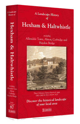
- Hexham and Haltwhistle 1863-1925 (3-map set)
- Map No. 87, Hexham and Haltwhistle 1983-1925 (3-map set), in the Cassini Historical Series of old Ordnance Survey mapping of England and Wales at 1:50,000 in a format designed to offer a convenient comparison with the present day coverage from the OS, and most locations in three different editions. Old historical maps have been combined so that... Read more
Stanfords
United Kingdom
United Kingdom
- Manchester 1903
- Map No. 109, Manchester 1903, in the Cassini Historical Series of old Ordnance Survey mapping of England and Wales at 1:50,000 in a format designed to offer a convenient comparison with the present day coverage from the OS, and most locations in three different editions. Old historical maps have been combined so that the sheet lines correspond... Read more

Stanfords
United Kingdom
United Kingdom
- Pennine Way North A-Z Adventure Atlas
- The Pennine Way North Adventure Atlas, presenting the northern section of the route between Kirk Yetholm in the Cheviot Hills and Bowes near Barnard Castle on mapping at 1:25,000 in a series of handy A5 size Adventure Atlases from Geographers` A-Z Map Company with cartography from the Ordnance Survey’s Explorer series. Coverage includes a large... Read more
Stanfords
United Kingdom
United Kingdom
- Cheviot Hills and Kielder Water 1868-1869
- Map No. 80, Cheviot Hills and Kielder Water 1868-1869, in the Cassini Historical Series of old Ordnance Survey mapping of England and Wales at 1:50,000 in a format designed to offer a convenient comparison with the present day coverage from the OS, and most locations in three different editions. Old historical maps have been combined so that... Read more