
Stanfords
United Kingdom
- Faial - Feteira - Azores 6
- Topographic survey of Portugal at 1:25,000 from the Instituto Geográfico do Exército, the country’s military survey organisation.Map legend and a glossary of terms used on the maps include English.To see all the titles in this series please click on the series link. Read more
Stanfords
United Kingdom
- S. Jorge - Farol de Rosais - Azores 14
- Topographic survey of Portugal at 1:25,000 from the Instituto Geográfico do Exército, the country’s military survey organisation.Map legend and a glossary of terms used on the maps include English.To see all the titles in this series please click on the series link. Read more
Stanfords
United Kingdom
- Terceira - Biscoitos - Azores 22
- Topographic survey of Portugal at 1:25,000 from the Instituto Geográfico do Exército, the country’s military survey organisation.Map legend and a glossary of terms used on the maps include English.To see all the titles in this series please click on the series link. Read more
Stanfords
United Kingdom
- S. Miguel - North East - Azores 30
- Topographic survey of Portugal at 1:25,000 from the Instituto Geográfico do Exército, the country’s military survey organisation.Map legend and a glossary of terms used on the maps include English.To see all the titles in this series please click on the series link. Read more

Stanfords
United Kingdom
- Pico de Navachica CNIG Topographic Map 1041-III
- Topographic coverage of mainland Spain at 1:25,000 published by the Centro Nacional de Información Geograficá, the country’s civilian survey organization. The maps have contours at 10m intervals and colouring and/or graphics to show different types of vegetation or land use. Boundaries of national parks and other protected areas are marked. In... Read more

Stanfords
United Kingdom
- Pico Turquino
- Pico Turquino, Cuba’s highest mountain, and the surrounding peaks and villages of the Sierra Maestra at 1:50,000 on an excellent map from the Swiss publishers Climbing Map, with a profile of the main hiking route, street plans of the two local tourist bases, Bayamo and Santiago de Cuba, as well as of Havana’s Old Town, plus notes on Cuban... Read more
Stanfords
United Kingdom
- Faial - Horta - Azores 7
- Topographic survey of Portugal at 1:25,000 from the Instituto Geográfico do Exército, the country’s military survey organisation.Map legend and a glossary of terms used on the maps include English.To see all the titles in this series please click on the series link. Read more
Stanfords
United Kingdom
- S. Jorge - Velas - Azores 15
- Topographic survey of Portugal at 1:25,000 from the Instituto Geográfico do Exército, the country’s military survey organisation.Map legend and a glossary of terms used on the maps include English.To see all the titles in this series please click on the series link. Read more
Stanfords
United Kingdom
- Terceira - Praia da Vitoria - Azores 23
- Topographic survey of Portugal at 1:25,000 from the Instituto Geográfico do Exército, the country’s military survey organisation.Map legend and a glossary of terms used on the maps include English.To see all the titles in this series please click on the series link. Read more
Stanfords
United Kingdom
- S. Miguel - Arrifes - Azores 31
- Topographic survey of Portugal at 1:25,000 from the Instituto Geográfico do Exército, the country’s military survey organisation.Map legend and a glossary of terms used on the maps include English.To see all the titles in this series please click on the series link. Read more

Stanfords
United Kingdom
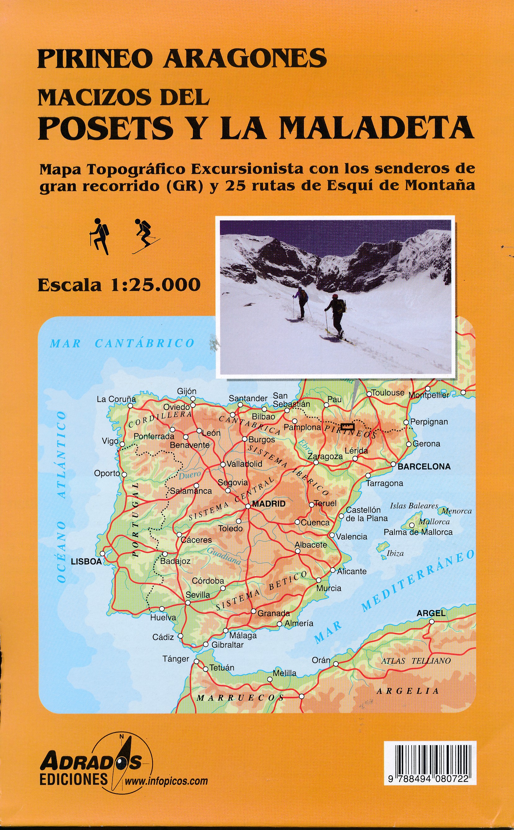
- Posets and la Maladeta Massifs Adrados Map
- Posets and Maladeta Massifs in the central part of the Spanish Pyrenees on a double-sided, contoured and GPS compatible map at 1:25,000 from Adrados Ediciones, with vivid presentation of the topography, hiking or ski trails, campsites and refuges, etc. Coverage extends from Plan and the Zinqueta River west of the Poset massif, across the... Read more
De Zwerver
Netherlands
- Wandelkaart Macizos del Posets Y la Maladeta | Adrados Ediciones
- Posets and Maladeta Massifs in the central part of the Spanish Pyrenees on a double-sided, contoured and GPS compatible map at 1:25,000 from Adrados Ediciones, with vivid presentation of the topography, hiking or ski trails, campsites and refuges, etc. Coverage extends from Plan and the Zinqueta River west of the Poset massif, across the... Read more
Stanfords
United Kingdom
- Pico - S.Roque do Pico - Azores 8
- Topographic survey of Portugal at 1:25,000 from the Instituto Geográfico do Exército, the country’s military survey organisation.Map legend and a glossary of terms used on the maps include English.To see all the titles in this series please click on the series link. Read more
Stanfords
United Kingdom
- S. Jorge - Norte Grande - Azores 16
- Topographic survey of Portugal at 1:25,000 from the Instituto Geográfico do Exército, the country’s military survey organisation.Map legend and a glossary of terms used on the maps include English.To see all the titles in this series please click on the series link. Read more
Stanfords
United Kingdom
- Terceira - Angra do Heroismo - Azores 24
- Topographic survey of Portugal at 1:25,000 from the Instituto Geográfico do Exército, the country’s military survey organisation.Map legend and a glossary of terms used on the maps include English.To see all the titles in this series please click on the series link. Read more
Stanfords
United Kingdom
- S. Miguel - Ponta Delgada - Azores 32
- Topographic survey of Portugal at 1:25,000 from the Instituto Geográfico do Exército, the country’s military survey organisation.Map legend and a glossary of terms used on the maps include English.To see all the titles in this series please click on the series link. Read more