
Stanfords
United Kingdom
- Singapore Periplus Travel Map
- Singapore on a double-sided map by Periplus, providing road mapping of the Singapore Island and Sentosa Island, a street plan of Singapore City with a more detailed enlargement of its Central District, and a diagram of the MRT and LRT transport system.On one side is the whole of the Singapore Island, presented at 1:55,000. Road network... Read more
Stanfords
United Kingdom
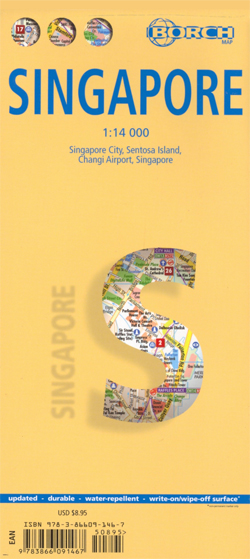
- Singapore Borch
- Laminated and waterproof map for visitors to Singapore from Borch, highlighting top 30 sights and combining a street plan of Singapore city’s central districts with a road map of the Singapore Island, plus maps of Sentosa Island, Changi Airport and public transport network.On one side is a street plan at 1:14,000 of Singapore City’s central... Read more

Stanfords
United Kingdom
- Singapore & Malay Peninsula ITMB
- Singapore City on a clear, indexed street plan at 1:10,000 with from ITMB, highlighting numerous places of interest and tourist facilities, plus the Singapore Island shown at 1:100,000 with its road and rail networks.The street plan covers the city’s central districts as indicated in our area coverage image, including the Financial District,... Read more

Stanfords
United Kingdom
- Singapore SUPERCEDED
- This comprehensive new edition map covers Singapore Island to a scale of 1:55,000 and Sentosa Island to a scale of 1:25,000. City Plans feature Singapore City and Central District. Read more
De Zwerver
Netherlands
De Zwerver
Netherlands