
Burgenland
Description
Eastern Bundesland of Austria, bordering on Hungary.
Trails in this state
Links
Facts
Reports
Guides and maps
Lodging
Organisations
Tour operators
GPS
Other
Books

Stanfords
United Kingdom
United Kingdom
- Styrian Thermal Region - Southern Burgenland - Styrian Vulkanland F&B WK423
- Thermenland Oststeiermark – Südburgenland area of eastern Austria presented at 1:50,000 in a series of contoured and GPS compatible outdoor leisure map from Freytag & Berndt with hiking and cycling routes, mountain huts, campsites and youth hostels, local bus stops, plus other tourist information. To see the list of currently available titles... Read more
- Also available from:
- Bol.com, Belgium

De Zwerver
Netherlands
2022
Netherlands
2022
De Zwerver
Netherlands
2012
Netherlands
2012
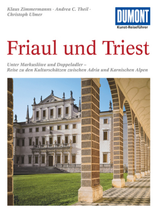
- Reisgids Kunstreiseführer Friaul und Triest | Dumont
- Das Thema dieses Kunst-Reiseführers ist die italienische Region Friaul- Julisch Venetien. Sie besteht aus zwei Provinzen, von denen das Friaul die weitaus größere ist. Julisch Venetien dagegen umfasst seit 1954 nur noch die Stadt Triest und einen kleinen Küstenstreifen bis Muggia. Wie ein Amphitheater liegt das Friaul im äußersten Nordosten... Read more

De Zwerver
Netherlands
2023
Netherlands
2023

Bol.com
Netherlands
Netherlands
- WF5421 Allgäu, Allgäuer Alpen Kompass
- De Kompass wandelgids + kaart geeft een overzicht van alle wandelroutes in het gebied met nauwkeurige routeaanwijzingen en hoogteaanduidingen, De extra grote kaart, schaal 1:35 000, is ideaal om van te voren uw route uit te stippelen en om onderweg te gebruiken • naast de bekende bestemmingen, worden ook de minder bekende vermeld • openbaar... Read more
- Also available from:
- Bol.com, Belgium
Bol.com
Belgium
Belgium
- WF5421 Allgäu, Allgäuer Alpen Kompass
- De Kompass wandelgids + kaart geeft een overzicht van alle wandelroutes in het gebied met nauwkeurige routeaanwijzingen en hoogteaanduidingen, De extra grote kaart, schaal 1:35 000, is ideaal om van te voren uw route uit te stippelen en om onderweg te gebruiken • naast de bekende bestemmingen, worden ook de minder bekende vermeld • openbaar... Read more

Bol.com
Netherlands
2017
Netherlands
2017
- Griechenland: Trans Kreta E4
- Kein Geheimtipp und dennoch etwas in Vergessenheit geraten ist das ber 500 km lange Teilst ck des europ ischen Fernwanderweges E4 auf Kreta. Bereits seit den 1970er-Jahren geh rt dieser Abschnitt zu einem der beliebtesten des l ngsten europ ischen Fernwanderweges und ist somit ein echter Trekkingklassiker.Wer gut markierte Pfade und verl... Read more
- Also available from:
- Bol.com, Belgium
- De Zwerver, Netherlands
Bol.com
Belgium
2017
Belgium
2017
- Griechenland: Trans Kreta E4
- Kein Geheimtipp und dennoch etwas in Vergessenheit geraten ist das ber 500 km lange Teilst ck des europ ischen Fernwanderweges E4 auf Kreta. Bereits seit den 1970er-Jahren geh rt dieser Abschnitt zu einem der beliebtesten des l ngsten europ ischen Fernwanderweges und ist somit ein echter Trekkingklassiker.Wer gut markierte Pfade und verl... Read more

De Zwerver
Netherlands
2017
Netherlands
2017
- Wandelgids E4 Kreta Lefka Ori und Lasithi | Conrad Stein Verlag
- OutdoorHandbuch. 3. Auflage. Read more

De Zwerver
Netherlands
2018
Netherlands
2018
- Wandelgids Tourist route E4 in Bulgaria | Oilaripi
- Verrassend goede wandelgids van een deel van de E4 in Bulgarije. Goede kaarten, hoogteprofielen, prima beschrijvingen en praktische informatie maken het een volwaardige wandelgids die je in eerste instantie van dit gebied niet zou verwachten. Guidebook along the main ridge of the great alpine route E4 in Bulgaria, also known as �the fiv... Read more

Stanfords
United Kingdom
2015
United Kingdom
2015
- Crete High Mountain Walks, the White Mountains, Mt Ida and Lassithi - 3rd ed.
- The High Mountains of Crete is Loraine Wilson’s authoritative Cicerone guide to the best walking routes in Crete’s mountainous regions. The guide covers walks in the well-known Samaria Gorge and the other dramatic gorges and numerous peaks rising to over 2100m, alongside high mountain plains, forested crags, massive cliffs and remote beaches.... Read more
- Also available from:
- The Book Depository, United Kingdom
- Bol.com, Netherlands
- Bol.com, Belgium
- De Zwerver, Netherlands

The Book Depository
United Kingdom
2015
United Kingdom
2015
- The High Mountains of Crete
- The White Mountains, Psiloritis and Lassithi Mountains Read more

Bol.com
Netherlands
2015
Netherlands
2015
- The high mountains of Crete
- Guidebook to walking and trekking the high mountains of Crete. The largest of the Greek Islands, Crete's mountains provide breathtaking walking and wilderness on this popular island. The routes in this guidebook are graded for difficulty and range from short, easy strolls to challenging, multi-day treks, providing options for all walkers. In... Read more
Bol.com
Belgium
2015
Belgium
2015
- The high mountains of Crete
- Guidebook to walking and trekking the high mountains of Crete. The largest of the Greek Islands, Crete's mountains provide breathtaking walking and wilderness on this popular island. The routes in this guidebook are graded for difficulty and range from short, easy strolls to challenging, multi-day treks, providing options for all walkers. In... Read more

De Zwerver
Netherlands
2015
Netherlands
2015
- Wandelgids The high mountains of Crete - Kreta | Cicerone
- Guidebook of walking routes in Crete's mountains, covering the Lefka Ori (White Mountains), Mount Ida (the Psiloritis range), the Lassithi mountains and E4 trail. Each of the 87 walks is graded, in a range between 2 and 28km with various longer options, covering a multitude of terrains from rugged mountain ridges to forested crags and beaches. Read more
Bol.com
Netherlands
Netherlands
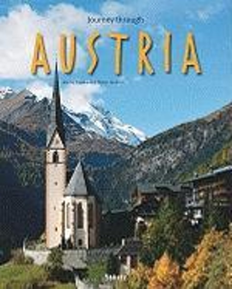
- Journey Through Austria
- Exploring one of the most popular destinations in Europe, this photographic guide illustrates Austria s diverse scenery from Bregenz to the Viennese Forest and from the Salzkammergut to Styria. Snowcapped mountains interspersed with wooden hillsides and serene lakes are depicted, stretching as far as the plateau of the Burgenland. The country s... Read more
- Also available from:
- Bol.com, Belgium
Bol.com
Belgium
Belgium
- Journey Through Austria
- Exploring one of the most popular destinations in Europe, this photographic guide illustrates Austria s diverse scenery from Bregenz to the Viennese Forest and from the Salzkammergut to Styria. Snowcapped mountains interspersed with wooden hillsides and serene lakes are depicted, stretching as far as the plateau of the Burgenland. The country s... Read more
Maps

Stanfords
United Kingdom
United Kingdom
- South-East Styrian Hills - Vulkanland - Bad Gleichenberg - Bad Radkersburg F&B WK412
- Southern Styrian Hills - Vulkanland - Bad Gleichenberg - Bad Radkersburg area of south-eastern Austria presented at 1:50,000 in a series of contoured and GPS compatible outdoor leisure map from Freytag & Berndt with hiking and cycling routes, mountain huts, campsites and youth hostels, local bus stops, plus other tourist information. To see the... Read more

Stanfords
United Kingdom
United Kingdom
- Stara Planina Central: Uzana to Vratnik Domino Map
- Stara Planina Central: Uzana to Vratnik map at 1:50,000 from Bulgarian publishers Domino, contoured and GPS compatible, with hiking trails, accommodation options including a list of local mountain refuges, etc. The map is double-sided and covers the mountains from just west of the Uzana massif, the geographical centre of Bulgaria, eastwards to... Read more
- Also available from:
- De Zwerver, Netherlands

De Zwerver
Netherlands
Netherlands
- Wandelkaart 2 Stara Planina gebergte | Domino
- Stara Planina Central: Uzana to Vratnik map at 1:50,000 from Bulgarian publishers Domino, contoured and GPS compatible, with hiking trails, accommodation options including a list of local mountain refuges, etc. The map is double-sided and covers the mountains from just west of the Uzana massif, the geographical centre of Bulgaria, eastwards to... Read more

Stanfords
United Kingdom
United Kingdom
- Western Crete Terrain Editions 448
- Western Crete at 1:100,000 on an indexed, GPS compatible road map from Terrain Editions, printed on light, waterproof and tear-resistant plastic paper, with a street plan of central Chania.This title is part of a series which covers Crete in three sheets. The maps have contours at 100m intervals, enhanced by relief shading with spot heights and... Read more
- Also available from:
- De Zwerver, Netherlands

De Zwerver
Netherlands
Netherlands
- Wandelkaart - Fietskaart - Wegenkaart - landkaart 448 Western Crete - Kreta West | Terrain maps
- Western Crete at 1:100,000 on an indexed, GPS compatible road map from Terrain Editions, printed on light, waterproof and tear-resistant plastic paper, with a street plan of central Chania.This title is part of a series which covers Crete in three sheets. The maps have contours at 100m intervals, enhanced by relief shading with spot heights and... Read more

Stanfords
United Kingdom
United Kingdom
- Olympus Geopsis 139
- Mt Olympus in a series of waterproof and tear-resistant hiking maps at scales varying from 1:50,000 to 1:10,000, with a UTM grid for GPS users. Contour interval varies depending on the scale, on most maps it is 20m. Relief shading, spot heights, springs, seasonal streams and, in most titles, landscape/land-use variations, e.g. forests,... Read more

Stanfords
United Kingdom
United Kingdom
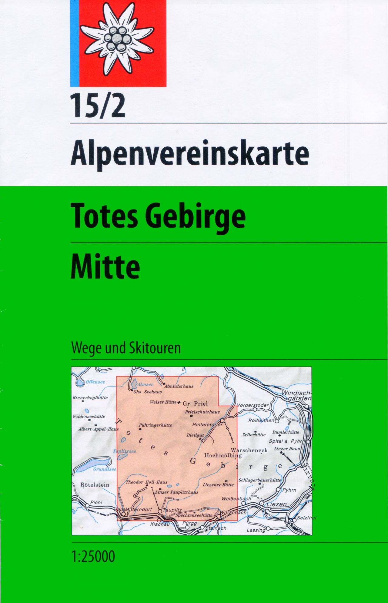
- Totes Gebirge Central Alpenverein KOMBI Map 15/2
- Totes Gebirge Central area of the Alps in a hiking edition at 1:25,000 from a series of detailed, GPS compatible maps published by the DAV - Deutscher Alpenverein and produced by the German and Austrian Alpine Clubs using cartography from their respective survey organizations. Maps in this series have topography vividly presented by contours at... Read more
- Also available from:
- De Zwerver, Netherlands
De Zwerver
Netherlands
Netherlands
- Wandelkaart 15/2 Alpenvereinskarte Totes Gebirge - Mitte | Alpenverein
- Totes Gebirge Central area of the Alps in a hiking edition at 1:25,000 from a series of detailed, GPS compatible maps published by the DAV - Deutscher Alpenverein and produced by the German and Austrian Alpine Clubs using cartography from their respective survey organizations. Maps in this series have topography vividly presented by contours at... Read more

Stanfords
United Kingdom
United Kingdom
- Hungarian National Long-distance Blue Trail (E4): Visegrad to Irott-ko
- Hiking guide to the north-western section of Hungary’s National Blue Trail which forms part of the E4 European long-distance footpath. The guide covers the route from the historic town of Visegrád on the Danube, across the Buda Hills on the outskirts of Budapest and the Bakony Hills along the north-eastern shore of Lake Balaton, to Írott-ko in... Read more

Stanfords
United Kingdom
United Kingdom
- Stara Planina Western: Belogradchik to Berkovita Domino Map
- Stara Planina Western: Belogradchik to Berkovita map at 1:50,000 from Bulgarian publishers Domino, contoured and GPS compatible, with hiking trails, accommodation options including a list of local mountain refuges, etc. The map is double-sided and covers the mountains from the peak of Byala Voda near Belogradchik eastwards to just beyond... Read more
- Also available from:
- De Zwerver, Netherlands

De Zwerver
Netherlands
Netherlands
- Wandelkaart 3 Stara Planina gebergte | Domino
- Stara Planina Western: Belogradchik to Berkovita map at 1:50,000 from Bulgarian publishers Domino, contoured and GPS compatible, with hiking trails, accommodation options including a list of local mountain refuges, etc. The map is double-sided and covers the mountains from the peak of Byala Voda near Belogradchik eastwards to just beyond... Read more

Stanfords
United Kingdom
United Kingdom
- Eastern Crete Terrain Editions 450
- Eastern Crete at 1:100,000 on an indexed, GPS compatible road map from Terrain Editions, printed on light, waterproof and tear-resistant plastic paper, with a street plan of central Aghios Nikolaos.This title is part of a series which covers Crete in three sheets. The maps have contours at 100m intervals, enhanced by relief shading with spot... Read more
- Also available from:
- De Zwerver, Netherlands

De Zwerver
Netherlands
Netherlands
- Wandelkaart - Fietskaart - Wegenkaart - landkaart 450 Eastern Crete - Kreta Oost | Terrain maps
- Eastern Crete at 1:100,000 on an indexed, GPS compatible road map from Terrain Editions, printed on light, waterproof and tear-resistant plastic paper, with a street plan of central Aghios Nikolaos.This title is part of a series which covers Crete in three sheets. The maps have contours at 100m intervals, enhanced by relief shading with spot... Read more

Stanfords
United Kingdom
United Kingdom
- E4 Arquipelago de Cabo Verde
- Plans included:Porto Novo (Ilha de Santo Antão) (1:10 000)Mindelo (Porto Grande) (Ilha de São Vicente) (1:20 000)Ilha de Santa Luzia (1:not known)Porto de Tarrafal (Ilha de São Nicolau) (1:8500)Porto da Preguiça (Ilha de São Nicolau) (1:8500)Baía da Palmeira (Ilha do Sal) (1:15 000)Porto de Sal-Rei (Ilha da Boavista) (1:30 000)Porto da Praia... Read more

Stanfords
United Kingdom
United Kingdom
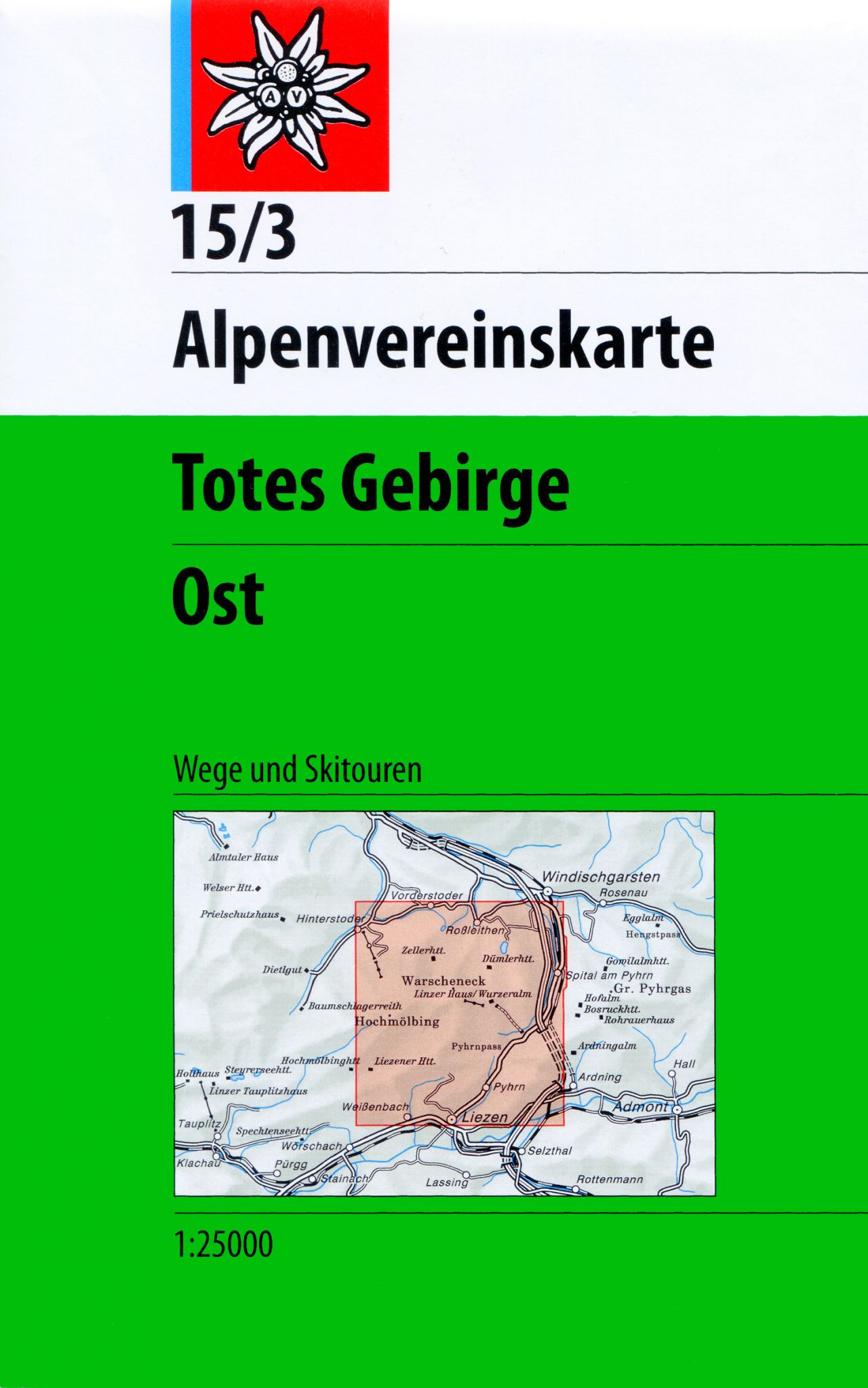
- Totes Gebirge East Alpenverein KOMBI Map 15/3
- Totes Gebirge East area of the Alps in a combined hiking and ski edition at 1:25,000 from a series of detailed, GPS compatible maps published by the DAV - Deutscher Alpenverein and produced by the German and Austrian Alpine Clubs using cartography from their respective survey organizations. Maps in this series have topography vividly presented... Read more
- Also available from:
- De Zwerver, Netherlands
De Zwerver
Netherlands
Netherlands
- Wandelkaart 15/3 Alpenvereinskarte Totes Gebirge - Ost | Alpenverein
- Totes Gebirge East area of the Alps in a combined hiking and ski edition at 1:25,000 from a series of detailed, GPS compatible maps published by the DAV - Deutscher Alpenverein and produced by the German and Austrian Alpine Clubs using cartography from their respective survey organizations. Maps in this series have topography vividly presented... Read more

Stanfords
United Kingdom
United Kingdom
- Burgenland
- One of the titles in a series of provincial topographic maps derived from generalising the cartography of the 1:50,000 survey. Topography is shown by contours at 100m intervals, spot heights, hill-shading and graphic relief. Colours and graphics distinguish landscape types e.g. forests, vineyards, swamps. The attractive, finely-drawn detail... Read more

Stanfords
United Kingdom
United Kingdom
- Stara Planina Western: Berkovita to Zlatitsa Domino Map
- Stara Planina Western: Berkovita to Zlatitsa map at 1:50,000 from Bulgarian publishers Domino, contoured and GPS compatible, with hiking trails, accommodation options including a list of local mountain refuges, etc. The map is double-sided and covers the mountains from Varshets (directly north of Sofia) to just beyond Etrepole.Maps in the... Read more
- Also available from:
- De Zwerver, Netherlands

De Zwerver
Netherlands
Netherlands
- Wandelkaart 4 Stara Planina gebergte | Domino
- Stara Planina Western: Berkovita to Zlatitsa map at 1:50,000 from Bulgarian publishers Domino, contoured and GPS compatible, with hiking trails, accommodation options including a list of local mountain refuges, etc. The map is double-sided and covers the mountains from Varshets (directly north of Sofia) to just beyond Etrepole.Maps in the... Read more

Stanfords
United Kingdom
United Kingdom
- Central Crete Terrain Editions 449
- Central Crete at 1:100,000 on an indexed, GPS compatible road map from Terrain Editions, printed on light, waterproof and tear-resistant plastic paper, with street plans of central Heraklion and Rethymno.This title is part of a series which covers Crete in three sheets. The maps have contours at 100m intervals, enhanced by relief shading with... Read more
- Also available from:
- De Zwerver, Netherlands

De Zwerver
Netherlands
Netherlands
- Wandelkaart - Fietskaart - Wegenkaart - landkaart 449 Central Crete - Kreta centraal | Terrain maps
- Central Crete at 1:100,000 on an indexed, GPS compatible road map from Terrain Editions, printed on light, waterproof and tear-resistant plastic paper, with street plans of central Heraklion and Rethymno.This title is part of a series which covers Crete in three sheets. The maps have contours at 100m intervals, enhanced by relief shading with... Read more

Stanfords
United Kingdom
United Kingdom
- Bregenz F&B
- Indexed street plan of Bregenz extending north along the Bodensee coast to Lochau and Unter Hochsteg. Detail includes pedestrianised areas, railways, bus routes and cycle paths. Notable buildings are highlighted in red, and symbols indicate post offices, hostels, campsites and car parks.On the reverse is a 1:50,000 contoured map of the... Read more

Stanfords
United Kingdom
United Kingdom
- Burgenland Bikeline Cycling Atlas
- Cycling atlas of the Burgenland province of Austria at 1:75,000 from Verlag Esterbauer with essential information on accommodation, repair facilities, etc. All the text is in GERMAN only but extensive map legend includes English, as shown on our sample image.Esterbauer’s Bikeline guides in this series can be used without any knowledge of... Read more