
Rheinland-Pfalz
Description
Trails in this state
- Ahr-Venn-WegGPX
- AhrtalwegGPX
- Alsenztal Wanderweg
- AusoniuswegGPX
- BonifatiuswegGPX
- Deutsche WeinstrasseGPX
- E1GPX
- E8GPX
- EifelsteigGPX
- Erft-Lieser-Mosel-Weg GPX
- GR15 - AE - Ardennes-EifelGPX
- GR5GPX
- Hessenweg 7GPX
- Hunsrück Höhenweg
- Jakobsweg im Elsass
- Josef-Schramm-Weg GPX
- Karl-Kaufmann-WegGPX
- KarolingerwegGPX
- KrönungswegGPX
- Lahn WanderwegGPX
- LahnhöhenwegGPX
- LieserpfadGPX
- MatthiaswegGPX
- Mosel-OurwegGPX
- MoselhöhenwegGPX
- MoselsteigGPX
- Nahe HöhenwegGPX
- NibelungenwegGPX
- Pfälzer WeinsteigGPX
- Rhein-Kyll-WegGPX
- Rhein-Rureifel-Weg GPX
- RheinburgenwegGPX
- Rheingauer Riesling Routen
- RheinhöhenwegGPX
- RheinsteigGPX
- Rotwein WanderwegGPX
- Saar-HunsrücksteigGPX
- SchinderhannespfadGPX
- Siegerland HöhenringGPX
- SironawegGPX
- SoonwaldsteigGPX
- SponheimerwegGPX
- Taunus HöhenwegGPX
- VulkanwegGPX
- Weinwanderweg Rhein-NaheGPX
- WesterwaldsteigGPX
- Westpfalz WanderwegGPX
- WillibrorduswegGPX
Links
Facts
Reports
Guides and maps
Lodging
Organisations
Tour operators
GPS
Other
Books
Stanfords
United Kingdom
2020
United Kingdom
2020
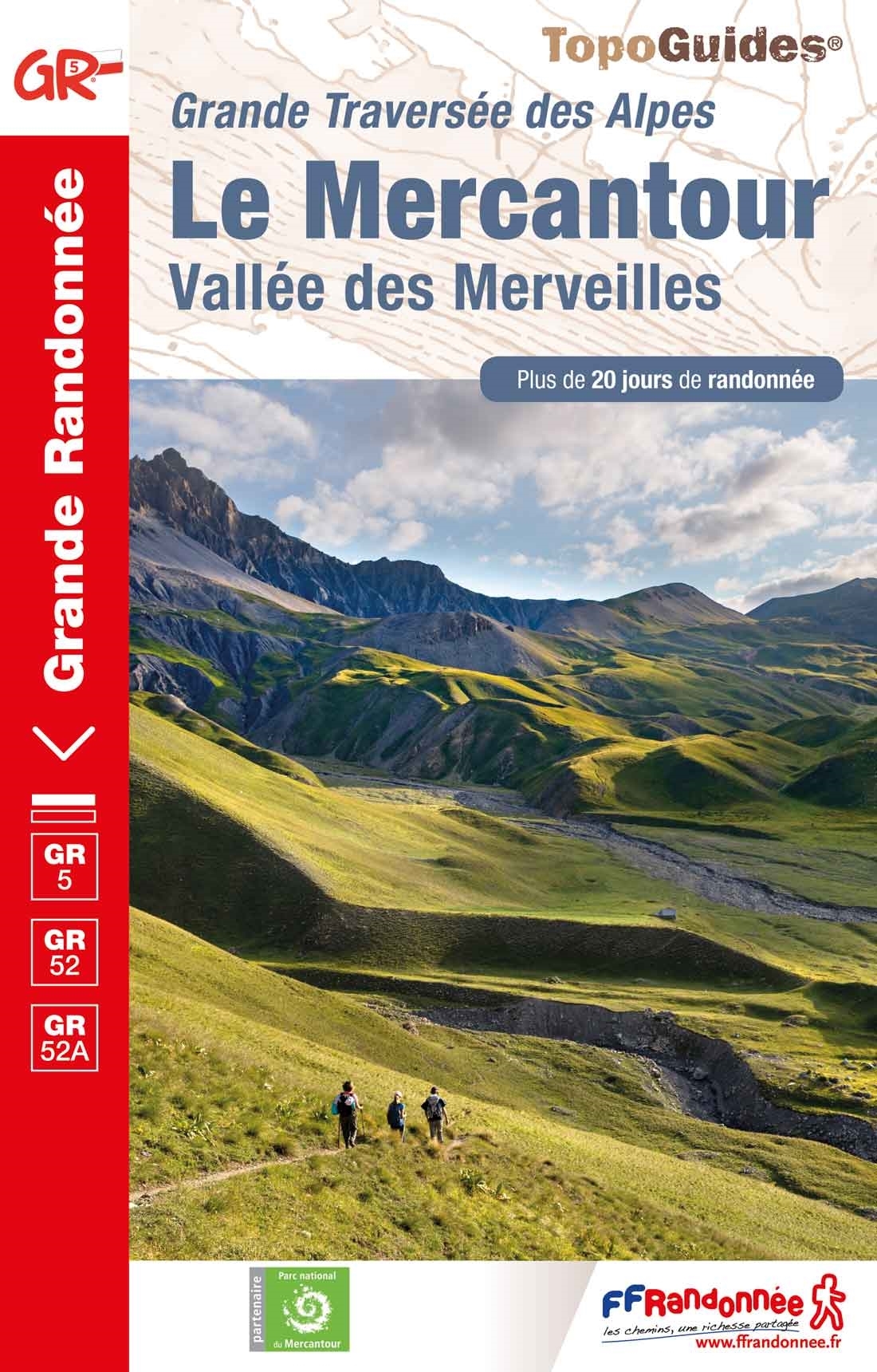
- Le Mercantour - Vallee des Merveilles GR5/GR52/52A
- Le Mercantour: Larche – Nice/Menton, Vallée des Merveilles, FFRP topoguide Ref. No. 507, covering 450km of long-distance routes: the last section of the GR5 in the French Alps from Larche to Nice, an alternative variant off GR5 along the GR52 leading via the Vallée des Merveilles to Menton, plus GR52A – Panoramique du Mecantour from Col du... Read more

Stanfords
United Kingdom
2020
United Kingdom
2020
- La Traversee der Alpes La Vanoise - PN de la Vanoise GR5/GR55
- 15 days in altitude from the Tarentaise to Modane, heart of the Maurienne. Description also of Via Alpina.La Vanoise (including Parc National de la Vanoise), FFRP topoguide Ref. no. 530, covering the second section of the GR5 in the French Alps between Landry and Modane, its lower variant on the GR5E along the river Arc, plus the traverse of... Read more
Stanfords
United Kingdom
2021
United Kingdom
2021
- Tour de l`Oisans et des Ecrins - Parc National des Ecrins GR54/GR541
- Tour de l`Oisans et des Ecrins, FFRP topoguide, Ref. No. 508, covering the 11 to 13 days long tour of the Ecrins massif along the GR54, including the local section of the GR5. Variants along GRs 54A, 54B, 54C, and 541 offer less demanding circuits of two to three days. Current edition of this title was published in April 2014.To see other... Read more

Stanfords
United Kingdom
2019
United Kingdom
2019
- Du Léman à la Vanoise - par le Mont Blanc et le Beaufortain GR5
- The first, 206-km long Alpine section of the GR5 from Lake Geneva, past Mont Blanc and across the Col de la Croix-du-Bonhomme, to Landry north of the Vanoise Massif, FFRP topo-guide ref. no. 504, with colour maps from the IGN TOP25 series at 1:25,000. Also included is a tour of the Dents du Midi. Current edition of this title was published in... Read more

Stanfords
United Kingdom
2019
United Kingdom
2019
- La Traversée des Alpes de la Maurienne a l`Ubaye GR5/GR56
- 9 days from Modane to Larche by the GR5, as much for the tour of Ubaye.Grande Traversée des Alpes: de la Maurienne a l`Ubaye, FFRP topoguide Ref. No. 531, covering the third stage of the GR5 in the French Alps from Modane to Larche, plus the Tour de l`Ubaye at its southern end, in all 272km for hiking routes. Current edition of this title was... Read more
Stanfords
United Kingdom
2019
United Kingdom
2019
- La Grande Traversee du Jura GR5/GR9/GTJ
- La Grande Travesée du Jura, FFRP topoguide Ref. no. 512, covering the GTJ along the Jura Mountains in France from Nommay to Culoz, plus several variants off the main route including parts of the GR5 and GR9 – in all 509kms of hiking trails. Current edition of this title was published in March 2017.The GR509 offers hikers a path punctuated by... Read more

- Also available from:
- De Zwerver, Netherlands

De Zwerver
Netherlands
2021
Netherlands
2021

The Book Depository
United Kingdom
2022
United Kingdom
2022
- Also available from:
- De Zwerver, Netherlands


The Book Depository
United Kingdom
2018
United Kingdom
2018
- The GR5 Trail - Benelux and Lorraine
- The North Sea to Schirmeck in the Vosges mountains Read more
- Also available from:
- De Zwerver, Netherlands

De Zwerver
Netherlands
2018
Netherlands
2018
- Wandelgids The GR5 Trail Benelux and Lorraine | Cicerone
- Guidebook to walking the northern section of the GR5 - 1000km starting in Hoek van Holland and passing through the Netherlands, Belgium, Luxembourg and Lorraine to Schirmeck in France. A long-distance route covering a variety of cultures and landscapes. The full GR5 from the North Sea to the Mediterranean is one of the world's greatest trails. Read more


The Book Depository
United Kingdom
2016
United Kingdom
2016
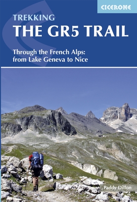
- The GR5 Trail
- Through the French Alps from Lake Geneva to Nice Read more
- Also available from:
- Bol.com, Netherlands
- Bol.com, Belgium
- De Zwerver, Netherlands
Bol.com
Netherlands
2016
Netherlands
2016
- The GR5 trail
- The GR5 is one of the world's most spectacular long-distance trails. This guide describes the route from the shores of Lac L man (lake Geneva) over the Alps and down to the trail's finish at Nice. Interesting variant routes include the stunning GR55 through the Vanoise National Park and the GR52, which crosses the Mercantour National Park to... Read more
Bol.com
Belgium
2016
Belgium
2016
- The GR5 trail
- The GR5 is one of the world's most spectacular long-distance trails. This guide describes the route from the shores of Lac L man (lake Geneva) over the Alps and down to the trail's finish at Nice. Interesting variant routes include the stunning GR55 through the Vanoise National Park and the GR52, which crosses the Mercantour National Park to... Read more
De Zwerver
Netherlands
2016
Netherlands
2016
- Wandelgids The GR5 Trail - The Alps | Cicerone
- An essential guidebook for walking the GR5 trail, 660km from Lac Leman (Lake Geneva) to Nice or Menton, through the French Alps. Includes all the main variant routes as it passes Mont Blanc, then through the Vanoise, the Queyras and the Mercantour National Parks. Includes accommodation, profiles and maps. Suitable for fairly experienced hikers. Read more
De Zwerver
Netherlands
2022
Netherlands
2022
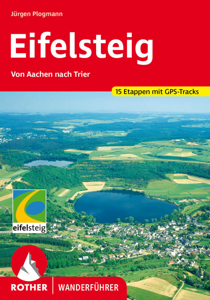
- Wandelgids Eifelsteig | Rother Bergverlag
- Goede gids met duidelijke kaarten en mooie foto's beschrijft de prachtige wandeltocht van Aachen, vlakbij het drielandenpunt, naar Trier in 15 etappes. De route voert langs prachtige rotsgebieden zoals de Gerolsteiner Dolomieten met watervallen. De Rother wandelgidsen beschrijven zeer goed de wandelingen in specifieke gebieden. In de gids... Read more

Bol.com
Netherlands
Netherlands
- EifelSteig Schöneres Wandern Pocket
- Auf den Spuren der Römer durch die nördliche Eifel, zu malerischen Burgen des Mittelalters und durch romantische Fachwerkstädte: Der Eifelsteig verbindet die Kaiserstadt Aachen mit der Römerstadt Trier. Dazwischen liegen mehr als 330 abwechslungsreiche Kilometer mit herrlichen Ausblicken auf eine durch Wasser-, Wiesen und Wälder geprägte... Read more
- Also available from:
- Bol.com, Belgium
Bol.com
Belgium
Belgium
- EifelSteig Schöneres Wandern Pocket
- Auf den Spuren der Römer durch die nördliche Eifel, zu malerischen Burgen des Mittelalters und durch romantische Fachwerkstädte: Der Eifelsteig verbindet die Kaiserstadt Aachen mit der Römerstadt Trier. Dazwischen liegen mehr als 330 abwechslungsreiche Kilometer mit herrlichen Ausblicken auf eine durch Wasser-, Wiesen und Wälder geprägte... Read more
Bol.com
Netherlands
Netherlands
- Spessart mit Frankfurt am Main
- Die KOMPASS Wanderführer bieten neben spannenden Destinationen und tollen Wandertourenauch viele praktische Tipps und Zusatzinformationen wie z. Bsp. Sehenswürdigkeiten oder Einkehrmöglichkeiten.Alle Touren sind von den jeweiligen Autoren selbst erwandert und enthalten detaillierte Angaben zu Schwierigkeitsgrad, Höhenmetern und Gehzeit.De... Read more
- Also available from:
- Bol.com, Belgium
Bol.com
Belgium
Belgium
- Spessart mit Frankfurt am Main
- Die KOMPASS Wanderführer bieten neben spannenden Destinationen und tollen Wandertourenauch viele praktische Tipps und Zusatzinformationen wie z. Bsp. Sehenswürdigkeiten oder Einkehrmöglichkeiten.Alle Touren sind von den jeweiligen Autoren selbst erwandert und enthalten detaillierte Angaben zu Schwierigkeitsgrad, Höhenmetern und Gehzeit.De... Read more
Maps

Stanfords
United Kingdom
2012
United Kingdom
2012
- Eifelsteig Long-distance Trail: Aachen to Trier
- Eifelsteig, a long-distance hiking route from Trier to Aachen across some of the Eifel’s most picturesque towns: Wittlich, Daun, Gerolstein, and Monschau, on a GPS compatible, topographic recreational map at 1:50,000 from the survey organization of Rhineland-Palatinate. The course of the route is presented on three overlapping panels and is... Read more

Stanfords
United Kingdom
United Kingdom
- Colline di Forlí
- Map No. 127, Colline di Forlí, in a series of GPS compatible hiking maps at 1:50,000 from the Istituto Geografico Adriatico, covering parts of central Italy: eastern Tuscany, with northern Umbria and the Marches, plus the south-eastern of part of Emilia-Romagna.The maps have contours at 50m intervals with additional shading and numerous spot... Read more

Stanfords
United Kingdom
United Kingdom
- Alsace - Mulhouse - Basel - Altkirch K+F Outdoor Map 2
- The southern part of Alsace around Mulhouse and Guebwiller on a GPS compatible, double-sided map at 1:50,000 from Kümmerly+Frey printed on sturdy, waterproof and tear-resistant synthetic paper; contoured, with hiking and cycling routes, sites for other recreational activities, various accommodation options, restaurants and ferme-auberge... Read more

Stanfords
United Kingdom
United Kingdom
- Alta Valle del Lamone 22
- Map No. 22, Alta Valle del Lamone: Alto Appennino Faentino – Anello di Marradi, in series of contoured, GPS compatible hiking maps at 1:25,000 from the Istituto Geografico Adriatico, covering mainly the spine of the Apennines along the borders of Tuscany, Emilia-Romagna, Umbria and the Marches.Map in this series have contours at 25m intervals... Read more
Stanfords
United Kingdom
United Kingdom
- Appennino Tosco-Romagnolo East
- Map No. 135, Appennino Tosco-Romagnolo East, in a series of GPS compatible hiking maps at 1:50,000 from the Istituto Geografico Adriatico, covering parts of central Italy: eastern Tuscany, with northern Umbria and the Marches, plus the south-eastern of part of Emilia-Romagna.The maps have contours at 50m intervals with additional shading and... Read more

Stanfords
United Kingdom
United Kingdom
- Monte Fumaiolo - Monte Comero 18
- Map No. 18, Monte Fumaiolo - Alto Tevere, in series of contoured, GPS compatible hiking maps at 1:25,000 from the Istituto Geografico Adriatico, covering mainly the spine of the Apennines along the borders of Tuscany, Emilia-Romagna, Umbria and the Marches.Map in this series have contours at 25m intervals with additional shading and numerous... Read more
Stanfords
United Kingdom
United Kingdom
- Alta Val Tiberina
- Map No. 125, Alta Val Tiberina, in a series of GPS compatible hiking maps at 1:50,000 from the Istituto Geografico Adriatico, covering parts of central Italy: eastern Tuscany, with northern Umbria and the Marches, plus the south-eastern of part of Emilia-Romagna.The maps have contours at 50m intervals with additional shading and numerous spot... Read more

Stanfords
United Kingdom
United Kingdom
- Rhineland-Palatinate - Saarland Marco Polo Regional Map 10
- German states of Rhineland-Palatinate (Rheinland-Pfalz) and Saarland on an indexed road map at 1:200,000 in the MairDumont’s Marco Polo series, prominently highlighting interesting locations and protected areas. A 95-page index booklet includes city centre street plans plus enlargements at 1:100,000 showing in greater detail the environs and... Read more
Stanfords
United Kingdom
United Kingdom
- Bagno di Romagna Monti Editore 19
- Map No. 19, Bagno di Romagna, in series of contoured, GPS compatible hiking maps at 1:25,000 from the Istituto Geografico Adriatico, covering mainly the spine of the Apennines along the borders of Tuscany, Emilia-Romagna, Umbria and the Marches.The maps have contours at 25m intervals with additional shading and numerous Map in this series have... Read more
Stanfords
United Kingdom
United Kingdom
- Riviera Cesenate - San Marino
- Map No. 128, Riviera Cesenate - San Marino, in a series of GPS compatible hiking maps at 1:50,000 from the Istituto Geografico Adriatico, covering parts of central Italy: eastern Tuscany, with northern Umbria and the Marches, plus the south-eastern of part of Emilia-Romagna.The maps have contours at 50m intervals with additional shading and... Read more

Stanfords
United Kingdom
United Kingdom
- Nassau Nature Park
- Nassau Nature Park, on the eastern bank of the Rhine between Koblenz and Limburg an der Lahn, on a GPS compatible, topographic recreational map at 1:50,000 from the survey organization of Rhineland-Palatinate with cartography identical to the standard topographic survey of Germany but with additional extensive overprint highlighting local and... Read more

Stanfords
United Kingdom
United Kingdom
- Roman Border (Limes) in Rhineland-Palatinate: Rheinbrohl to Saalburg (Hessen)
- Hiking and cycling route along the ancient limes, the Upper Germanic-Rhaetian boundary of the Roman Empire, on a detailed, GPS compatible topographic map at 1:50,000 from the state survey of Rhineland-Palatinate. The route along the limes, one of the outstanding archaeological monuments in Central Europe and a UNESCO World Heritage site, is... Read more

Stanfords
United Kingdom
United Kingdom
- Luxembourg North
- One of two topographic survey maps of Luxembourg at 1:50,000, with contours at 10-metres intervals and additional relief shading. An overprint highlights long-distance footpaths, including the GR5 (E-2), cycle routes, and various places of interest, including campsites. The map covers an area of approximately 53 x 43 km / 33 x 27 miles. Map... Read more
Stanfords
United Kingdom
United Kingdom
- Monte Carpegna - Sasso di Simone
- Map No. 16, Monte Carpegna - Sasso di Simone, in series of contoured, GPS compatible hiking maps at 1:25,000 from the Istituto Geografico Adriatico, covering mainly the spine of the Apennines along the borders of Tuscany, Emilia-Romagna, Umbria and the Marches.Map in this series have contours at 25m intervals with additional shading and... Read more

Stanfords
United Kingdom
United Kingdom
- Rheinsteig long-distance Trail Kompass 2503
- The Rheinsteig, a 306km long-distance hiking trail from Bonn to Wiesbaden along the right bank of the Rhine, including a 65km stretch of the Middle Rhine Valley, a UNESCO World Heritage area and home to many castles, historic towns and vineyards which have inspiration for many writers, artists and composers. The route is presented on 16 panels,... Read more