E2
Description
- Name E2 (E2)
- Length of trail 4,850 km, 3,014 miles
- Length in days 250 days
- Start of trail Galway (Irl)
- End of trail Nice (F)
- Traildino grading EW, Easy walk, nature trail

North Sea – Lake Geneva – Mediterranean Sea
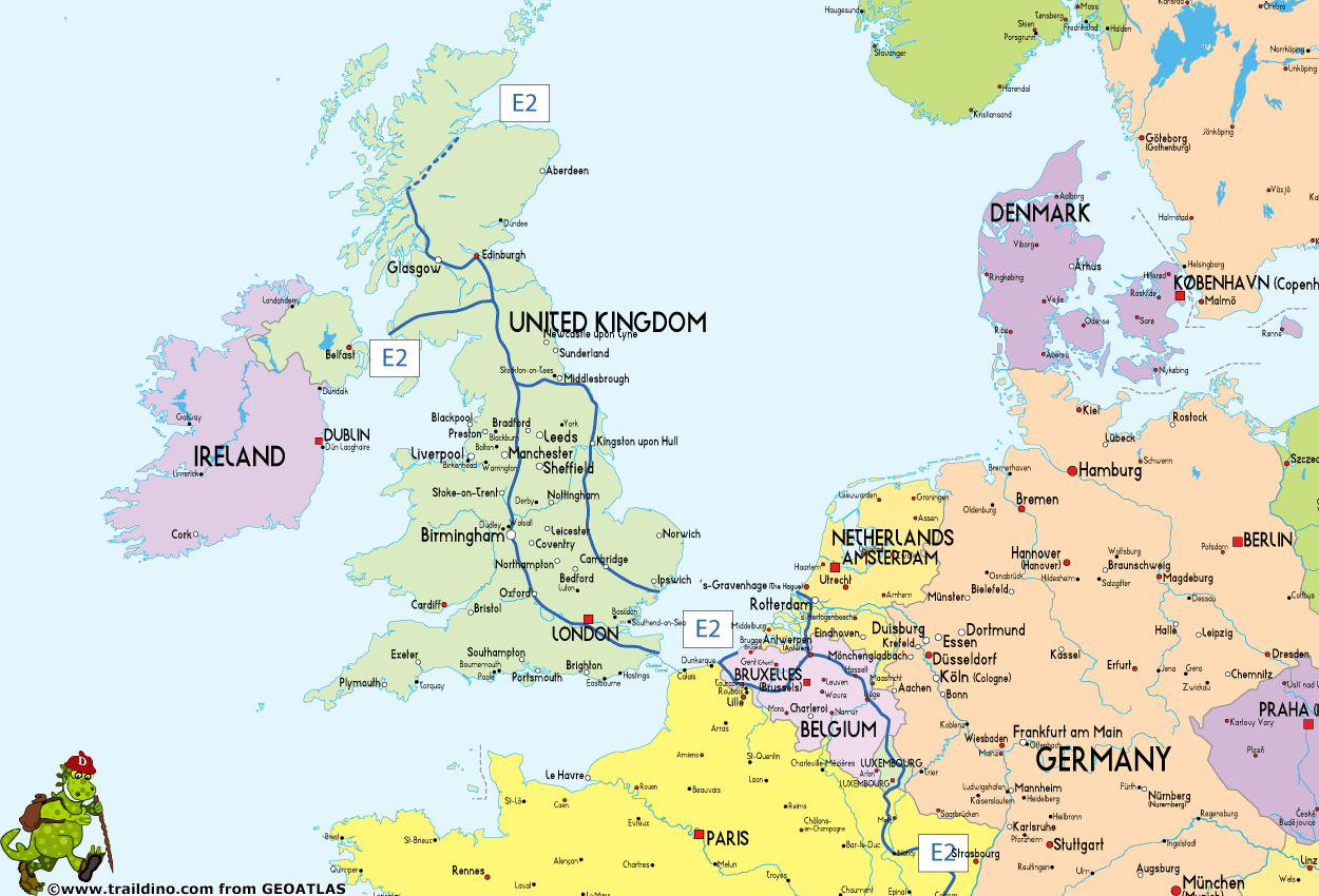
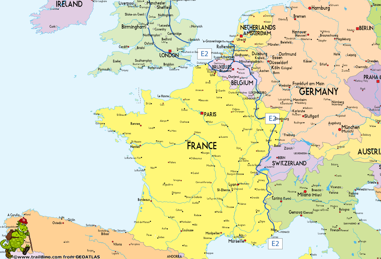
Trail planned to measure 4850 km, from Galway in Ireland to Nice in southern France. However the Irish portion is as yet non-existent. The trail now starts from Stranrear in Scotland, Great Britain and runs (and is waymarked) through the Netherlands/Belgium, Luxembourg and Switzerland, meandering in and out of France along the way. It ends on the French Mediterranean coast in Nice.
In Britain, after leaving the Pennine range, the trail splits into 2 alternative routes: the eastern route via Harwich, and the western route via Dover. After crossing to the continent the eastern route continues in the Netherlands, the western route in Belgium. The alternatives rejoin near the Belgian town of Zoersel.
The continental part of the E2 is almost identical to the popular GR5, the trail that connects Hoek van Holland in The Netherlands to Nice in France.
The E2 is made-up of many national trails:
Ireland
- Non-existent
- Galway will be future start
United Kingdom
Northern Route (unofficial)
- Inverness, start
- Great Glenn Way
- West Highland Way
Central Route
- Stranraer, current start
- Southern Upland Way
- St. Cuthbert's Way
- Pennine Way
Eastern branch
- Teesdale Way
- Cleveland way
- Yorkshire Wolds Way
- Viking Way
- Hereward Way
- Fen Rivers Way
- Icknield Way Path
- Stour Valley Path
- Essex Way
- Ferry Harwich – Hoek van Holland (Netherlands, connects to northern branch)
Western branch
- Pennine Way
- Staffordshire Way
- Heart of England Way
- Oxfordshire Way
- Oxford Canal Walk
- Thames Path
- North Downs Way
- Ferry Dover – Calais (France, connects to southern branch). (As some of you pointed out: The ferry Dover - Oostende is not operated anymore. Alternative: Channel Tunnel between Folkestone and Coquelles near Calais, France).
Netherlands (Northern branch)
- First village is Hoek van Holland
- Deltapad (LAW 5-1), Hoek van Holland - Bergen op Zoom
- GR5, Bergen op Zoom - Essen
Belgium
Southern branch, coming from United Kingdom
- First village is Oostende
- GR5a south, Oostende - Antwerpen
- Antwerpen - Deurne, Connecting trail
- GR565, Renier Sniederspad, Deurne - Zoersel,
- GR5 coming from the Netherlands, Zoersel - Diest - Luik - Luxembourg
Northern branch, coming from The Netherlands
- First village is Essen
- GR5, Essen - Ouren
- Last village is Ouren
Luxembourg (212 km)
- GR5 (red paint stops)
This could be broken down to the following paths:
- Our Path, Ouren – Diekirch. Near Hosingen, the E3 coming from the west joins the E2 / GR5
- Maurice Cosyn Path, Diekirch – Echternach
- Lower-Sûre Path, Echternach - Wasserbillig
- Moselle Path, Wasserbillig – Remerschen. Here, the E3 and E2 / GR5 are separated again
- South Path, Remerschen – Tétange / Rumelange
- Last village is Tétange / Rumelange
France
Switzerland
- Jura Höhenweg (southern tip, across Lake Geneva)
France again
- GR5
- Nice, finish
Map
Links
Facts
Reports
Guides and maps
Lodging
Organisations
Tour operators
GPS
Other
Books

United Kingdom
- Maidstone, Royal Tunbridge Wells, Sevenoaks & Tonbridge OS Landranger Active Map 188 (waterproof)
- Maidstone, Tunbridge Wells and the High Weald area, including a section of the North Downs Way / E2 European Long-distance Path, on a waterproof and tear-resistant OS Active version of map No. 188 from the Ordnance Survey’s Landranger series at 1:50,000, with contoured and GPS compatible topographic mapping plus tourist information.MOBILE... Read more

United Kingdom
- Cheltenham, Cirencester & Stow-on-the-Wold OS Landranger Active Map 163 (waterproof)
- Cheltenham and Cirencester area, including sections of the Thames Path, the Cotswold Way and the E2 European Long-distance Path, on a waterproof and tear-resistant OS Active version of map No. 163 from the Ordnance Survey’s Landranger series at 1:50,000, with contoured and GPS compatible topographic mapping plus tourist information.MOBILE... Read more

United Kingdom
- Oxford, Chipping Norton & Bicester OS Landranger Active Map 164 (waterproof)
- Oxford area, including sections of the Thames Path and the E2 European Long-distance Path, on a waterproof and tear-resistant OS Active version of map No. 164 from the Ordnance Survey’s Landranger series at 1:50,000, with contoured and GPS compatible topographic mapping plus tourist information.MOBILE DOWNLOADS: As well as the physical edition... Read more

United Kingdom
- Ely, Wisbech & Downham Market OS Landranger Active Map 143 (waterproof)
- Cambridgeshire around Ely, Wisbech and Downham Market, including part of the E2 European Long-distance Path, on a waterproof and tear-resistant OS Active version of map No. 143 from the Ordnance Survey’s Landranger series at 1:50,000, with contoured and GPS compatible topographic mapping plus tourist information.MOBILE DOWNLOADS: As well as the... Read more

United Kingdom
- North York Moors Western OS Explorer Active Map OL26 (waterproof)
- The western part of the North York Moors National Park on a detailed topographic and GPS compatible map OL26, waterproof version, from the Ordnance Survey’s 1:25,000 Explorer series. Coverage extends from Ampleforth in the south northwards to Saltburn-by-the-Sea, and from Ingleby Arncliffe to Danby, Castleton and Hutton-le-Hole, and includes... Read more

United Kingdom
- Ipswich, The Naze & Clacton-on-Sea OS Landranger Active Map 169 (waterproof)
- Ipswich with Harwich and The Naze area, including part of the E2 European Long-distance Path, on a waterproof and tear-resistant OS Active version of map No. 169 from the Ordnance Survey’s Landranger series at 1:50,000, with contoured and GPS compatible topographic mapping plus tourist information.MOBILE DOWNLOADS: As well as the physical... Read more

United Kingdom
- Stratford-upon-Avon, Warwick & Banbury OS Landranger Active Map 151 (waterproof)
- The area between Stratford-upon-Avon, Warwick and Banbury, including the northern part of the Cotswold Hills and part of the Cotswold Way / E2 European Long-distance Path, on a waterproof and tear-resistant OS Active version of map No. 151 from the Ordnance Survey’s Landranger series at 1:50,000, with contoured and GPS compatible topographic... Read more

United Kingdom
- Cambridge, Newmarket & Saffron Walden OS Landranger Active Map 154 (waterproof)
- Parts of Cambridgeshire, Suffolk and Essex with Cambridge, Newmarket and Saffron Walden, including part of the E2 European Long-distance path, on a waterproof and tear-resistant OS Active version of map No. 154 from the Ordnance Survey’s Landranger series at 1:50,000, with contoured and GPS compatible topographic mapping plus tourist... Read more

United Kingdom
- Bury St Edmunds, Sudbury & Stowmarket OS Landranger Active Map 155 (waterproof)
- Suffolk around Bury St Edmunds, Sudbury and Stowmarket, including part of the E2 European Long-distance path, on a waterproof and tear-resistant OS Active version of map No. 155 from the Ordnance Survey’s Landranger series at 1:50,000, with contoured and GPS compatible topographic mapping plus tourist information.MOBILE DOWNLOADS: As well as... Read more

United Kingdom
- Birmingham, Wolverhampton & The Black Country OS Landranger Active Map 139 (waterproof)
- Birmingham with the surrounding area including the Black Country, Wolverhampton, Walsall, Solihull, Stourbridge, Bromsgrove and a section of the E2 European Long-distance Path on a waterproof and tear-resistant OS Active version of map No. 139 from the Ordnance Survey’s Landranger series at 1:50,000, with contoured and GPS compatible... Read more
- Also available from:
- The Book Depository, United Kingdom

United Kingdom
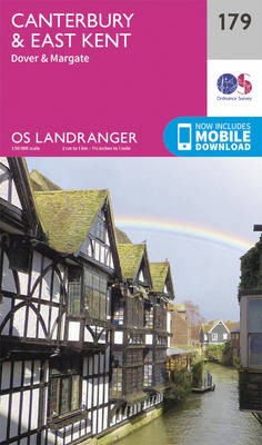
- Canterbury, East Kent, Dover & Margate OS Landranger Active Map 179 (waterproof)
- Eastern Kent with Canterbury, Dover and Margate, including sections of the North Downs Way and the E2 and E9 European Long-Distance Paths, on a waterproof and tear-resistant OS Active version of map No. 179 from the Ordnance Survey’s Landranger series at 1:50,000, with contoured and GPS compatible topographic mapping plus tourist... Read more
- Also available from:
- The Book Depository, United Kingdom

United Kingdom
- Kettering, Corby, Market Harborough & Stamford OS Landranger Active Map 141 (waterproof)
- The area around Kettering, Corby, Market Harborough and Stamford, including Rockingham Forest and part of the E2 European Long-distance Path, on a waterproof and tear-resistant OS Active version of map No. 141 from the Ordnance Survey’s Landranger series at 1:50,000, with contoured and GPS compatible topographic mapping plus tourist... Read more
- Also available from:
- The Book Depository, United Kingdom

United Kingdom
- Cheviot Hills - Jedburgh & Wooler OS Explorer Map OL16 (paper)
- The Cheviot Hills on a detailed topographic and GPS compatible map OL16, paper version, from the Ordnance Survey’s 1:25,000 Explorer series. Coverage includes Jedburgh, Woolmer, part of the Northumberland National Park, the peaks of The Cheviot, Corby Pike, Cold Law, Scrathy Holes and Windy Gyle, Catcleugh Reservoir, sections of the Pennine Way... Read more
- Also available from:
- The Book Depository, United Kingdom
- De Zwerver, Netherlands

United Kingdom
- Canterbury, East Kent, Dover & Margate OS Landranger Map 179 (paper)
- Eastern Kent with Canterbury, Dover and Margate, including sections of the North Downs Way and the E2 and E9 European Long-Distance Paths, on a paper version of map No. 179 from the Ordnance Survey’s Landranger series at 1:50,000, with contoured and GPS compatible topographic mapping plus tourist information.MOBILE DOWNLOADS: As well as the... Read more
- Also available from:
- The Book Depository, United Kingdom
- De Zwerver, Netherlands

United Kingdom
- Peterborough, Market Deeping & Chatteris OS Landranger Active Map 142 (waterproof)
- The area around Peterborough, Market Deeping and Chatteris, including the Fens of the North and Middle Levels with part of the E2 European Long-distance Path, on a waterproof and tear-resistant OS Active version of map No. 142 from the Ordnance Survey’s Landranger series at 1:50,000, with contoured and GPS compatible topographic mapping plus... Read more
- Also available from:
- The Book Depository, United Kingdom
Maps

United Kingdom
- Luxembourg North
- One of two topographic survey maps of Luxembourg at 1:50,000, with contours at 10-metres intervals and additional relief shading. An overprint highlights long-distance footpaths, including the GR5 (E-2), cycle routes, and various places of interest, including campsites. The map covers an area of approximately 53 x 43 km / 33 x 27 miles. Map... Read more

United Kingdom
- Luxembourg South
- One of two topographic survey maps of Luxembourg at 1:50,000, with contours at 10-metres intervals and additional relief shading. An overprint highlights long-distance footpaths, including the GR5 (E-2), cycle routes, and various places of interest, including campsites. The map covers an area of approximately 53 x 43 km / 33 x 27 miles. Map... Read more


