Stanfords
United Kingdom
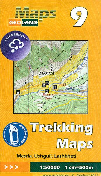
- Mestia - Ushguli - Lashkheti Geoland 9 WATERPROOF
- Mestia - Ushguli - Lashkheti area of the Caucasus Mountains in Georgia at 1:50,000 on a double-sided, contoured and GPS compatible map from Geoplan, with an overprint providing tourist information including local accommodation and sights. This is the WATERPROOF & TEAR-RESISTANT edition of the map, which is also available in a paper version.Maps... Read more

Stanfords
United Kingdom
- Bahundada
- Bahundada, sheet no. 2884-10, in the topographic survey of Nepal at 1:50,000 published by the Nepali Government in the late 1990s and early 2000s and produced from remote sensing data by Finnish cartographers as part of that country’s international aid program. The maps cover 15’ x 15’ quadrangles.IMPORTANT – PLEASE NOTE BEFORE ORDERING:... Read more

Stanfords
United Kingdom
- Busen Region - South Georgia BAS Wall Map
- South Georgia and its offshore islands in the South Atlantic presented by the British Antarctic Survey on a double-sided map combining topographic mapping of the whole island at 1:200,000 scale and detailed topographic mapping of the route of Shackleton’s crossing in May 1916 at 1:40,000 scale.On one side is a map presenting the topography by... Read more

Stanfords
United Kingdom
- Nepal Survey 1:25,000 Sheet 2883 11D (Patichaur)
- Koban, sheet no. 2883-07, in the topographic survey of Nepal at 1:50,000 published by the Nepali Government in the late 1990s and early 2000s and produced from remote sensing data by Finnish cartographers as part of that country’s international aid program. The maps cover 15’ x 15’ quadrangles.IMPORTANT – PLEASE NOTE BEFORE ORDERING:... Read more
Stanfords
United Kingdom
- Jomson
- Jomson, sheet no. 2883-03, in the topographic survey of Nepal at 1:50,000 published by the Nepali Government in the late 1990s and early 2000s and produced from remote sensing data by Finnish cartographers as part of that country’s international aid program. The maps cover 15’ x 15’ quadrangles.IMPORTANT – PLEASE NOTE BEFORE ORDERING:... Read more
Stanfords
United Kingdom
- Salpa Bhanjyang - Baksila
- Salpa Bhanjyang - Baksila, sheet no. 2786-12, in the topographic survey of Nepal at 1:50,000 published by the Nepali Government in the late 1990s and early 2000s and produced from remote sensing data by Finnish cartographers as part of that country’s international aid program. The maps cover 15’ x 15’ quadrangles.IMPORTANT – PLEASE NOTE BEFORE... Read more
Stanfords
United Kingdom
- Gurjakhani
- Gurjakhani, sheet no. 2883-05, in the topographic survey of Nepal at 1:50,000 published by the Nepali Government in the late 1990s and early 2000s and produced from remote sensing data by Finnish cartographers as part of that country’s international aid program. The maps cover 15’ x 15’ quadrangles.IMPORTANT – PLEASE NOTE BEFORE ORDERING:... Read more
Stanfords
United Kingdom
- Lantan (2885 15)
- Upper Langtang Valley, sheet no. 2885-15, in the topographic survey of Nepal at 1:50,000 published by the Nepali Government in the late 1990s and early 2000s and produced from remote sensing data by Finnish cartographers as part of that country’s international aid program. The maps cover 15’ x 15’ quadrangles.IMPORTANT – PLEASE NOTE BEFORE... Read more
Stanfords
United Kingdom
- Dhime
- Dhime, sheet no. 2882-01, in the topographic survey of Nepal at 1:50,000 published by the Nepali Government in the late 1990s and early 2000s and produced from remote sensing data by Finnish cartographers as part of that country’s international aid program. The maps cover 15’ x 15’ quadrangles.IMPORTANT – PLEASE NOTE BEFORE ORDERING:... Read more
Stanfords
United Kingdom
- Arughat
- Arughat, sheet no. 2884-16, in the topographic survey of Nepal at 1:50,000 published by the Nepali Government in the late 1990s and early 2000s and produced from remote sensing data by Finnish cartographers as part of that country’s international aid program. The maps cover 15’ x 15’ quadrangles.IMPORTANT – PLEASE NOTE BEFORE ORDERING:... Read more
Stanfords
United Kingdom
- Lapchegau
- Lapchgau, sheet no. 2886-13, in the topographic survey of Nepal at 1:50,000 published by the Nepali Government in the late 1990s and early 2000s and produced from remote sensing data by Finnish cartographers as part of that country’s international aid program. The maps cover 15’ x 15’ quadrangles.IMPORTANT – PLEASE NOTE BEFORE ORDERING:... Read more
Stanfords
United Kingdom
- Khalanga Baja (Darchula)
- Khalanga Baja (Darchula), sheet no. 2980-03 / 3080-15, in the topographic survey of Nepal at 1:50,000 published by the Nepali Government in the late 1990s and early 2000s and produced from remote sensing data by Finnish cartographers as part of that country’s international aid program. The maps cover 15’ x 15’ quadrangles.IMPORTANT – PLEASE... Read more
Stanfords
United Kingdom
- Nile
- Nile, sheet no. 2885-05, in the topographic survey of Nepal at 1:50,000 published by the Nepali Government in the late 1990s and early 2000s and produced from remote sensing data by Finnish cartographers as part of that country’s international aid program. The maps cover 15’ x 15’ quadrangles.IMPORTANT – PLEASE NOTE BEFORE ORDERING:... Read more
Stanfords
United Kingdom
- Dattu
- Dattu, sheet no. 2980-02, in the topographic survey of Nepal at 1:50,000 published by the Nepali Government in the late 1990s and early 2000s and produced from remote sensing data by Finnish cartographers as part of that country’s international aid program. The maps cover 15’ x 15’ quadrangles.IMPORTANT – PLEASE NOTE BEFORE ORDERING:... Read more

Stanfords
United Kingdom
- Barisakho - Roshka - Juta - Asa Gorge Geoland 3 WATERPROOF
- Barisakho - Roshka - Juta - Asa Gorge area of the Caucasus Mountains in Georgia at 1:50,000 on a double-sided, contoured and GPS compatible map from Geoplan, with an overprint providing tourist information including local accommodation and sights. This is the WATERPROOF & TEAR-RESISTANT edition of the map, which is also available in a paper... Read more