De Zwerver
Netherlands
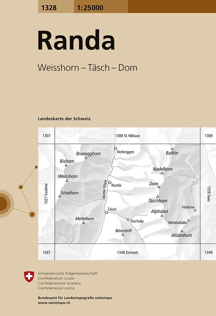
- Wandelkaart - Topografische kaart 1328 Randa | Swisstopo
- Map No. 1328, Randa, in the topographic survey of Switzerland at 1:25,000 from Swisstopo. The map covers the central section of the Mattertal from just north of Zermatt to Herbriggen, and extends west to include Weisshorn and eastwards across the Mischabel range with Dom to outskirts of Saas Fee.Swiss topographic survey at 1:25,000 covers the... Read more

De Zwerver
Netherlands

De Zwerver
Netherlands
De Zwerver
Netherlands

De Zwerver
Netherlands

De Zwerver
Netherlands
- Wandelkaart 19 Asti, Alba, Acqui terme | IGC - Istituto Geografico Centrale
- Asti - Alba - Acqui Terme area in a series contoured hiking maps at 1:50,000 with local trails, long-distance footpaths, mountain accommodation, etc. from the Turin based Istituto Geografico Centrale.Maps in this series have contours at 50m intervals, enhanced by shading and graphic relief. An overprint highlights local footpaths and... Read more
De Zwerver
Netherlands
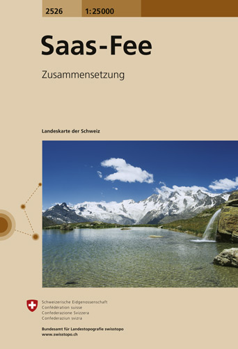
- Wandelkaart - Topografische kaart 2526 Saas - Fee | Swisstopo
- Map No. 2526, Saas-Fee, in the topographic survey of Switzerland at 1:25,000 from Swisstopo, covering the central part of the Mischabel range and both sides of the two adjoining valleys: the Mattertal between Zermatt and St Niklaus and the Saastal from north of Saas-Balen to the Mattmark Reservoir. Please note: Zermatt is at the southern edge... Read more

De Zwerver
Netherlands
- Wandelkaart 07 Valli Maira, grana e stura | IGC - Istituto Geografico Centrale
- Maira, Grana and Stura Valleys, map no. 7, in a series contoured hiking maps at 1:50,000 with local trails, long-distance footpaths, mountain accommodation, etc. from the Turin based Istituto Geografico Centrale covering the Italian Alps and Piedmont, the lakes and northern Lombardy, and the Italian Riviera.The maps have contours at 50m... Read more

De Zwerver
Netherlands
- Wandelkaart 24 Il Cuneese - Cuneo | IGC - Istituto Geografico Centrale
- Il Cuneese, map no. 24, in a series contoured hiking maps at 1:50,000 with local trails, long-distance footpaths, mountain accommodation, etc. from the Turin based Istituto Geografico Centrale covering the Italian Alps and Piedmont, the lakes and northern Lombardy, and the Italian Riviera.The maps have contours at 50m intervals, enhanced by... Read more
.jpg)
De Zwerver
Netherlands
De Zwerver
Netherlands
De Zwerver
Netherlands

De Zwerver
Netherlands

De Zwerver
Netherlands
De Zwerver
Netherlands