New Jersey
Description
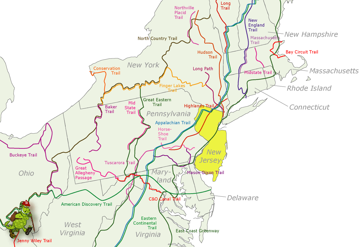
New Jersey borders on the Atlantic. This state is very populated. Hiking is best in the mountainous northern part, with several state parks and forests. Here are 72 miles of the Appalachian Trail.
The Highlands Trail is supposed to connect New Jersey to New York, Pennsylvania and Connecticut, 150 miles.
Another important trail is the Long Path, 326 miles, also in the state of New York.
The Great Eastern Trail, East Coast Greenway and Eastern Continental Trail run through New Jersey.
Map
Trails in this state
Links
Facts
Reports
Guides and maps
Lodging
Organisations
Tour operators
GPS
Other
Books

Stanfords
United Kingdom
2021
United Kingdom
2021
- DK Eyewitness Japan
- Konnichiwa from one of the most fascinating countries on earth.Whether you want to see cherry blossoms in Kyoto, speed through the countryside aboard a shinkansen, or shop til you drop in futuristic Shibuya, your DK Eyewitness travel guide makes sure you experience all Japan has to offer.Japan is a land of contrast - think tranquil zen gardens... Read more

Stanfords
United Kingdom
United Kingdom
- Algarve Marco Polo Pocket Travel Guide 2018 - with pull out map
- Marco Polo Pocket Guide Algarve: the Travel Guide with Insider Tips Explore the Algarve with this handy, pocket-sized, authoritative guide, packed with Insider Tips. Discover boutique hotels, authentic restaurants, the region`s trendiest places, and get tips on shopping and what to do on a limited budget. There are plenty of ideas for travel... Read more

Stanfords
United Kingdom
United Kingdom
- Frommer`s Rome day by day
- Map your own adventure. Rome Day by Day is the perfect guide for travelers determined to know the top places to visit and the best way to see ”Roma.” It`s written by noted travel journalist and long-time Italy resident Elizabeth Heath. She knows the city as only a local can. Packed with color photos, this bestselling guide outlines dozens of... Read more

Stanfords
United Kingdom
United Kingdom
- DK Eyewitness Madrid
- Welcome to Spain`s cultural epicentre.Whether you want to admire the elegance of the Palacio Real, contemplate the creations of Dali`s bizarre genius or enjoy the nightlife in a city that never sleeps, your DK Eyewitness travel guide makes sure you experience all that Madrid has to offerInspiration awaits around Madrid`s every corner: Spain`s... Read more

Stanfords
United Kingdom
United Kingdom
- DK Eyewitness Berlin
- Discover Berlin - a cosmopolitan capital with a vibrant spirit.Whether you want to get cultural on Museum Island, explore Berlin`s complex history at Checkpoint Charlie, walk in the footsteps of royalty at Schloss Charlottenburg, or sample a tantalizing array of street food from around the globe, your DK Eyewitness travel guide makes it easy to... Read more

Stanfords
United Kingdom
United Kingdom
- DK Eyewitness Travel Guide Spain
- Your journey starts here. Featuring DK`s much-loved maps and illustrations, walks and information, plus all new, full-colour photography, this 100% updated guide to Spain brings you the best of this sensational country in a brand-new, lightweight format.What`s inside?- full-colour photography, hand-drawnillustrations, and maps throughout-... Read more

Stanfords
United Kingdom
United Kingdom
- DK Eyewitness Travel Guide Denmark
- Discover Denmark with this essential travel guide, designed to help you create your own unique trip and to transport you to this beautiful country before you`ve even packed your case. Cycle Copenhagen`s picturesque streets, explore the rugged coastline of Bornholm, swig craft beer in Aarhus or follow in the footsteps of Vikings in Viborg and... Read more

Stanfords
United Kingdom
United Kingdom
- Walking Berlin: The Best of the City
- See the best of Berlin with this streamlined walking guide, complete with 15 step-by-step itineraries and maps to help you explore the city like a pro and navigate like a local. Created in a handy, take-along format, this guide is written by a seasoned travel writer to help conjure the spirit of the place in elegant text enhanced by National... Read more

Stanfords
United Kingdom
United Kingdom
- DK Eyewitness Florida
- Welcome to the Sunshine StateWhether you want to visit the Mission Control Room at the Kennedy Space Center, take an airboat ride in the Everglades or discover the historic Coral Gables, your DK Eyewitness travel guide makes sure you experience all that Florida has to offer.Florida is known for its sun-kissed beaches and magical theme parks,... Read more

Stanfords
United Kingdom
United Kingdom
- DK Eyewitness Travel Guide Costa Rica
- Your journey starts here. We`ve reimagined and updated our iconic DK Eyewitness travel guides. This brand new Costa Rica guide, now in a lightweight format, has been expertly curated with all new photography plus DK`s much-loved illustrations and maps. - Gorgeous, all-new colour photography so you can imagine yourself there- Reasons to love... Read more

Stanfords
United Kingdom
2011
United Kingdom
2011
- Skye & The Western Isles
- Skye & the Western Isles is a fully revised new edition of the only comprehensive guide to Scotland`s Western Isles, which include Skye, Lewis, Harris, Uist, Iona, Jura, Islay and Arran. These enchanting islands reward the visitor with a rich variety of terrain and wildlife from the stark beauty of the Cuillin mountains of Skye to the raging... Read more

Stanfords
United Kingdom
United Kingdom
- London`s Secrets: Bizarre & Curious
- London is a city with an abundance of bizarre and curious places and stories, being ancient, vast and in a constant state of regeneration. Newcomers have, of course, a wealth of world-famous attractions to keep them occupied for a month of Sundays, which are more than adequately covered in a plethora of standard guidebooks. What London`s... Read more

Stanfords
United Kingdom
United Kingdom
- DK Eyewitness Greece: Athens and the Mainland
- Mainland Greece promises incredible ancient relics, inspiring cities, idyllic beaches, and mountains steeped in myth and legend.Whether you want to watch the sun sink behind the marble columns of the Parthenon in Athens, visit iconic archaeological sites such as Delphi and Olympia, or simply soak up the sun on the sandy beaches of Halkidiki,... Read more

Stanfords
United Kingdom
United Kingdom
- Azores Tour & Trail Super-Durable Map
- For the best adventures, use the best map. Azores Tour & Trail Super-Durable Map is the most detailed, accurate, toughest, large scale map of these 9 islands that you can buy. Super-Durable Maps now come with a 2 year adventurous use wear and tear guarantee, see Discovery Walking Guides website for details. 1:60,000 scale for each island, Sao... Read more

Stanfords
United Kingdom
United Kingdom
- DK Eyewitness Northern Spain
- Explore wild mountain terrain, vibrant cities and romantic coastline.Whether you want to trek the dramatic peaks of the Picos de Europa, appreciate contemporary art at Museo Guggenheim or hop from bar to bar in the side streets of San Sebastian, your DK Eyewitness travel guide makes sure you experience all that Northern Spain has to offer.Our... Read more
Maps
Stanfords
United Kingdom
United Kingdom
- Nepal Survey 1:25,000 Sheet 2883 11B (Tatopani)
- Koban, sheet no. 2883-07, in the topographic survey of Nepal at 1:50,000 published by the Nepali Government in the late 1990s and early 2000s and produced from remote sensing data by Finnish cartographers as part of that country’s international aid program. The maps cover 15’ x 15’ quadrangles.IMPORTANT – PLEASE NOTE BEFORE ORDERING:... Read more

Stanfords
United Kingdom
United Kingdom
- Europe High 5 Edition Camping Atlas
- The first physical atlas with direct access to useful additional information from the InternetThe entirety of Europe on 432 pages in a scale of 1:800,000 clearly presented, including lots more travel information:- Road Companion (roadmaps) in a scale of 1:800,000, inclusive of the High 5 - Edition app technology for calling up additional travel... Read more

Stanfords
United Kingdom
United Kingdom
- Araniko Chuli
- Araniko Chuli, sheet no. 2983-11/15, in the topographic survey of Nepal at 1:50,000 published by the Nepali Government in the late 1990s and early 2000s and produced from remote sensing data by Finnish cartographers as part of that country’s international aid program. The maps cover 15’ x 15’ quadrangles.IMPORTANT – PLEASE NOTE BEFORE ORDERING:... Read more

Stanfords
United Kingdom
United Kingdom
- Mount Makalu
- Mount Makalu, sheet no. 2787-01, in the topographic survey of Nepal at 1:50,000 published by the Nepali Government in the late 1990s and early 2000s and produced from remote sensing data by Finnish cartographers as part of that country’s international aid program. The maps cover 15’ x 15’ quadrangles.IMPORTANT – PLEASE NOTE BEFORE ORDERING:... Read more

Stanfords
United Kingdom
2021
United Kingdom
2021
- Belgium NGI Long-Distance Trails Map
- Belgium: Long-distance Footpaths Map at 1:300,000 from Nationaal Geografisch Instituut/Institut Géographique National, the country’s national survey organization, showing the network of the waymarked long-distance GR routes.The map uses as its base a road map of the country, with an overprint highlighting the network of Belgium’s long-distance... Read more

Stanfords
United Kingdom
United Kingdom
- Chhedhul Gumba
- Chhedhul Gumba, sheet no. 2883-01, in the topographic survey of Nepal at 1:50,000 published by the Nepali Government in the late 1990s and early 2000s and produced from remote sensing data by Finnish cartographers as part of that country’s international aid program. The maps cover 15’ x 15’ quadrangles.IMPORTANT – PLEASE NOTE BEFORE ORDERING:... Read more

Stanfords
United Kingdom
United Kingdom
- Gaurishankar Himal
- Gaurishankar Himal, sheet no. 2786-02, in the topographic survey of Nepal at 1:50,000 published by the Nepali Government in the late 1990s and early 2000s and produced from remote sensing data by Finnish cartographers as part of that country’s international aid program. The maps cover 15’ x 15’ quadrangles.IMPORTANT – PLEASE NOTE BEFORE... Read more

Stanfords
United Kingdom
United Kingdom
- Chainpur
- Chainpur, sheet no. 2981-05, in the topographic survey of Nepal at 1:50,000 published by the Nepali Government in the late 1990s and early 2000s and produced from remote sensing data by Finnish cartographers as part of that country’s international aid program. The maps cover 15’ x 15’ quadrangles.IMPORTANT – PLEASE NOTE BEFORE ORDERING:... Read more

Stanfords
United Kingdom
United Kingdom
- Kalanga Bajar (Jumla)
- Kalanga Bajar (Jumla), sheet no. 2982-09, in the topographic survey of Nepal at 1:50,000 published by the Nepali Government in the late 1990s and early 2000s and produced from remote sensing data by Finnish cartographers as part of that country’s international aid program. The maps cover 15’ x 15’ quadrangles.IMPORTANT – PLEASE NOTE BEFORE... Read more

Stanfords
United Kingdom
United Kingdom
- Rasuwagadhi
- Rasuwagadhi, sheet no. 2885-10, in the topographic survey of Nepal at 1:50,000 published by the Nepali Government in the late 1990s and early 2000s and produced from remote sensing data by Finnish cartographers as part of that country’s international aid program. The maps cover 15’ x 15’ quadrangles.IMPORTANT – PLEASE NOTE BEFORE ORDERING:... Read more

Stanfords
United Kingdom
United Kingdom
- Talkot
- Talkot, sheet no. 2981-06, in the topographic survey of Nepal at 1:50,000 published by the Nepali Government in the late 1990s and early 2000s and produced from remote sensing data by Finnish cartographers as part of that country’s international aid program. The maps cover 15’ x 15’ quadrangles.IMPORTANT – PLEASE NOTE BEFORE ORDERING:... Read more

Stanfords
United Kingdom
United Kingdom
- Mt. Cho Oyu - Pasan Lhamu Chuli
- Mt Cho Oyu - Pasan lhamu Chuli, sheet no. 2886-15, in the topographic survey of Nepal at 1:50,000 published by the Nepali Government in the late 1990s and early 2000s and produced from remote sensing data by Finnish cartographers as part of that country’s international aid program. The maps cover 15’ x 15’ quadrangles.IMPORTANT – PLEASE NOTE... Read more

Stanfords
United Kingdom
United Kingdom
- Bagarchhap
- Bagarchhap, sheet no. 2884-06, in the topographic survey of Nepal at 1:50,000 published by the Nepali Government in the late 1990s and early 2000s and produced from remote sensing data by Finnish cartographers as part of that country’s international aid program. The maps cover 15’ x 15’ quadrangles.IMPORTANT – PLEASE NOTE BEFORE ORDERING:... Read more
Stanfords
United Kingdom
United Kingdom
- Nepal Survey 1:25,000 Sheet 2883 11D (Patichaur)
- Koban, sheet no. 2883-07, in the topographic survey of Nepal at 1:50,000 published by the Nepali Government in the late 1990s and early 2000s and produced from remote sensing data by Finnish cartographers as part of that country’s international aid program. The maps cover 15’ x 15’ quadrangles.IMPORTANT – PLEASE NOTE BEFORE ORDERING:... Read more

Stanfords
United Kingdom
United Kingdom
- Cycling the Canal de la Garonne: From Bordeaux to Toulouse
- This guidebook presents a cycle ride along the Canal de la Garonne in the south of France. The 290km route is covered in 7 stages from bustling Bordeaux to the splendid rose city of Toulouse, with a 135km excursion from to Lacanau on the Atlantic coast. Optional side trips explore the countryside and historical towns and villages, including... Read more


