
Paris
Description
Capital of France.
Links
Facts
Reports
Guides and maps
Lodging
Organisations
Tour operators
GPS
Other
Books

Stanfords
United Kingdom
United Kingdom
- Walking on the Ceiling
- ”[Savas] writes with both sensuality and coolness, as if determined to find a rational explanation for the irrationality of existence...” The New York Times”I fell in love with this book.” Katie Kitamura, author of `A Separation`A mesmerizing novel set in Paris and a changing Istanbul, about a young Turkish woman grappling with her past and her... Read more

Stanfords
United Kingdom
United Kingdom
- Villes, Parcs et Forêts des Hauts-de-Seine à pied VI92
- Villes, parcs et forêts des Hauts-de-Seine à pied, FFRP topo-guide Ref. No. VI92, with 25 walks in the western and south-western suburbs of Paris, presented with their descriptions cross-referenced to the accompanying colour maps. Current edition of this title was published in May 2011.To see all the FFRP guides to walks in the French capital ... Read more
Stanfords
United Kingdom
2020
United Kingdom
2020
- Les Environs de Paris à pied RE01
- Les Environs de Paris à pied, FFRP topo-guide Ref. No. RE01, with 50 day walks of varying length and difficulty in the environs of the French capital, including in the forests of Fontainebleau and Rambouillet, etc. Each walk is presented on a separate colour extract from IGN’s topographic survey of France at 1:25,000, with its description... Read more

Stanfords
United Kingdom
United Kingdom
- Paris Step by Step Insight Guide (ed.1) SUPERCEDED
- See the Sunrise in Montmartre, have Coffee in a Classic Cafe, Cycle up the Canal St-Martin, Relax in the Tuileries and Tour in a Classic Car; take a fresh approach to Paris with this ”Step by Step” guide, part of a brand new, stylishly designed series from Insight Guides. Lavishly illustrated in full colour, this book features 20 irresistible... Read more

Stanfords
United Kingdom
United Kingdom
- Paris Adventure Walks Map
- Central Paris on a street plan highlighting recommended sightseeing walks and the city’s numerous places of interest, including attractions specially selected to entertain children.On one side is a plan of central Paris: roughly from Arc de Triomphe and the Eiffel Tower to the Bastille, and from Gare du Nord to the Luxembourg Gardens. Metro/RER... Read more
Stanfords
United Kingdom
2018
United Kingdom
2018
- Paris à pied
- Paris à pied, FFRP topo-guide Ref. No. VI75, with three routes across Paris, highlighted on extracts from a street plan of the city and with descriptions of buildings and other locations illustrated with numerous colour photos. The three routes not only link some of the French capital’s best loved sights but also take the visitors past or... Read more

Stanfords
United Kingdom
United Kingdom
- Rick Steves Best of France (Third Edition)
- Hit France`s can`t-miss art, sights, and bites in two weeks or less with Rick Steves Best of France! Inside you`ll find:Strategic advice from Rick Steves on what`s worth your time and moneyShort itineraries covering the best of Paris, Normandy, the Loire, Dordogne, Provence, the French Riviera, and Burgundy, including Versailles, Nice, the... Read more
Stanfords
United Kingdom
2020
United Kingdom
2020
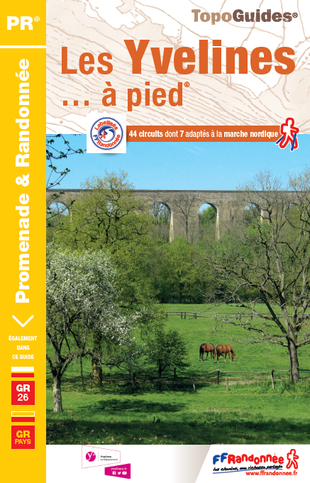
- Les Yvelines à pied D078
- Les Yvelines à pied, FFRP topo-guide Ref. No. D078, with 43 day walks of varying length and difficulty in the department of Les Yvelines. The guide, which also includes two GR de Pays routes totaling 150 kms, covers an area west and south-west of Paris with Versailles, Saint-Germain-en-Laye and the forest of Rambouillet. Each walk is presented... Read more
- Also available from:
- De Zwerver, Netherlands

Stanfords
United Kingdom
United Kingdom
- Paris Insight City Guide SUPERCEDED
- The ”Insight City Guides” have just got better! With more detailed coverage spanning over 350 pages and over double the number of photos, they provide a highly visual introduction to the city. 2 street atlases provide extra clarity and easy orientation - one indexed atlas locates hotels and restaurants, and a second plots principal sites and... Read more

Stanfords
United Kingdom
United Kingdom
- Paris Walks
- This updated 3rd edition of this delightful walking guide whose unique selling point is walking routes on `bird`s eye view` (isometric) mapping. Not just this, but the walks are informative and fun. Exploring Paris with this guide is like being taken by a friend who knows all the best restaurants, shops and attractions. It will introduce not... Read more

Stanfords
United Kingdom
United Kingdom
- DK Eyewitness Paris
- Discover Paris - a city synonymous with art, fashion, gastronomy, and culture.Whether you want to be awed by iconic landmarks, lose yourself in the Louvre, or stroll along the Seine, your DK Eyewitness travel guide makes sure you experience all that Paris has to offer.Paris is a treasure trove of things to see and do. Packed full of... Read more

Stanfords
United Kingdom
United Kingdom
- The Flaneur
- A flaneur is a stroller, a loiterer, someone who ambles without apparent purpose but is secretly attuned to the history of the streets he walks - and is in covert search of adventure, aesthetic or erotic. Acclaimed writer Edmund White, who lived in Paris for sixteen years, wanders through the avenues and along the quays, into parts of the city... Read more

Stanfords
United Kingdom
United Kingdom
- Rick Steves Pocket Paris (Fourth Edition)
- Make the most of every day and every dollar with Rick Steves! This colorful, compact guidebook is perfect for spending a week or less in Paris: City walks and tours: Six detailed tours and walks showcase Paris`s essential sights, including the Louvre, the Orsay Museum, Notre-Dame, a stroll along the Left Bank, and moreRick`s strategic advice on... Read more
Stanfords
United Kingdom
2019
United Kingdom
2019
- La Seine-et-Marne a Pied D077
- Seine-et-Marne à pied, FFRP topo-guide Ref. No. D077, with 60 day walks of varying length and difficulty in the Department of Seine-et-Marne just east of Paris, including a tour of the massif and the forest of Fontainebleau. The area covered by the guide also includes Vaux-le-Vicomte, the Commanderie des Templiers in Coulommiers, Meaux,... Read more

Stanfords
United Kingdom
2021
United Kingdom
2021
- DK Eyewitness France
- Discover France`s special je ne sais quoiWhether you want to visit fairytale chateaux, stroll amid rolling fields of blossoming lavender or learn what makes a noble vintage, your DK Eyewitness travel guide makes sure you experience all that France has to offer.Few countries capture the imagination quite like France. The world-famous cuisine is... Read more
Maps

Stanfords
United Kingdom
United Kingdom
- Parcs et jardins de Paris à pied FFRP Topo-guide No. VI12
- Parcs et jardins de Paris à pied, FFRP topo-guide Ref. No.VI12, with 27 routes to enjoy the green areas of the capital: in the city’s famous parks including the Parc Montsouris, Parc Monceau, Buttes-Chaumont or the Luxembourg Gardens, in the smaller green spaces such as Jardins-Martin-Lutter-King, in the Père Lachaise Cemetery, in the Bois de... Read more

Stanfords
United Kingdom
United Kingdom
- Paris Blay-Foldex Street Plan
- This title is part of an extensive series of street plans of French towns from Blay-Foldex, the country’s largest, oldest and most experienced publisher of urban mapping.Blay plans include outer suburbs and, where appropriate, adjoining localities forming part of the urban agglomeration and provide brief descriptions of the town’s main sights,... Read more

Stanfords
United Kingdom
United Kingdom
- La Véloscénie: Paris to Mont-Saint-Michel Cycle Route (434km)
- La Véloscénie: de Paris au Mont-Saint-Michel, an A5 spiral-bound cycling guide from Itinerance a Vélo showing the 434km-long route from the capital via Chartres and Alençon on 60 panels at 1:80,000 with contoured mapping from the IGN, plus contact addresses for recommended accommodation, cycle shops, etc. The Paris to Chartres stage also... Read more

Stanfords
United Kingdom
United Kingdom
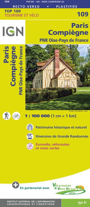
- Paris - Compiegne - PNR Oise-Pays de France IGN TOP100 109
- Discover the new double-sided laminated edition of TOP100 road maps of France from the Institut Géographique National (IGN); exceptionally detailed, contoured road maps which include the cycle paths and greenways of the AF3V (French Association for the Development of Cycle Paths and Greenways), ideal for exploring the French countryside by car,... Read more
- Also available from:
- De Zwerver, Netherlands
Stanfords
United Kingdom
United Kingdom
- Republic of Congo IGN Road Map 85015
- Congo (Brazaville) on a road map from the IGN in Paris, with relief shading and colouring/graphics indicating different types of vegetaion and terrain: forest, grassland, marches, areas liable to flooding. Road and rail connections are shown, with a separate distance table between main centres of population. A large diagram shows the... Read more

Stanfords
United Kingdom
United Kingdom
- Paris IGN WATERPROOF Street Map
- IGN’s street plan of Paris presented on a more handy size sheet and printed on light, waterproof and tear resistant synthetic paper. The plan is double-sided, with hardly any overlap between the two sides, and covers the city within the Boulevard Périphérique.Main traffic arteries are highlighted and one way streets are marked. Also shown are... Read more

Stanfords
United Kingdom
United Kingdom
- The Western Front
- Double-sided map of the Western Front across northern France and Belgium during World War I, presenting the battlefields in a series of map panels annotated with present day monuments and/or front lines and directions of various offensives, plus extensive informative additional notes and numerous photos.On one side separate panels show the main... Read more

Stanfords
United Kingdom
United Kingdom
- France Chamina Edition Greenways and Cycle Routes Atlas
- Guarantee of quality and reliability, the Atlas France of greenways & cycle routes Chamina is enriched this year by more than 1,000 km of cycle route: 2 new cycle routes (The Flow Vélo and the EuroVelo 4 - Tour de Manche) , as well as the updating of the extensive routes such as the ViaRhôna, the Vélo Francette, the EuroVelo 6 and the... Read more

Stanfords
United Kingdom
United Kingdom
- Canal de l`Ourcq and the Canals of Paris
- Folded overview map at 1:75,000 of the Canal de l`Ourcq and the Marne, plus the Seine and the canals of within Paris. The map shows various facilities and hazards along the route, as described below, with additional enlargements for more complicated sections, including the basins at la Villette and the Arsenal. Also included are tables with... Read more

Stanfords
United Kingdom
United Kingdom
- Paris Michelin Pocket Plan
- Discover Paris by foot, car or bike using Michelin Paris Pocket City Plan (scale 1:20,000). In addition to Michelin`s clear and accurate mapping, this pocket city plan will help you explore and navigate across Paris thanks to its full index, its comprehensive key showing places of interest and tourist attractions, as well as practical... Read more

Stanfords
United Kingdom
United Kingdom
- Djibouti IGN 85004
- Djibouti at 1:200,000 on an indexed map from the Institut Géographique National in Paris showing both the country’s road and rail networks and its physical geography, plus an enlargement of Djibouti City with its international airport.Road classification indicates unsurfaced routes and includes 4WD trails and tracks. Intermediate distances are... Read more

Stanfords
United Kingdom
United Kingdom
- Paris Michelin Transport Map
- Replaces both the Paris Transport (51) & Paris Tourism (53) Maps.Discover Paris by foot, car or bike using Michelin Paris City Plan (with Street index, scale 1:20,000). In addition to Michelin`s clear and accurate mapping, this city plan will help you explore and navigate across Paris` different districts thanks to its full index, its... Read more

Stanfords
United Kingdom
United Kingdom
- Paris - Foret de Meudon - Foret de Fausses Reposes IGN 2314OT
- Topographic survey of France at 1:25,000 in IGN`s excellent TOP25 / Série Bleue series. All the maps are GPS compatible, with a 1km UTM grid plus latitude and longitude lines at 5’ intervals. Contours are at 5m intervals except for mountainous areas where the maps have contours at 10m intervals, vividly enhanced by hill shading and graphics for... Read more

Stanfords
United Kingdom
United Kingdom
- France IGN Road Map 901
- A single sided detailed IGN road map of France at a scale of 1:1 million with place name index of major towns. There is also an enlargement of Paris and the area surrounding. Details of toll roads are also given on the map, as are distances between major cities, with a multilingual legend. Read more

Stanfords
United Kingdom
2020
United Kingdom
2020
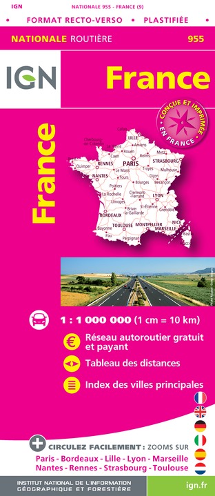
- France IGN Road Map WATERPROOF
- An laminated IGN route map of France enables you to plan your journeys across France. Includes table of distances and index of principal towns as well as map enlargements for Paris, Bordeaux, Lille, Lyon, Marseille, Nantes, Rennes, Strasbourg and Toulouse. Read more
- Also available from:
- De Zwerver, Netherlands
De Zwerver
Netherlands
2020
Netherlands
2020
- Wegenkaart - landkaart 955 Frankrijk maxi Recto Verso (geplastificeerd) | IGN - Institut Géographique National
- An laminated IGN route map of France enables you to plan your journeys across France. Includes table of distances and index of principal towns as well as map enlargements for Paris, Bordeaux, Lille, Lyon, Marseille, Nantes, Rennes, Strasbourg and Toulouse. Read more