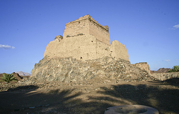
United Arab Emirates
Description
The United Arab Emirates is a federation of seven states or emirates, of which Dubai and Abu Dhabi (the largest) are probably the best known. All are located in the southeast of the Arabian Peninsula facing the Persian Gulf and the Gulf of Oman. Most of the landscape consists of arid desert plains, sand dunes, dry river beds or wadi's and the occasional oasis. Only in the northeast are the high mountains of the Western Hajar range, partly on the border with Oman.
The northeast is also the place to head for if you want to explore on foot. Well known are the Hatta pools, and the spectacular "Stairway to Heaven" which is in fact an old trail of the local Shihu tribe, winding up steeply from the Ghalilah Wadi. But there are other beautiful mountains and wadi's to explore in the mountainous emirates of Fujairah and Ras Al Khaima.
Climate in the Emirates is hot and dry year round, with highest temparatures and humidity in July and August. So always make sure you carry plenty of drinking water, and protection against the sun.
Trails
Regions
Links
Facts
Reports
Guides and maps
Lodging
Organisations
Tour operators
GPS
Other
Maps

United Kingdom
- Oman & The United Arab Emirates OUT OF PRINT
- Oman and the United Arab Emirates on a double-sided, indexed road map at 1:1,500,000 from Insight. This large map includes many places of interest and street plans of Dubai, Abu Dhabi, Doha, Muscat, Al Manama, Sur and Salalah.The network of main roads is displayed, with distinctions between main, secondary and minor roads. Markers indicate... Read more

United Kingdom
- United Arab Emirates - Dubai - Abu Dhabi Reise Know-How
- United Arab Emirates at 1:470,000 on a double-sided, waterproof and tear-resistant road map with topographic and tourist information, plus a plan of Dubai City with an enlargement of its central area and a plan central Abu Dhabi City. The map is part of Reise Know-How’s highly acclaimed World Mapping Project.The main map at 1:470,000 covers... Read more
- Also available from:
- De Zwerver, Netherlands

Netherlands
- Wegenkaart - landkaart Verenigde Arabische Emiraten, Dubai, Abu Dhabi | Reise Know-How Verlag
- United Arab Emirates at 1:470,000 on a double-sided, waterproof and tear-resistant road map with topographic and tourist information, plus a plan of Dubai City with an enlargement of its central area and a plan central Abu Dhabi City. The map is part of Reise Know-How’s highly acclaimed World Mapping Project.The main map at 1:470,000 covers... Read more

Netherlands
- Wegenkaart - landkaart Verenigde Arabische Emiraten - Persische Golf - Koeweit - Oman | Freytag & Berndt
- Vereinigte Arabische Emirate, Oman 1 : 1 600 000. Autokarte ab 10.9 EURO United Arab Emirates, Oman. Touristische Informationen. Ortsregister freytag & berndt Auto + Freizeitkarten Read more


