
Cotswolds
Description
The charm of the Cotswold lies in its stone, the yellowish sandy chalk from which the inhabitants built their homes and villages. This is only one of its outstanding features. Others are its fertile woods and grazing lands, the fine views west over the Severn Valley where the chalk hills suddenly break down. There are many neolithic and iron age forts and settlements. Exploring the Cotswolds is best done on the Cotswold Way, a National Trail. The whole of the Cotswold is Area of Outstanding Natural Beauty.
Trails in this region
Links
Facts
Reports
Guides and maps
Lodging
Organisations
Tour operators
GPS
Other
Books

Stanfords
United Kingdom
United Kingdom
- DK Eyewitness Great Britain
- Three unique nations interwoven into a rich cultural tapestry, this small island has huge character.Whether you want to tour elegant stately homes, marvel at prehistoric wonders or take a windswept walk along cliff-top paths, your DK Eyewitness travel guide makes sure you experience all that Great Britain has to offer.From the jagged peaks of... Read more

Stanfords
United Kingdom
United Kingdom
- DK Eyewitness Great Britain
- Discover Great Britain - a beautiful land rich in culture and history. Whether you want to go wild swimming in the Fairy Pools of Skye, take a windswept walk along the Jurassic Coast, or scale the heights of Snowdonia, your DK Eyewitness travel guide makes sure you experience all that Great Britain has to offer.From the jagged peaks of the... Read more

Stanfords
United Kingdom
United Kingdom
- Thames Valley - Pocket Pub Walks
- This work is a pocket-size collection of fifteen circular walks each based on a local pub serving good food. It includes routes at Dorchester, Goring, Reading, Wargrave, Cookham, Little Marlow and Eton. It includes maps and photographs. Read more

Stanfords
United Kingdom
United Kingdom
- Thames Valley - 20 Country Walks For All The Family
- An exciting new gift series of walking guides, aimed at the weekend, family walker. These small-format, portable hardback books have an attractive retro feel, with nostalgic line drawings and hand-drawn maps. Each of the 20 walks have been carefully selected to appeal to family walkers, most are circular and none are too strenuous. Each walk... Read more

Stanfords
United Kingdom
United Kingdom
- Guide to Bristol & Bath Pub Walks
- Looking for the best pub walks in and around Bristol and Bath? This is the book for you.This super-handy, pocket-sized guide features 20 circular routes varying in length from 4 to 8 miles, all of which start and finish at a top local pub.Highlights include:Beautiful coastal paths along the Severn Estuary; Spectacular views at Cheddar Gorge;... Read more

Stanfords
United Kingdom
United Kingdom
- The Big Walks of London
- The Big Walks of London by John Merrill is a guidebook to the capitals major walking routes. London has an incredible variety of walks and trails, and this guidebook presents more than twenty long walks through the city, ranging from 7 to 150 miles, and includes the Thames Path, the London Loop and the Capital Ring. Each walk section is... Read more

Stanfords
United Kingdom
2021
United Kingdom
2021
- DK Eyewitness Road Trips Great Britain
- With its idyllic market towns, romantic castle ruins and stunning natural landscapes, Great Britain is the perfect destination for a leisurely road trip. It`s yours to explore with Road Trips Great Britain, which contains 25 drives across the country, from the sweeping sandy beaches of Cornwall to the dramatic peaks of the Scottish... Read more

Stanfords
United Kingdom
United Kingdom
- River Thames & Thames Path Heron Map
- This tourist map of the River Thames and Thames Path covers from its source, just outside Kemble in Gloucestershire, to the Thames Barrier at 1:55,000, with detailed town plans of Lechlade, Oxford, Abingdon, Wallingford, Henley-on-Thames, central Reading, Windsor and Eton, Marlow and Kingston upon Thames at 1:12,500. The Thames and Severn Canal... Read more

Stanfords
United Kingdom
United Kingdom
- Cotswold Classic Walks
- Cotswold Classic Walks guide is a wonderful collection of 25 scenic, circular walks that will take you off the beaten track to discover the beautiful Cotswolds. Be prepared for some hills as you don your boots and enjoy a day or a weekend of fresh air, exercise and some much needed freedom. We give you advice on which walks are best for kids,... Read more

Stanfords
United Kingdom
2021
United Kingdom
2021
- The Rough Guide to Walks in & around London (Travel Guide with Free eBook)
- The Rough Guide to Walks in and Around LondonMake the most of your time on Earth with the ultimate travel guides.World-renowned `tell it like it is` guidebook available now with a free eBook Discover walks in and around London with this comprehensive, entertaining, `tell it like it is` Rough Guide, packed with our experts` honest and... Read more

Stanfords
United Kingdom
United Kingdom
- Maidstone, Royal Tunbridge Wells, Sevenoaks & Tonbridge OS Landranger Active Map 188 (waterproof)
- Maidstone, Tunbridge Wells and the High Weald area, including a section of the North Downs Way / E2 European Long-distance Path, on a waterproof and tear-resistant OS Active version of map No. 188 from the Ordnance Survey’s Landranger series at 1:50,000, with contoured and GPS compatible topographic mapping plus tourist information.MOBILE... Read more

Stanfords
United Kingdom
United Kingdom
- Bury St Edmunds, Sudbury & Stowmarket OS Landranger Active Map 155 (waterproof)
- Suffolk around Bury St Edmunds, Sudbury and Stowmarket, including part of the E2 European Long-distance path, on a waterproof and tear-resistant OS Active version of map No. 155 from the Ordnance Survey’s Landranger series at 1:50,000, with contoured and GPS compatible topographic mapping plus tourist information.MOBILE DOWNLOADS: As well as... Read more

Stanfords
United Kingdom
United Kingdom
- Cheltenham, Cirencester & Stow-on-the-Wold OS Landranger Active Map 163 (waterproof)
- Cheltenham and Cirencester area, including sections of the Thames Path, the Cotswold Way and the E2 European Long-distance Path, on a waterproof and tear-resistant OS Active version of map No. 163 from the Ordnance Survey’s Landranger series at 1:50,000, with contoured and GPS compatible topographic mapping plus tourist information.MOBILE... Read more

Stanfords
United Kingdom
United Kingdom
- Oxford, Chipping Norton & Bicester OS Landranger Active Map 164 (waterproof)
- Oxford area, including sections of the Thames Path and the E2 European Long-distance Path, on a waterproof and tear-resistant OS Active version of map No. 164 from the Ordnance Survey’s Landranger series at 1:50,000, with contoured and GPS compatible topographic mapping plus tourist information.MOBILE DOWNLOADS: As well as the physical edition... Read more

Stanfords
United Kingdom
United Kingdom
- North York Moors Western OS Explorer Active Map OL26 (waterproof)
- The western part of the North York Moors National Park on a detailed topographic and GPS compatible map OL26, waterproof version, from the Ordnance Survey’s 1:25,000 Explorer series. Coverage extends from Ampleforth in the south northwards to Saltburn-by-the-Sea, and from Ingleby Arncliffe to Danby, Castleton and Hutton-le-Hole, and includes... Read more
Maps

Stanfords
United Kingdom
United Kingdom
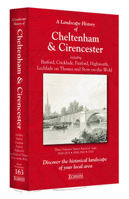
- Cheltenham and Cirencester 1919
- Map No. 163, Cheltenham and Cirencester 1919, in the Cassini Historical Series of old Ordnance Survey mapping of England and Wales at 1:50,000 in a format designed to offer a convenient comparison with the present day coverage from the OS, and most locations in three different editions. Old historical maps have been combined so that the sheet... Read more

Stanfords
United Kingdom
United Kingdom
- Cotswold Way A-Z Adventure Atlas
- The Cotswold Way Adventure Atlas, presenting the 102 miles / 163 km long hiking route between Bath and Chipping Campden on mapping at 1:25,000 in a series of handy A5 size Adventure Atlases from Geographers` A-Z Map Company with cartography from the Ordnance Survey’s Explorer series. To see other titles in this series please click on the series... Read more
Stanfords
United Kingdom
United Kingdom
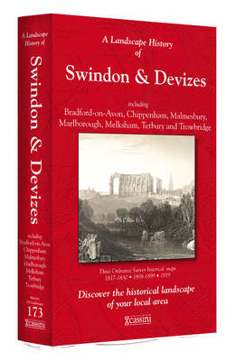
- Swindon and Devizes 1898-1899
- Map No. 173, Swindon and Devizes 1898-1899, in the Cassini Historical Series of old Ordnance Survey mapping of England and Wales at 1:50,000 in a format designed to offer a convenient comparison with the present day coverage from the OS, and most locations in three different editions. Old historical maps have been combined so that the sheet... Read more
Stanfords
United Kingdom
United Kingdom
- Cheltenham and Cirencester 1898-1900
- Map No. 163, Cheltenham and Cirencester 1898-1900, in the Cassini Historical Series of old Ordnance Survey mapping of England and Wales at 1:50,000 in a format designed to offer a convenient comparison with the present day coverage from the OS, and most locations in three different editions. Old historical maps have been combined so that the... Read more
Stanfords
United Kingdom
United Kingdom
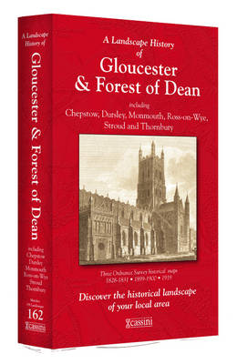
- Gloucester and the Forest of Dean 1899-1900
- Map No. 162, Gloucester and the Forest of Dean 1899-1900, in the Cassini Historical Series of old Ordnance Survey mapping of England and Wales at 1:50,000 in a format designed to offer a convenient comparison with the present day coverage from the OS, and most locations in three different editions. Old historical maps have been combined so that... Read more
Stanfords
United Kingdom
United Kingdom
- Cheltenham and Cirencester 1828-1919 (3-map set)
- Map No. 163, Cheltenham and Cirencester 1828-1919 (3-map set), in the Cassini Historical Series of old Ordnance Survey mapping of England and Wales at 1:50,000 in a format designed to offer a convenient comparison with the present day coverage from the OS, and most locations in three different editions. Old historical maps have been combined so... Read more
Stanfords
United Kingdom
United Kingdom
- Gloucester and the Forest of Dean 1818-1919 (3-map set)
- Map No. 162, Gloucester and the Forest of Dean 1818-1919 (3-map set), in the Cassini Historical Series of old Ordnance Survey mapping of England and Wales at 1:50,000 in a format designed to offer a convenient comparison with the present day coverage from the OS, and most locations in three different editions. Old historical maps have been... Read more
Stanfords
United Kingdom
United Kingdom
- Swindon and Devizes 1817-1919 (3-map set)
- Map No. 173, Swindon and Devizes 1817-1919 (3-map set), in the Cassini Historical Series of old Ordnance Survey mapping of England and Wales at 1:50,000 in a format designed to offer a convenient comparison with the present day coverage from the OS, and most locations in three different editions. Old historical maps have been combined so that... Read more
Stanfords
United Kingdom
United Kingdom
- Swindon and Devizes 1817-1830
- Map No. 173, Swindon and Devizes 1817-1830, in the Cassini Historical Series of old Ordnance Survey mapping of England and Wales at 1:50,000 in a format designed to offer a convenient comparison with the present day coverage from the OS, and most locations in three different editions. Old historical maps have been combined so that the sheet... Read more

Stanfords
United Kingdom
United Kingdom
- Luxembourg North
- One of two topographic survey maps of Luxembourg at 1:50,000, with contours at 10-metres intervals and additional relief shading. An overprint highlights long-distance footpaths, including the GR5 (E-2), cycle routes, and various places of interest, including campsites. The map covers an area of approximately 53 x 43 km / 33 x 27 miles. Map... Read more
Stanfords
United Kingdom
United Kingdom
- Gloucester and the Forest of Dean 1824-1831
- Map No. 162, Gloucester and the Forest of Dean 1824-1831, in the Cassini Historical Series of old Ordnance Survey mapping of England and Wales at 1:50,000 in a format designed to offer a convenient comparison with the present day coverage from the OS, and most locations in three different editions. Old historical maps have been combined so that... Read more

Stanfords
United Kingdom
United Kingdom
- Cycle Tours Around Oxford
- Oxford has long enjoyed a reputation as one of the most cycle-friendly cities in the country. This spiral-bound guide describes 20 wonderful bike rides in the countryside in a 30-mile radius around the city, exploring the delights of the Cotswolds, the Lambourn Downs and the Chilterns. The book contains 15 rides on networks of quiet lanes... Read more

Stanfords
United Kingdom
United Kingdom
- Luxembourg South
- One of two topographic survey maps of Luxembourg at 1:50,000, with contours at 10-metres intervals and additional relief shading. An overprint highlights long-distance footpaths, including the GR5 (E-2), cycle routes, and various places of interest, including campsites. The map covers an area of approximately 53 x 43 km / 33 x 27 miles. Map... Read more

Stanfords
United Kingdom
United Kingdom
- Cotswold Cycling Country Lanes & Traffic-Free Family Routes
- Explore the Cotswolds by bike with this laminated, waterproof Cotswolds map. With 28 circular, clearly-marked routes this easy-to-use map will help you discover the best of the Cotswolds along the quietest country lanes.The Cotswolds are ideal for the touring cyclist and day-tripper. They represent England at her very best. Long, winding lanes... Read more
Stanfords
United Kingdom
United Kingdom
- Swindon and Devizes 1919
- Map No. 173, Swindon and Devizes 1919, in the Cassini Historical Series of old Ordnance Survey mapping of England and Wales at 1:50,000 in a format designed to offer a convenient comparison with the present day coverage from the OS, and most locations in three different editions. Old historical maps have been combined so that the sheet lines... Read more