
Lake District
Description
The Lake District in northwestern England is one of the most popular hiking and holiday destinations of England. The contrast between the wild, sometimes rugged mountains, and the friendly valleys is striking. The lakes offer excellent holiday entertainment. Speaking about the Lake District, one should not forget to mention the romantic poet William Wordsworth. You may find copies of his writings in the villages.
Several long distance hikes traverse the region. The Coast to Coast Path chooses some of the best scenery. But there is much more to enjoy. The extended network of well marked trails is awaiting you.
Trails in this region
Links
Facts
Reports
Guides and maps
Lodging
Organisations
Tour operators
GPS
Other
Books

Stanfords
United Kingdom
United Kingdom
- Cumbria & the Lake District - Drive & Stroll
- On a fine day, there`s nothing quite like a drive to the country, followed by a leisurely walk and a hearty meal in a good local pub or cafe. This book contains a collection of 20 walks in Cumbria and the Lake District to help you do just that.HIGHLIGHTS INCLUDE:A gentle riverside ramble near Langwathby; The fellsides and rich woodland around... Read more

Stanfords
United Kingdom
United Kingdom
- The National Trust Book of the Countryside
- Explore the British countryside with the National Trust. No organisation knows more about the British countryside than the National Trust, the custodians of some of our most beautiful stretches of land and coastline. Drawing on their expertise, this stunningly illustrated book is a comprehensive guide to the country`s natural heritage. Part One... Read more

Stanfords
United Kingdom
United Kingdom
- Photographing The Lake District
- Photographing the Lake District (second edition) is a visitor and photo-location guidebook, and a beautiful visual record of the UNESCO World Heritage site. Perfect to plan your trip from home and to take with you on your trip.After 15,000 copies of his first edition were sold, Stuart Holmes has extensively updated his visitor and a... Read more

Stanfords
United Kingdom
United Kingdom
- A Cyclist`s Guide to the Pyrenees
- Where do you turn when you want to ride in the mountains, to follow in the wheeltracks of professional racers by climbing the famous passes of the Tour de France? There are several books and websites that highlight these renowned ascents, detailing their location, length and every little change in gradient. But how do you go about finding a... Read more

Stanfords
United Kingdom
United Kingdom
- Pub and Fell Walks Combined pub and fell walks in the Lake District
- This attractive and cleverly structured guide gives walkers ten of the finest walks combining a superb Lakeland pub with a classic fell walk in the Lake District National Park in a popular pocketable format. With clear information, an overview and introduction for each walk, expertly written numbered directions, large scale Ordnance Survey... Read more
Stanfords
United Kingdom
United Kingdom
- More Lake District
- Pathfinder (R) Guide More Lake District privides 28 more outstanding walks across England`s most mountainous region, with its balanced range of walks throughout the National Park and beyond. There are walks within easy reach of the popular centres at Ambleside, Coniston, Patterdale, Keswick and Egremont, and routes range from Mungrisdale in the... Read more

Stanfords
United Kingdom
United Kingdom
- Ten Best of Everything 2nd ed
- ”The 10 Best of Everything: An Ultimate Guide for Travelers, Second Edition”, offers a wealth of information for the high-end traveler or anyone who aspires to be. The top-ten lists in 60 categories showcase the experience and savvy of such luminaries as Prince Charles on architecture, Arnold Palmer on favorite golf courses, Luciano Pavarotti... Read more

Stanfords
United Kingdom
2021
United Kingdom
2021
- DK Eyewitness Road Trips Great Britain
- With its idyllic market towns, romantic castle ruins and stunning natural landscapes, Great Britain is the perfect destination for a leisurely road trip. It`s yours to explore with Road Trips Great Britain, which contains 25 drives across the country, from the sweeping sandy beaches of Cornwall to the dramatic peaks of the Scottish... Read more

Stanfords
United Kingdom
United Kingdom
- Wild Pub Walks
- Join the author on 30 walks in beautiful remote or mountain landscapes, each with a great pub - often with historical significance - at journey`s end. The book is aimed at the large market of hill walkers who enjoy long days out followed by a great pint in a great pub.The areas covered are: Peak District; Lake District; Highlands/Islands;... Read more

Stanfords
United Kingdom
United Kingdom
- Nevermind the Quantocks
- `Every one of us knows the moment when the simple act of putting one foot in front of another stops being a method of propulsion and becomes an adventure.` In this hilarious and heart-warming collection of essays, writer and broadcaster Stuart Maconie reflects on a life spent exploring the British countryside on foot. From the splendour of the... Read more

Stanfords
United Kingdom
United Kingdom
- Walks Around Coniston
- Walks around Coniston, Hawkshead, Grizedale and Far Sawrey in the Lake District in a series of maps from Footprint covering popular hiking areas of Britain. 16 circular routes, from 1½ to 9 miles long, are presented on panels at 1:12,500 (5” to 1 mile) for shorter walks and 1:25,000 (2½” to 1 mile) for the longer ones. Also provided is a small... Read more

Stanfords
United Kingdom
United Kingdom
- Short Walks in the Lake District
- The Lake District contains some of the most spectacular landscapes in Britain with superb walking areas. These can be explored with these 20 walks, all are 5 miles or under in length and can easily be completed in less that 3 hours. This guide, produced in co-operation with the Ramblers and featuring Ordnance Survey mapping, is the perfect way... Read more

Stanfords
United Kingdom
United Kingdom
- Short Walks in the lake District
- 12 Scenic Walks of Varying Height and Length,Suitable for All Ages Read more

Stanfords
United Kingdom
United Kingdom
- Walks around Windermere & Kendal - Newby Bridge - Staveley & Grange-over-Sands
- Walks around Windermere, Kendal, Newby Bridge, Staveley and Grange-over-Sands in the Lake District in a series of maps from Footprint covering popular hiking areas of Britain. 16 mainly circular routes, from 1½ to 7 miles long, are presented on panels at 1:12,500 (5” to 1 mile) for shorter walks and 1:25,000 (2½” to 1 mile) for the longer ones.... Read more

Stanfords
United Kingdom
2021
United Kingdom
2021
- DK Eyewitness Top 10 Lake District
- England`s Lake District, with its unspoiled wilderness, pristine lakes, boulder-strewn fells and tiny villages, has inspired generations of poets, writers and hikers. Your DK Eyewitness Top 10 travel guide ensures you`ll find your way around the Lake District with absolute ease.Our updated Top 10 travel guide breaks down the best of the Lake... Read more
Maps

Stanfords
United Kingdom
United Kingdom
- Bob Graham Round in the Lakeland Fells
- Bob Graham Round, a historic 106km / 66 mile circuit across the fells of the Lake District, presented at 1:40,000 on a light, waterproof and tear-resistant map from Harvey Map Services. First completed by Bob Graham in 1932 and now a popular challenge, the route which takes in 42 Lakeland summits is presented on four overlapping panels.Maps in... Read more

Stanfords
United Kingdom
United Kingdom
- Lakes Kisajno, Dobskie and the Southern Part of Dargin
- Lakes Kisajno, Dobskie and the southern part of Dargin in the Masurian Lake District at 1:25,000 on a waterproof and tear-resistant sailing map from the Warsaw-based Centrum Kartografii. On water, in addition to depths the map also indicates stone reef, shores lined with stones or vegetation, buoys and where appropriate the direction of... Read more

Stanfords
United Kingdom
United Kingdom
- Lakes Mamry, Swiecajty, Stregiel, Kirsajty and the Northern Part of Dargin
- Lakes Mamry, Swiecajty, Stregiel, Kirsajty and the northern part of Lake Dargin in the Masurian Lake District at 1:25,000 on a waterproof and tear-resistant sailing map from the Warsaw-based Centrum Kartografii. On water, in addition to depths the map also indicates stone reef, shores lined with stones or vegetation, buoys and where appropriate... Read more

Stanfords
United Kingdom
United Kingdom
- Lake District - Wainwright Fells & Tick List GuideUs Wall Map LARGE
- The Wainwright Fells with a Tick List Wall Map from GuideUs, in a larger size poster version (59.5x84cm / 23.5”x33” approx), showing the Wainwright Fells divided into seven areas according to the classic series of guides by Alfred Wainwright: Eastern, Far Eastern, Central, Southern, Northern, North Western and Western Fells. Each area is... Read more

Stanfords
United Kingdom
United Kingdom
- Penrith and Keswick 1925
- Map No. 90, Penrith and Keswick 1925, in the Cassini Historical Series of old Ordnance Survey mapping of England and Wales at 1:50,000 in a format designed to offer a convenient comparison with the present day coverage from the OS, and most locations in three different editions. Old historical maps have been combined so that the sheet lines... Read more

Stanfords
United Kingdom
United Kingdom
- Cycling in the Lake District: A 5-Day Tour and 15 Tough Day Rides
- This is a guide to a 5-day cycle tour of the Lake District plus 15 challenging day rides from Keswick, Ambleside, Penrith and bases southwest and southeast of the National Park. Details to options each day for the cycle tour, plus a 7-day alternative itinerary. Also outlines other tours including the 112-mile Fred Whitton Challenge, which takes... Read more
Stanfords
United Kingdom
United Kingdom
- Carlisle and Solway Firth 1868-1925 (3-map set)
- Map No. 85, Carlisle and Solway Firth 1868-1925 (3-map set), in the Cassini Historical Series of old Ordnance Survey mapping of England and Wales at 1:50,000 in a format designed to offer a convenient comparison with the present day coverage from the OS, and most locations in three different editions. Old historical maps have been combined so... Read more

Stanfords
United Kingdom
United Kingdom
- Lakes Beldany and Mikolajskie
- Lakes Beldany and Mikolajskie in the Masurian Lake District at 1:20,000 on a waterproof and tear-resistant sailing map from the Warsaw-based Centrum Kartografii. On water, in addition to depths the map also indicates stone reef, shores lined with stones or vegetation, buoys and where appropriate the direction of sailing, prohibition of outdoor... Read more

Stanfords
United Kingdom
United Kingdom
- Scotland Michelin Regional 501
- Scotland at 1:400,000 on an indexed touring map from Michelin - paper version - particularly good for indentifying scenic routes. The whole country is shown on one side of the map, with coverage extending south to include Newcastle and most of the Lake District. Enlargement show the Glasgow area (1:200,000) and main roads across Edinburgh... Read more
Stanfords
United Kingdom
United Kingdom
- Lake Ros
- Lake Ros in the Masurian Lake District at 1:20,000 on a waterproof and tear-resistant sailing map from the Warsaw-based Centrum Kartografii. On water, in addition to depths the map also indicates stone reef, shores lined with stones or vegetation, buoys and where appropriate the direction of sailing, prohibition of outdoor motors, mooring... Read more
Stanfords
United Kingdom
United Kingdom
- Carlisle and Solway Firth 1868-1869
- Map No. 85, Carlisle and Solway Firth 1868-1869, in the Cassini Historical Series of old Ordnance Survey mapping of England and Wales at 1:50,000 in a format designed to offer a convenient comparison with the present day coverage from the OS, and most locations in three different editions. Old historical maps have been combined so that the... Read more

Stanfords
United Kingdom
United Kingdom
- Lake District - Wainwright Fells & Tick List GuideUs Wall Map SMALL
- The Wainwright Fells with a Tick List Wall Map from GuideUs, in a smaller size A2 poster version (42x59.5cm / 16.5”x23.5” approx), showing the Wainwright Fells divided into seven areas according to the classic series of guides by Alfred Wainwright: Eastern, Far Eastern, Central, Southern, Northern, North Western and Western Fells. Each area is... Read more
Stanfords
United Kingdom
United Kingdom
- Barrow-in-Furness and South Lakeland 1924-1925
- Map No. 96, Barrow-in-Furness and South Lakeland 1924-1925, in the Cassini Historical Series of old Ordnance Survey mapping of England and Wales at 1:50,000 in a format designed to offer a convenient comparison with the present day coverage from the OS, and most locations in three different editions. Old historical maps have been combined so... Read more

Stanfords
United Kingdom
United Kingdom
- Mecklenburg-Vorpommern Marco Polo Regional Map 2
- German state of Mecklenburg - Lower Pomerania on an indexed road map at 1:200,000 in the MairDumont’s Marco Polo series, prominently highlighting interesting locations and protected areas. A 79-page index booklet includes city centre street plans plus enlargements at 1:100,000 showing in greater detail the environs and road access to Rostock,... Read more
Stanfords
United Kingdom
United Kingdom
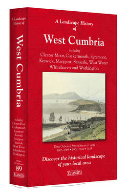
- West Cumbria 1864-1925 (3-map set)
- Map No. 89, West Cumbria 1864-1925 (3-map set), in the Cassini Historical Series of old Ordnance Survey mapping of England and Wales at 1:50,000 in a format designed to offer a convenient comparison with the present day coverage from the OS, and most locations in three different editions. Old historical maps have been combined so that the sheet... Read more