Ganaraska Hiking Trail
Description
- Name Ganaraska Hiking Trail (GHT)
- Length of trail 500 km, 311 miles
- Length in days 20 days
- Start of trail Port Hope
- End of trail Georgian Bay / Wasaga Beach
- Traildino grading MW, Moderate walk, backpacking trail
- Hut tour grading T1, Walk
 Port Hope – Georgian Bay / 400 km, Wasaga Beach / +100 km, 25 days
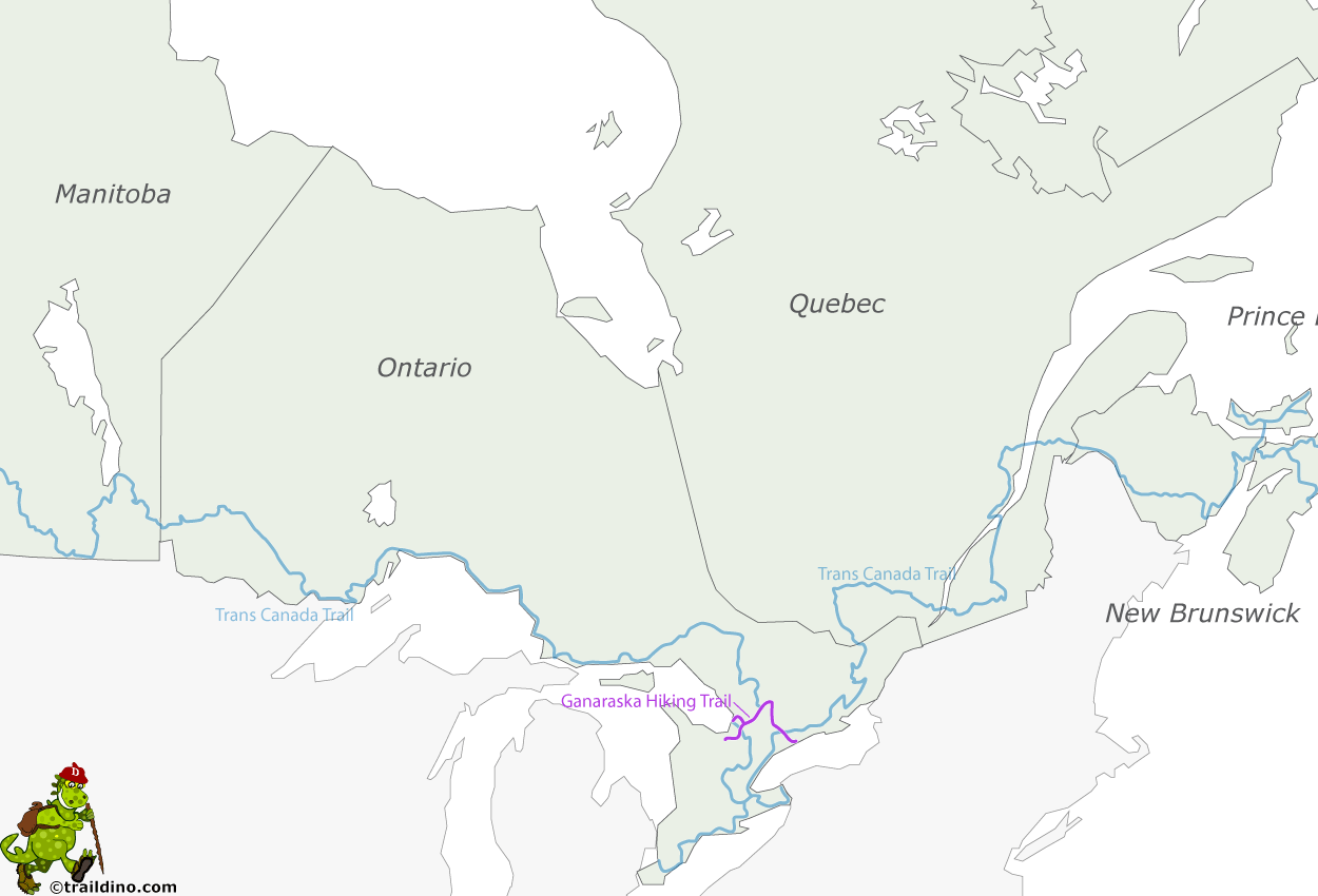
The Ganaraska Hiking Trail connects Port Hope on Lake Ontario with the Bruce Trail, 400 km in total. The trail is named after the Ganaraska Forest. From Lake Ontario, the trail heads north and west towards Lake Huron via Lake Simcoe.
Start and end of the trail pass through a gently sloping land of fields, woods and lakes. Use is made of quite a few beaver dams that were not intended for the hiker of course, but how else to arrive at the opposite side? The route uses small roads and paths. There are complaints about ATVs ruining the trail.
The middle part of the Ganaraska Hiking Trail is a wilderness trail in the rugged Canadian Shield. This part is harder to walk and your gear must be in accordance to the difficult terrain.
The trail ends on the shores of Georgian Bay, the edge of the Niagara Escarpment, where it meets the Bruce Trail. There is a 100-km long side stretch to Wasaga Beach.
Map
Links
Facts
Reports
Guides and maps
Lodging
Organisations
Tour operators
GPS
Other
Books

United Kingdom
- The Great Himalaya Trail N3
- The Rara, Jumla & Mugu Section Read more

Netherlands
- The Sheep And Wool Industry Of Australasia; A Practical Handbook For Sheep Farmers And Wool-Classers, With Chapters On Wool-Buying And Selling, Sheep-Skins, And Kindred Products
- C O N T E N T S. THE SHEPHERD PAGE The shepherd left his flock, and then the steep ., . I THE SINGER The man could sing blown from a southern sea . . 5 THE GATES OF CHRYSOPRASE They halted at the gates of chrysoprase . . . . 7 THE WOODS OF ALDERNAIN Woods of Aldernain . . . . ., . . 12 A DREAMERSV ENICE This is Venice, this the centre of a... Read more
- Also available from:
- Bol.com, Belgium

Belgium
- The Sheep And Wool Industry Of Australasia; A Practical Handbook For Sheep Farmers And Wool-Classers, With Chapters On Wool-Buying And Selling, Sheep-Skins, And Kindred Products
- C O N T E N T S. THE SHEPHERD PAGE The shepherd left his flock, and then the steep ., . I THE SINGER The man could sing blown from a southern sea . . 5 THE GATES OF CHRYSOPRASE They halted at the gates of chrysoprase . . . . 7 THE WOODS OF ALDERNAIN Woods of Aldernain . . . . ., . . 12 A DREAMERSV ENICE This is Venice, this the centre of a... Read more
Maps

United Kingdom
- Monastry Circuit Trail
- The Monastery Trail south of Lukla at 1:100,000 in the Nepa Maps series which provides extensive coverage of trekking areas of Nepal on detailed contoured maps with trekking routes and hiking trails, huts and camp sites, local places of interest and other tourist information.The map covers an area from Namche Bazar southwards along the Dudh... Read more

United Kingdom
- Makalu Region Great Himalay Trail Map
- Makalu Region, map no. 102, at 1:100,000 on a waterproof and tear-resistant trekking map from the Himalayan MapHouse in their series covering the whole of northern Nepal. The map highlights main trekking routes from Tumlingtar northwards: the Makalu Base Camp Trek and the route to Kimathangka, a local route east of the town, plus the relevant... Read more

United Kingdom
- Mustang Great Himalaya Trail Map
- Mustang, map no. 108, at 1:100,000 on a waterproof and tear-resistant trekking map from the Himalayan MapHouse in their series covering the whole of northern Nepal. The map shows the region north of the upper section of the Annapurna Circuit, beyond Jomsom/Jomosom and Muktinath, and highlights the route to Garphu, the Mustang to Phu trek, the... Read more

United Kingdom
- Solu Khumbu - Everest Region Great Himayala Trail Map
- Solu Khumbu/Everest Region, map no. 103, at 1:100,000 on a waterproof and tear-resistant trekking map from the Himalayan MapHouse in their series covering the whole of northern Nepal. The map highlights main trekking routes from Lukla, both north and south of the town: Everest Base Camp Trek, alternative routes to the Gokyo Lakes, Bhote Koshi... Read more

United Kingdom
- Kanchenjunga Region Great Himalaya Trail Map
- Kanchenjunga Region, map no. 101, at 1:100,000 on a waterproof and tear-resistant trekking map from the Himalayan MapHouse in their series covering the whole of northern Nepal. The map highlights main trekking routes from Taplejung, including Kanchenjunga Base Camp Trek, Yalung Base Camp Trek, Phathibhara Trek, the route along the Yangma Khola... Read more

United Kingdom
- Rolwaling Region Great Himalaya Trail Map
- The Rolwaling, map no. 104, at 1:100,000 on a waterproof and tear-resistant trekking map from the Himalayan MapHouse in their series covering the whole of northern Nepal. The map highlights main trekking routes from Jiri, both north and south of the town, including the first sections of the Jiri/Everest and Jiri/Pikey Peak trails, the Numbur... Read more

United Kingdom
- Rolwaling Region Great Himalaya Trail Map SUPERCEDED
- The Rolwaling, map no. 104, at 1:100,000 on a waterproof and tear-resistant trekking map from the Himalayan MapHouse in their series covering the whole of northern Nepal. The map highlights main trekking routes from Jiri, both north and south of the town, including the first sections of the Jiri/Everest and Jiri/Pikey Peak trails, the Numbur... Read more

Netherlands
- Wandelkaart NP108 Mustang - Nepal | Himalayan Maphouse
- Mustang, map no. 108, at 1:100,000 on a waterproof and tear-resistant trekking map from the Himalayan MapHouse in their series covering the whole of northern Nepal. The map shows the region north of the upper section of the Annapurna Circuit, beyond Jomsom/Jomosom and Muktinath, and highlights the route to Garphu, the Mustang to Phu trek, the... Read more

Netherlands
- Wandelkaart The Great Himalaya Trail | GHT
- Prachtige kaartenserie van één van 'swerelds mooiste wandeltochten. The Far West is one of the least explored areas of Nepal. Its area is bounded to the east by mighty, turquoise Karnali river which flows from Tibet’s sacred Mount Kailash. Myth and superstition remain part of the fabric of life here. Though the Nepali language originated... Read more


