
Everest Trek
Description
- Name Everest Trek
- Length in days 9 days
- Start of trail Lukla
- End of trail Basecamp
- Traildino grading SW, Strenuous walk, mountain trail
- Hut tour grading T2, Mountain walk

From Jiri 16 days to Basecamp, from Lukla 9 days.
Nepal is home to the highest mountain in the world, which sits right on the border with Tibet. Mount Everest, associated with ever so many famous names and stories, is within easy reach of the ordinary hiker. Not the 8840 m high summit, of course. But at 3500 m lower down, at the foot of the mountain, is Everest Base-camp, achievable for any backpacker with a down-filled jacket and a strong constitution.
Giving this trail in Khumbu region extra cachet, is the feeling of walking in the footsteps of the renowned pioneers who mapped this area and finally conquered Everest. And it was no hit and run for these adventurers. The first climbers and their company of porters started out from Dharan, and later from Jiri. Even today, Jiri is a starting point of the Everest Basecamp Trek, although it is not the easiest place to start. The hike from Jiri to Lukla means climbing up and down a lot. Definitely excellent to test your fit-ness.
Many hikers these days choose to fly to Lukla, shortening the trek by a week. Lukla airport is not exactly spacious. If the weather is bad, there is no flight and you may have to wait for a day or more.
From Lukla it takes one day to walk to Namche Bazaar, and an-other seven days to reach the viewpoint summits of Kala Patar. From its low (5545 m) or the high (5623 m) summit you will enjoy spectacular views of Mount Everest, the nearby Nuptse, Lhotse, and the splendid double dome of Ama Dablam. Another day's hike will take you to Everest Basecamp at 5300 m, Khumbu Icefall and the towering massif behind (but Everest itself is out of sight).
Thanks to a huge choice of lodges all along the trail, this classic trek poses no difficulties for the strong and experienced hiker. Most risky are the altitude and the change of diet. Please keep in mind this trek is very popular, just like the Annapurna Circuit. October, but also April and September are busiest. During the monsoon (June, July, August) hikers are few, but views are limited. Winter months are quiet, but dreadfully cold. Spring is beautiful, but along with rising temperatures, humidity gradually builds up to culminate during monsoon.
Times are changing. Meanwhile the Chinese on the other side of the border have their own Everest Basecamp at the foot of the Everest. The good news: you can drive all the way up there in your 4WD, so no need to walk anymore.
Map


Links
Facts
Reports
Guides and maps
Lodging
Organisations
Tour operators
GPS
Other
Books
United Kingdom
- Trekking Everest Base Camp - The Day to Day Guide
- and what isn't in the guidebooks Read more


United Kingdom
- The Girl Who Climbed Everest: The inspirational story of Alyssa Azar, Australia's Youngest Adventurer
- The Inspirational Story of Alyssa Azar, Australia's Youngest Adventurer Read more

United Kingdom
- A Trekking Guide to Everest
- Everest Base Camp, Gokyo Lakes, Thame Valley, Three High Passes, Classic Everest, Arun Valley Read more

United Kingdom
- The Great Himalaya Trail N3
- The Rara, Jumla & Mugu Section Read more


United Kingdom
- Doofus Dad Does Everest Base Camp
- One of Planet Earth's epic adventures told by a slightly-less-than-epic guy Read more


United Kingdom
- Everest England
- A unique hill-walking guide with a culminative ascent of the height of Everest, written in Peter Owen Jones` unique descriptive style. Scaling the peaks of Everest, the world`s highest mountain, is the ultimate physical and mental challenge that the human race can aspire to. But as it takes years of preparation and a minimum of £25,000 to... Read more
- Also available from:
- The Book Depository, United Kingdom


United Kingdom
- Everest Base Camp and Beyond
- The Practical Guide to Boutique Travel in Nepal Read more
Maps

United Kingdom
- Everest Base Camp & Gokyo - Three Passes 50K
- Everest Base Camp - Gokyo - Three Passes Trek map at 1:50,000 from Nepa Maps prominently highlighting the Three Passes Trek from Lukla and Namche along a section of the Everest Trek via Tengboche and Dingboche to the Thokla Pass, then westwards to the Cho (Chhugyuma) La Pass, Gokyo Lake and the Rejno La Pass, and southwards back to Namche via... Read more

United Kingdom
- Everest Region Trekking Map
- Mount Everest area on a trekking map at 1:75,000 from the Kolkata/Calcutta based Milestone Books, highlighting main trekking routes and showing peaks, passes and selected locations with altitude both in metres and feet. Coverage extends from just south of Lukla to the Chinese side of Mount Everest and the peaks of Cho Oyo and Gyachung Kang.The... Read more

United Kingdom
- Numbur Cheese Circuit
- Numbur Cheese Circuit at 1:100,000 in the Nepa Maps series which provides extensive coverage of trekking areas of Nepal on detailed contoured maps with trekking routes and hiking trails, huts and camp sites, local places of interest and other tourist information.The map covers the same area as the publishers’ “Jiri to Everest” title and has... Read more

United Kingdom
- Island Peak (Imja Tse)
- The trek from Namche to the base camp of the Island Peak (Imja Tse) with the climbing route to the peak itself annotated with views towards the surrounding mountains, presented by Nepa Maps at 1:40,000. The map also includes plans of Namche and Lukla highlighting accommodation and other facilities.Namche is in the south-western corner of the... Read more

United Kingdom
- Island Peak / Imja Tse Nepa Maps Climbing Map
- The trek from Namche to the base camp of the Island Peak (Imja Tse) with the climbing route to the peak itself annotated with views towards the surrounding mountains, presented by Nepa Maps at 1:40,000. The map also includes plans of Namche and Lukla highlighting accommodation and other facilities.Namche is in the south-western corner of the... Read more

United Kingdom
- Tenzing-Hillary Trek - Jiri to Everest Base Camp
- One of Nepal’s most popular trekking routes, from Juri to the Base Camp of Mount Everest, presented on a double-sided map at 1:50,000 from Nepa Maps. Now named after the two conquerors of Everest, the main trek is prominently marked on the map, along with the route from Namche Bazaar to Gokyo Lakes. Also highlighted are numerous other treks in... Read more

United Kingdom
- Mt. Everest (Sagarmatha) - Hinku Himal
- Mount Everesr (Sagarmatha) - Hinku Himal, sheet no. 2786-04, in the topographic survey of Nepal at 1:50,000 published by the Nepali Government in the late 1990s and early 2000s and produced from remote sensing data by Finnish cartographers as part of that country’s international aid program. The maps cover 15’ x 15’ quadrangles.IMPORTANT –... Read more

United Kingdom
- Everest - Gokyo - Cho La - the Renjo Pass (60K)
- Everest – Gokyo - Cho La - Renjo Pass map at 1:60,000 from the Himalayan MapHouse, prominently highlighting the Three Passes Trek from Lukla and Namche along a section of the Everest Trek via Tengboche and Dingboche to the Thokla Pass, then westwards to the Cho (Chhugyuma) La Pass, Gokyo Lake and the Rejno La Pass, and southwards back to Namche... Read more

United Kingdom
- Ama Dablam
- Mt. Everest area on a contoured and GPS-compatible map at 1:40,000 from Nepa Maps, designed to show trekking routes from Namche, Tengboche and Pangboche towards the Ama Dablam and Imja Tse (Island Peak) Base Camps, and the continuation climbing routes towards these two peaks, Lhotse and Lhotse Star.With Thamo and Namche Bazar in the... Read more
United Kingdom
- Khumbu - Jiri to Everest Nepa Maps Trekking Map
- Trekking route from Juri to Lukla and Namche Bazaar, and then on to the Everest Base Camp presented on a map at 1:100,000 from Nepa Maps. In addition to the main trekking route from Jiri to Mt Everest the map also highlights several other routes in the Khumbu region including treks to Gokyo Lakes, Island Peak (Imja Tse), Mera Peak, Amphu Labsta... Read more

United Kingdom
- Solu Khumbu - Everest Region Great Himayala Trail Map
- Solu Khumbu/Everest Region, map no. 103, at 1:100,000 on a waterproof and tear-resistant trekking map from the Himalayan MapHouse in their series covering the whole of northern Nepal. The map highlights main trekking routes from Lukla, both north and south of the town: Everest Base Camp Trek, alternative routes to the Gokyo Lakes, Bhote Koshi... Read more

United Kingdom
2017
- Nepal Nelles
- Nepal on a waterproof and tear-resistant map from Nelles, presenting the whole country at 1:1,500,000, with its more visited central and eastern regions also shown in more detail at 1:480,000, plus enlargement of the Kathmandu Valley and the Rara Lake area and street plans of central Kathmandu City, Patan, Bhaktapur and the lakeside district of... Read more

United Kingdom
- Everest - Trekking Map & Complete Guide
- Everest Trekking Guide from Milestone Books with very detailed and informative stage-by-stage descriptions of main Mt Everest trek from Lukla and Namche Bazaar to the Everest Base Camp, plus the route to the Gokyo Lakes. Each route is presented on coloured map extracts from the accompanying separate fold-out map, includes a route profile, and... Read more
- Also available from:
- The Book Depository, United Kingdom

United Kingdom
- Everest: Trekking Map & Complete Guide
- Everest Trekking Guide from Milestone Books with very detailed and informative stage-by-stage descriptions of main Mt Everest trek from Lukla and Namche Bazaar to the Everest Base Camp, plus the route to the Gokyo Lakes. Each route is presented on coloured map extracts from the accompanying separate fold-out map, includes a route profile, and... Read more

United Kingdom
- Island Peak - Mera Peak
- Two peaks of Nepal’s western Himalayas, Island Peak (Imja Tse) and Mera Peak, presented by Swiss publishers Climbing Map on separate contoured and GPS compatible panels at 1:25,000; plus drawings showing approach routes to each peak, plans of Lukla and Namche Bazar, an overview map of the Khumbu Himal region, etc.On one side the main panel is... Read more
- Also available from:
- De Zwerver, Netherlands
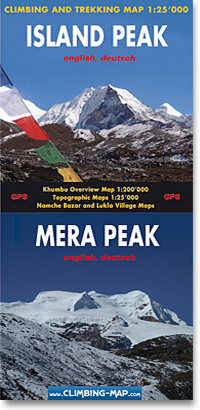
Netherlands
- Wandelkaart trekkingmap Island Peak - Mera Peak | Climbing-map
- Topographic climbing maps from Island & Mera Peak 1:25'000; village maps of Lukla and Namche Bazar, description of climbing routes, Khumbu general map 1:200'000; Panorama view, vegetation illustrations, climatic diagram, GPS information Read more

United Kingdom
- Khumbu Himal Schneider Nepal Map 02
- Khumbu Himal area at 1:50,000 on a waterproof and tear-resistant map in the famous Schneider series, revised in 2013 to include extensive tourist information for trekking routes to the Mount Everest Base Camp, Gokyo Lakes, Island Peak, Makalu Base Camp, etc. Coverage extends north from Namche Bazaar and along the Tibetan border from the Lunag... Read more
- Also available from:
- De Zwerver, Netherlands
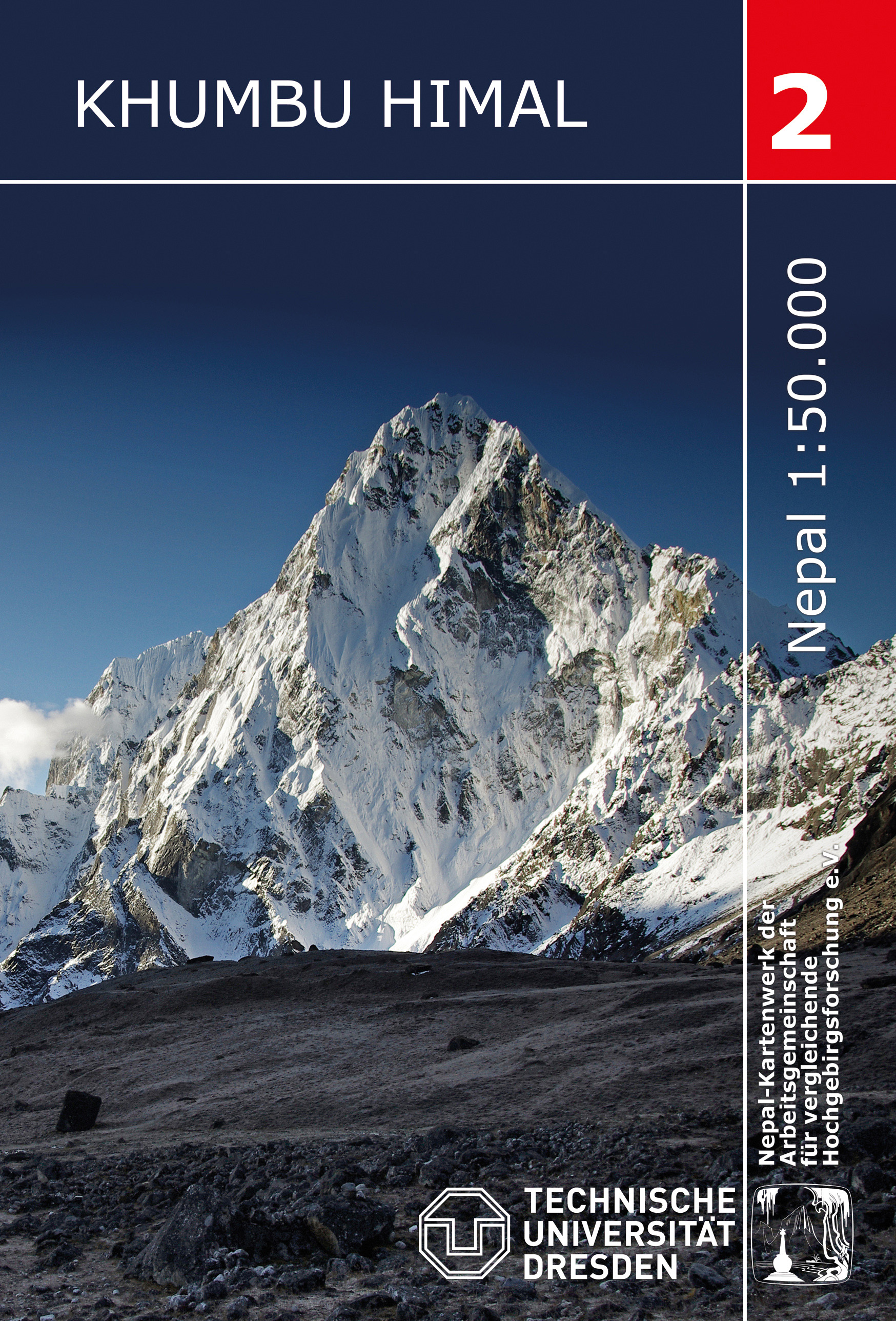
Netherlands
- Wandelkaart 02 Nepal Khumbu Himal | Nepal Kartenwerk
- Khumbu Himal area at 1:50,000 on a waterproof and tear-resistant map in the famous Schneider series, revised in 2013 to include extensive tourist information for trekking routes to the Mount Everest Base Camp, Gokyo Lakes, Island Peak, Makalu Base Camp, etc. Coverage extends north from Namche Bazaar and along the Tibetan border from the Lunag... Read more