
Great Eastern Trail
Description
- Name Great Eastern Trail (GET)
- Length of trail 2,575 km, 1,600 miles
- Length in days 170 days
- Traildino grading SW, Strenuous walk, mountain trail
- Hut tour grading T2, Mountain walk
 GET, 1600 miles (2575 km)
Hiking trail from Alabama to New York, in the eastern States, along the Appalachian Mountains. The proposed length is 1600 miles (2575 km) or even 2000 miles. The GET should get the pressure off the AT. Currently, many local organisations are working together to get a deffinite route proposal. Under construction.
Map


Links
Facts
Reports
Guides and maps
Lodging
Organisations
Tour operators
GPS
Other
Books

Stanfords
United Kingdom
United Kingdom
- The Brooklyn Nobody Knows: An Urban Walking Guide
- Bill Helmreich walked every block of New York City--6,000 miles in all--to write the award-winning `The New York Nobody Knows`. Now he has re-walked Brooklyn--some 816 miles--to write this one-of-a-kind walking guide to the city`s hottest borough. Drawing on hundreds of conversations he had with residents during his block-by-block journeys,... Read more

Stanfords
United Kingdom
United Kingdom
- Shadowplay - Longlisted for the 2020 Walter Scott Prize for Historical Ficiton
- Longlisted for the 2020 Walter Scott Prize for Historical FictionShortlisted for the Costa Novel Award 2019Winner of the Irish Book Awards Novel of the Year”Breathtaking... A hugely entertaining book about the grand scope of friendship and love” GuardianLondon, 1878. Fresh from life in Dublin, Bram Stoker – now manager of the Lyceum Theatre –... Read more

Stanfords
United Kingdom
2015
United Kingdom
2015
- Azores: Car Tours and Walks
- The Azores in the Sunflower Landscapes guide series; exploring the best walking and touring possibilities in the region or area. Detailed information about touring by hired car or public transport, as well as on foot, is provided, helping walkers to navigate and plan day-trips. Shorter strolls are also included as an alternative for each main... Read more

Stanfords
United Kingdom
United Kingdom
- Explorers: Amazing Tales of the World`s Greatest Adventures
- Meet famous explorers and adventurers in this exciting non-fiction storybook for children. Venture into steaming jungles in search of lost temples, fight off frostbite in the Arctic, and blast off into space!Great explorers have one thing in common - a desire to leap into the unknown, no matter how dangerous that might be. From Ferdinand... Read more

Stanfords
United Kingdom
United Kingdom
- DK Eyewitness Florida
- Welcome to the Sunshine StateWhether you want to visit the Mission Control Room at the Kennedy Space Center, take an airboat ride in the Everglades or discover the historic Coral Gables, your DK Eyewitness travel guide makes sure you experience all that Florida has to offer.Florida is known for its sun-kissed beaches and magical theme parks,... Read more

Stanfords
United Kingdom
2015
United Kingdom
2015
- Paxos: Car Tours and Walks
- Paxos is the Sunflower Landscapes guide to exploring the best walking and touring possibilities on the island. The guide covers a range of routes including walks in Gaios, Bogdanatika, Loggos, Lakka and Antixpaxos. A double-sided, fold-out touring map at the back of the book gives an overview of the island and the location of each walk.... Read more

Stanfords
United Kingdom
2019
United Kingdom
2019
- Insight Guides Great Breaks Devon & Cornwall (Travel Guide with Free eBook)
- Explore the best of Devon and Cornwall with this indispensably practical Insight Great Breaks Guide. From making sure you don`t miss out on must-see attractions like the Eden Project, Exeter, Tresco Gardens, Dartmoor and Torquay, to discovering hidden gems, including Tintagel, the easy-to-follow, ready-made walking routes will save you time,... Read more

Stanfords
United Kingdom
United Kingdom
- DK Eyewitness Greece: Athens and the Mainland
- Mainland Greece promises incredible ancient relics, inspiring cities, idyllic beaches, and mountains steeped in myth and legend.Whether you want to watch the sun sink behind the marble columns of the Parthenon in Athens, visit iconic archaeological sites such as Delphi and Olympia, or simply soak up the sun on the sandy beaches of Halkidiki,... Read more

Stanfords
United Kingdom
United Kingdom
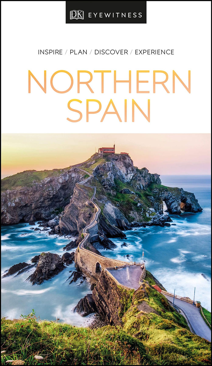
- DK Eyewitness Northern Spain
- Explore wild mountain terrain, vibrant cities and romantic coastline.Whether you want to trek the dramatic peaks of the Picos de Europa, appreciate contemporary art at Museo Guggenheim or hop from bar to bar in the side streets of San Sebastian, your DK Eyewitness travel guide makes sure you experience all that Northern Spain has to offer.Our... Read more

Stanfords
United Kingdom
United Kingdom
- Rick Steves Pocket Paris (Fourth Edition)
- Make the most of every day and every dollar with Rick Steves! This colorful, compact guidebook is perfect for spending a week or less in Paris: City walks and tours: Six detailed tours and walks showcase Paris`s essential sights, including the Louvre, the Orsay Museum, Notre-Dame, a stroll along the Left Bank, and moreRick`s strategic advice on... Read more
Stanfords
United Kingdom
United Kingdom
- DK Eyewitness Northern Spain
- Your journey starts here. Featuring DK`s much-loved maps and illustrations, walks and information, plus all new, full-colour photography, this 100% updated guide to Northern Spain brings you the best of this stunning Spanish region in a brand-new, lightweight format. What`s inside? - full-colour photography, hand-drawn illustrations, and maps... Read more

Stanfords
United Kingdom
United Kingdom
- Fuerteventura
- Fuerteventura in the Sunflower Landscapes guide series; exploring the best walking and touring possibilities in the region or area. Detailed information about touring by hired car or public transport, as well as on foot is provided, helping walkers to navigate and plan day-trips. Shorter strolls are also included as an alternative for each main... Read more
Stanfords
United Kingdom
United Kingdom
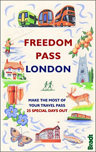
- Freedom Pass London
- Since its creation over 40 years ago, London`s Freedom Pass concessionary travel scheme has continued to grow in popularity and there are now over 1 million registered holders. Whether a fruit picker or forager, a rambler or angler, or simply someone who enjoys the quirky charm of a local pub, Bradt`s new Freedom Pass is the perfect read to... Read more

Stanfords
United Kingdom
United Kingdom
- DK Eyewitness Naples and the Amalfi Coast
- Discover a city that has stood the test of time.Whether you want to immerse yourself in the past at Pompeii and Herculaneum, relax with an alfresco drink by the turquoise waters of Capri or take a dip in Ischia`s thermal spas, your DK Eyewitness travel guide makes sure you experience all that Naples and the Amalfi Coast have to offer.One of the... Read more

Stanfords
United Kingdom
United Kingdom
- DK Eyewitness USA
- Spectacular scenery, vibrant cities and captivating culture - welcome to the USA.Whether you want to hike in breathtaking Yosemite National Park, take a road trip from coast to coast or sample southern soul food in the Deep South, your DK Eyewitness travel guide makes sure you experience all that the USA has to offer.Dramatic and diverse, the... Read more
Maps

Stanfords
United Kingdom
United Kingdom
- Dhunche (2885 14)
- Upper Langtang Valley, sheet no. 2885-15, in the topographic survey of Nepal at 1:50,000 published by the Nepali Government in the late 1990s and early 2000s and produced from remote sensing data by Finnish cartographers as part of that country’s international aid program. The maps cover 15’ x 15’ quadrangles.IMPORTANT – PLEASE NOTE BEFORE... Read more

Stanfords
United Kingdom
United Kingdom
- Barcelona High 5 Edition Street Plan
- The first water-resistant “Comfort Map“ with direct access to useful additional information from the InternetBarcelona in a scale of 1:20,000 including detailed presentation of the old town in a scale of 1:11,000 presented on a practical map; inclusive of the High 5 Edition app technology for calling up additional travel information and many... Read more

Stanfords
United Kingdom
United Kingdom
- Berlin High 5 Edition Street Plan
- The first water-resistant “Comfort Map“ with direct access to useful additional information from the InternetBerlin in a scale of 1:20,000 presented on a practical map; inclusive of the High 5 Edition app technology for calling up additional travel information and many other benefits:- just the right size - 9.6 x 16.1 cm - to fit comfortably... Read more

Stanfords
United Kingdom
United Kingdom
- Cycling the Canal de la Garonne: From Bordeaux to Toulouse
- This guidebook presents a cycle ride along the Canal de la Garonne in the south of France. The 290km route is covered in 7 stages from bustling Bordeaux to the splendid rose city of Toulouse, with a 135km excursion from to Lacanau on the Atlantic coast. Optional side trips explore the countryside and historical towns and villages, including... Read more
Stanfords
United Kingdom
United Kingdom
- Damodar Himal
- Damodar Himal, sheet no. 2884-01, in the topographic survey of Nepal at 1:50,000 published by the Nepali Government in the late 1990s and early 2000s and produced from remote sensing data by Finnish cartographers as part of that country’s international aid program. The maps cover 15’ x 15’ quadrangles.IMPORTANT – PLEASE NOTE BEFORE ORDERING:... Read more

Stanfords
United Kingdom
United Kingdom
- New York City High 5 Edition Street Plan
- The first water-resistant “Comfort Map“ with direct access to useful additional information from the InternetThe world-famous Manhattan district in a scale of 1:16,000 and an overview of New York City in a scale of 1:75,000 presented on a practical map; inclusive of the High 5 Edition app technology for calling up additional travel information... Read more
Stanfords
United Kingdom
United Kingdom
- Muktinath
- Koban, sheet no. 2883-07, in the topographic survey of Nepal at 1:50,000 published by the Nepali Government in the late 1990s and early 2000s and produced from remote sensing data by Finnish cartographers as part of that country’s international aid program. The maps cover 15’ x 15’ quadrangles.IMPORTANT – PLEASE NOTE BEFORE ORDERING:... Read more
Stanfords
United Kingdom
United Kingdom
- Nepal Survey 1:25,000 Sheet 2883 11B (Tatopani)
- Koban, sheet no. 2883-07, in the topographic survey of Nepal at 1:50,000 published by the Nepali Government in the late 1990s and early 2000s and produced from remote sensing data by Finnish cartographers as part of that country’s international aid program. The maps cover 15’ x 15’ quadrangles.IMPORTANT – PLEASE NOTE BEFORE ORDERING:... Read more
Stanfords
United Kingdom
United Kingdom
- Nepal Survey 1:25,000 Sheet 2883 11D (Patichaur)
- Koban, sheet no. 2883-07, in the topographic survey of Nepal at 1:50,000 published by the Nepali Government in the late 1990s and early 2000s and produced from remote sensing data by Finnish cartographers as part of that country’s international aid program. The maps cover 15’ x 15’ quadrangles.IMPORTANT – PLEASE NOTE BEFORE ORDERING:... Read more

Stanfords
United Kingdom
2018
United Kingdom
2018
- Ben Nevis & Glen Coe Harvey British Mountain Map XT40
- Waterproof mountain map of Ben Nevis & Glen Coe from Harvey at 1:40,000, with a geological map of the region on the reverse, an enlargement of Ben Nevis` summit, and advice on navigating the region safely.*MAIN MAP:* Topography is shown through clear altitude shading, spot heights, contours at 15m intervals, and index contours at 75m intervals.... Read more
- Also available from:
- The Book Depository, United Kingdom
- De Zwerver, Netherlands

The Book Depository
United Kingdom
2018
United Kingdom
2018
- Ben Nevis and Glen Coe
- Waterproof mountain map of Ben Nevis & Glen Coe from Harvey at 1:40,000, with a geological map of the region on the reverse, an enlargement of Ben Nevis' summit, and advice on navigating the region safely.MAIN MAP: Topography is shown through clear altitude shading, spot heights, contours at 15m intervals, and index contours at 75m intervals. A... Read more

De Zwerver
Netherlands
2018
Netherlands
2018
- Wandelkaart Ben Nevis & Glen Coe | Harvey Maps
- Waterproof mountain map of Ben Nevis & Glen Coe from Harvey at 1:40,000, with a geological map of the region on the reverse, an enlargement of Ben Nevis' summit, and advice on navigating the region safely.MAIN MAP: Topography is shown through clear altitude shading, spot heights, contours at 15m intervals, and index contours at 75m intervals. A... Read more

- Also available from:
- De Zwerver, Netherlands


Stanfords
United Kingdom
United Kingdom
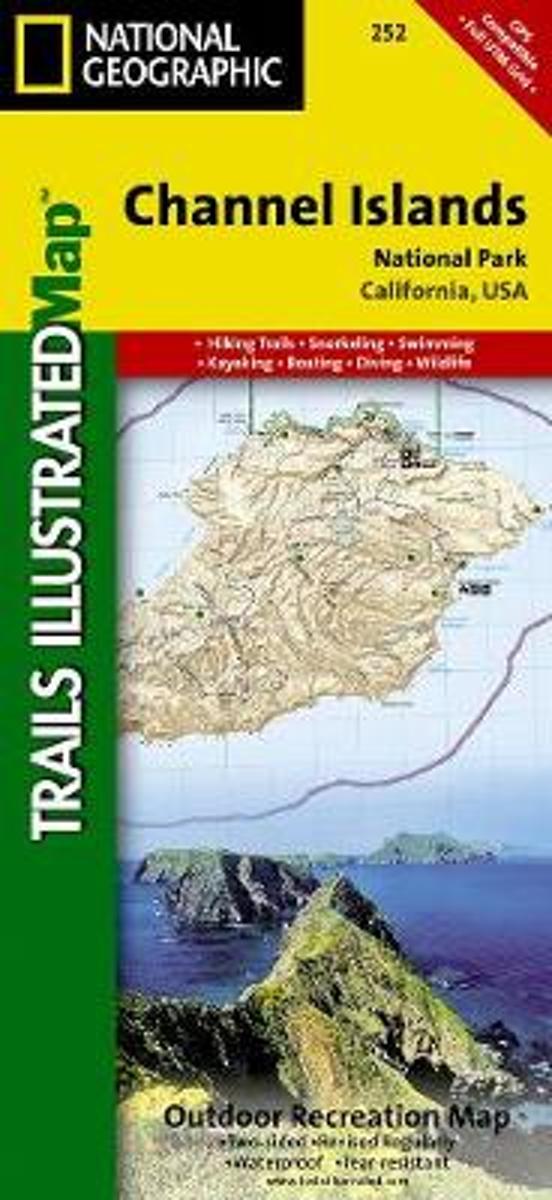
- Channel Islands National Park CA NGS Trails Illustrated Map 252
- Map No. 252, Channel Islands National Parkin California, at 1:25,000/1:50,000 in an extensive series of GPS compatible, contoured hiking maps of USA’s national and state parks or forests and other popular recreational areas. Cartography based on the national topographic survey, with additional tourist information.The maps, with most titles now... Read more
- Also available from:
- Bol.com, Netherlands
- Bol.com, Belgium
Bol.com
Netherlands
Netherlands
- Channel Islands National Park
- Waterproof Tear-Resistant Topographic MapThis two-sided map includes San Miguel Island, Santa Rosa Island, Santa Cruz Island, Santa Barbara Island, and Anacapa Island. The map combines beautiful cartography that shows the topology and natural features of each island, along with hiking trails, camping spots, rest areas, notable ship... Read more
Bol.com
Belgium
Belgium
- Channel Islands National Park
- Waterproof Tear-Resistant Topographic MapThis two-sided map includes San Miguel Island, Santa Rosa Island, Santa Cruz Island, Santa Barbara Island, and Anacapa Island. The map combines beautiful cartography that shows the topology and natural features of each island, along with hiking trails, camping spots, rest areas, notable ship... Read more

Ordnance Survey
United Kingdom
United Kingdom
- Ordnance Survey OS Wireless Heart Rate Monitor
- Measure and record your fitness with our wearable heart rate monitor. Whether you are a competitive athlete or need to consider your heart rate while working out for health reasons our wireless heart rate monitor can help you keep on track. Simple to pair with many compatible GPS devices you can get a recording when you want to track your... Read more

Stanfords
United Kingdom
United Kingdom
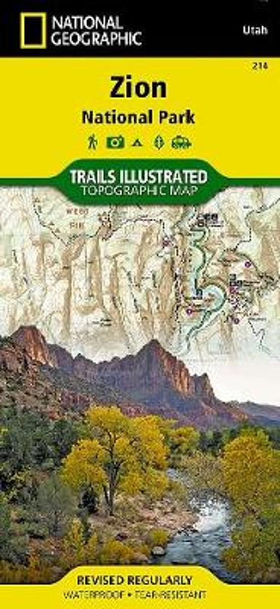
- Zion National Park UT NGS Trails Illustrated Map 214
- Map No. 214, Zion National Park, UT, in an extensive series of GPS compatible, contoured hiking maps of USA’s national and state parks or forests and other popular recreational areas. Cartography based on the national topographic survey, with additional tourist information.The maps, with most titles now printed on light, waterproof and... Read more
- Also available from:
- The Book Depository, United Kingdom
- Bol.com, Netherlands
- Bol.com, Belgium
- De Zwerver, Netherlands

Bol.com
Netherlands
Netherlands
- Zion National Park
- Waterproof Tear-Resistant Topographic MapExplore the beauty and geological wonder of Utah's first national park with National Geographic's Trails Illustrated map of Zion National Park. Created in partnership with local land management agencies, this expertly researched map combines unmatched detail with useful information to help you get... Read more
Bol.com
Belgium
Belgium
- Zion National Park
- Waterproof Tear-Resistant Topographic MapExplore the beauty and geological wonder of Utah's first national park with National Geographic's Trails Illustrated map of Zion National Park. Created in partnership with local land management agencies, this expertly researched map combines unmatched detail with useful information to help you get... Read more
.jpg)
De Zwerver
Netherlands
Netherlands
- Wandelkaart - Topografische kaart 214 Zion National Park | National Geographic
- Prachtige geplastificeerde kaart van het bekende nationaal park. Met alle recreatieve voorzieningen als campsites, maar ook met topografische details en wandelroutes ed. Door uitgekiend kleurgebruik zeer prettig in gebruik. Scheur en watervast! This National Geographic Trails Illustrated folded map offers comprehensive coverage of Zion National... Read more

Ordnance Survey
United Kingdom
United Kingdom
- ST&G's ST&G's Ludicrously Moreish Great British Food Map
- The Cheesiest map of Great Britain, brought to you by ST&G. Bursting full of over 2,000 food and drink locations, with a generous taste of trivia, this map will have you lusting after the variety of cuisine the Isles have to offer. Between Paddington's famous marmalade sandwiches to sandy seaside picnics, Britain has had a strange love affair... Read more
- Also available from:
- Ordnance Survey , United Kingdom

Ordnance Survey
United Kingdom
United Kingdom
- ST&G's ST&G's Ludicrously Moreish Great British Food Map
- The Cheesiest map of Great Britain, brought to you by ST&G. Bursting full of over 2,000 food and drink locations, with a generous taste of trivia, this map will have you lusting after the variety of cuisine the Isles have to offer. Between Paddington's famous marmalade sandwiches to sandy seaside picnics, Britain has had a strange love affair... Read more