Pyrenees
Description
The Pyrenees form the natural border between Spain and france. The mountain range extends from one sea to the other, from the Atlantic to the Mediterranean, always a good excuse for hikers to symbolically cross over and stay away from home two months.
Of course there is a fan group of the Pyrenees versus one of the Alps. The Pyrenees are very different from the Alps alltogether. There are no large lakes, but many high situated small ones. There are almost no passings over the Pyrenees from France into Spain. The famous exceptions - St Jean-Pied-de-Port and Col de Somport - are used by the Way of St. James, Camino de Santiago.
There are plenty of good hikes, among them the GR10, the Haute Randonnée Pyrénéenne, and - on the Spanish side, the GR11.
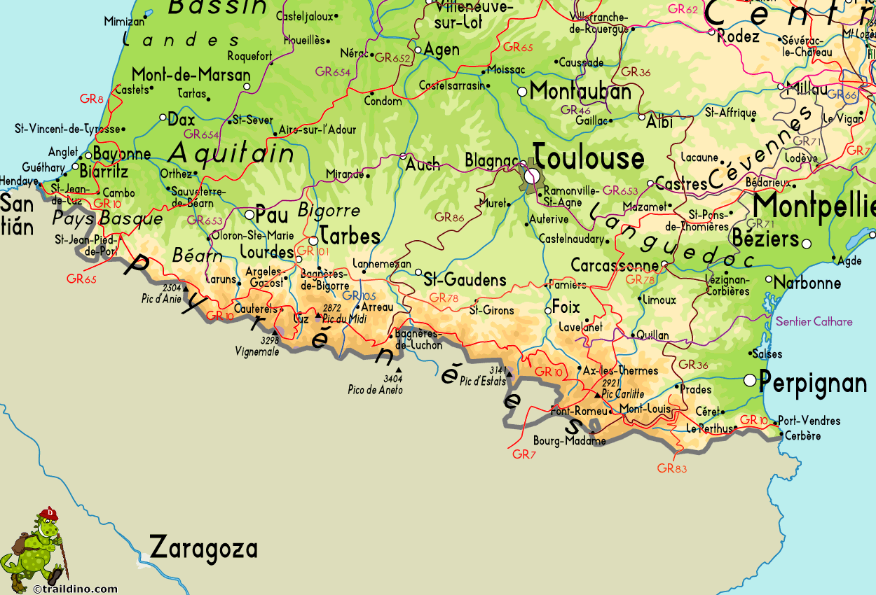
Map
Trails in this region
- Camino AragonésGPX
- Camino de BaztanGPX
- Camino de GironaGPX
- Camino FrancésGPX
- Carros de FocGPX
- E3GPX
- E4GPX
- E7GPX
- GR10 - Traversée des PyrénéesGPX
- GR101GPX
- GR107 - El Camí dels Bons HomesGPX
- GR11 Sendero PirenaicoGPX
- GR36 - Traversée du PérigordGPX
- GR65 - Via PodiensisGPX
- GR7GPX
- GR78 - Sentier de PiémontGPX
- GR8GPX
- GR83 - Camí del Nord o del CanigóGPX
- GR86GPX
- HRP - Haute Randonnée PyrénéenneGPX
- Sentier CathareGPX
- Tour du LarzacGPX
- Voie de Lourdes
- Voie du PiémontGPX
Links
Facts
Reports
Guides and maps
Lodging
Organisations
Tour operators
GPS
Other
Books

United Kingdom
2018
- Les Pyrénées Orientales à pied D066
- Les Pyrénées Orientales à pied, FFRP topo-guide Ref. No. D066, with 25 day walks of varying length and difficulty in the department of Pyrénées Orientales on the Mediterranean end of the mountain chain. Each walk is presented on a separate colour extract from IGN’s topographic survey of France at 1:25,000, with its description cross-referenced... Read more

United Kingdom
- Call of the Camino
- The experiences of an ordinary man on the pilgrim`s path are charted in this narrative that walks along the Camino Frances to the shrine of Saint James at Santiago de Compostela and then on to Finisterre, the westernmost point of Spain. The history of the Camino is recounted, as well as several of the myths, legends, and miracle stories that... Read more

United Kingdom
- GR3: Les Monts du Forez FFRP Topo-guide No. 334
- Les Monts du Forez, FFRP topoguide Ref. No. 334, covering in all 259kms along the GR3 and its variant, with additional descriptions of 21 day walks in the region. Current edition of this title was published in April 2016.ABOUT THE FFRP (Fédération française de la randonnée pédestre) TOPOGUIDES: published in a handy A5 paperback format, the... Read more

United Kingdom
- DK Eyewitness Spain
- Discover Spain - a compelling country filled with must-see sightsWhether you want to explore Granada`s spectacular Alhambra palace, watch swirling flamenco dancers in Seville or walk through lush countryside on the epic Camino de Santiago, your DK Eyewitness travel guide makes sure you experience all that Spain has to offer.From the golden... Read more

United Kingdom
- A Cyclist`s Guide to the Pyrenees
- Where do you turn when you want to ride in the mountains, to follow in the wheeltracks of professional racers by climbing the famous passes of the Tour de France? There are several books and websites that highlight these renowned ascents, detailing their location, length and every little change in gradient. But how do you go about finding a... Read more

United Kingdom
2019
- Les Hautes-Pyrénées à pied
- Les Hautes-Pyrénées à pied, FFRP topo-guide Ref. No. D065, with 45 day walks of varying length and difficulty in the heart of the French Pyrenees, from north of Tarbes to the Pyrenees National Park near Gavarnie. Current edition of this title was published in February 2016.To see the list of other FFRP guides with day walks please click on the... Read more

United Kingdom
2018
- Val d`Azun à pied ST10
- Val d`Azun à pied, FFRP topo-guide Ref. No. ST10, with 18 day walks of varying length and difficulty in the French Pyrenees south-west of Argelès-Gazost, plus a tour which includes part of the GR10 long-distance footpaths. Each walk is presented on a separate colour extract from IGN’s topographic survey of France at 1:25,000 and/or 1:50,000,... Read more

United Kingdom
- Taga - Serra Cavallera Editorial Alpina
- Taga – Serra Cavalara area in the eastern part of the Spanish Pyrenees on a contoured and GPS compatible map at 1:25,000 from Editorial Alpina, highlighting local and long-distance hiking trails, accommodation facilities, etc.The map has contour lines at 10m intervals enhanced by relief shading, plus colouring to indicate different types of... Read more

United Kingdom
2016
- Pyrenees: Car Tours and Walks
- Pyrenees is the Sunflower Landscapes guide to exploring the best walking and touring possibilities in the mountain range. The guide covers a range of routes including walks in Vilajuiga, Pedraforca, the Anisclo Canyon and Roncesvalles. A double-sided, fold-out touring map at the back of the book gives an overview of the region and the locations... Read more

United Kingdom
- St-Lary-Soulan et la Vallée d`Aure à pied ST07
- Saint-Lary-Soulan et la vallée d`Aure à pied, FFRP topo-guide Ref. No. ST07, with 25 day walks of varying length and difficulty in the French Pyrenees. Each walk is presented on a separate colour extract from IGN’s topographic survey of France at 1:25,000, with its description cross-referenced to the map. Current edition of this title was... Read more

United Kingdom
2021
- Camino de Santiago: The ancient Way of Saint James pilgrimage route from the French Pyrenees to Santiago de Compostela
- El Camino de Santiago de Compostela, the ancient Christian pilgrimage route has been travelled for over a thousand years to the Cathedral of Santiago de Compostela, where, legend has it, the bones of St James are buried. This guide follows the most popular route, starting at St Jean-Pied-de-Port in south-west France and heading all the way... Read more

United Kingdom
- Pyrénées, Toulouse and Gers Guide Vert Michelin - FRENCH Edition
- Pyrénées Toulouse Gers From the banks of the Canal du Midi to the Pyrenean peaks, from the bastides of Armagnac to the museums of Toulouse, set off to meet this generous and lively southwest, the land of festivals and gastronomy. Our authors in the field have selected:. 10 must-see pictures of the destination, 20 favorites, 8 itineraries of 3... Read more

United Kingdom
2020
- Les Abers - le Chemin de Phares GR34/GR34F
- Les Abers - le chemin de phares, FFRP topoguide Ref. no. 347, covering the coastal route in north-western Brittany between Morlaix, Brest, and le Fau, plus 4 walks on the Ile d`Ouessant. Current edition of this title was published in September 2017.Between Morlaix and Brest, where the sea has dug deep furrows in the land. More than 20 days of... Read more

United Kingdom
2020
- Tour du Larzac, Templier - Hospitalier - Entre causses et vallées GR71C/GR71D
- Tour du Larzac - Templier et Hospitalier, FFRP topoguide Ref. No. 710, covering the 195kms of hiking circuits along the GR71C and GR71D south of Millau in the Causse du Larzac, plus 13 local day walks. Current edition of this title was published in December 2015.ABOUT THE FFRP (Fédération française de la randonnée pédestre) TOPOGUIDES:... Read more

United Kingdom
- Les Monts du Beaujolais et du Lyonnais à pied FFRP Topo-guide No. P691
- Les Monts du Beaujolais et du Lyonnais à pied, FFRP topo-guide Ref. No. P691, with 34 day walks of varying length and difficulty in the region between Mâcon and St.Etienne, including a route along the GR7 and its variants. Each walk is presented on a separate colour extract from IGN’s topographic survey of France at 1:25,000, with its... Read more
Maps

United Kingdom
- Costabona - Alta Val de Ter Editorial Alpina
- Costabona - Alta Val de Ter area of the Catalan Pyrenees on a contoured and GPS compatible map at 1:25,000 from Editorial Alpina, highlighting hiking trails, campsites and refuges, etc. Topography is shown by contours at 10m intervals with relief shading and numerous spot heights, plus colouring for woodlands, brushwood, meadows and farmland.... Read more

United Kingdom
- Garrotxa - Zona Volcanica Editorial Alpina
- Garrotxa Volcanic Zone Natural Park near Olot in the Catalan Pyrenees on a contoured and GPS-compatible map at 1:25,000 from Editoral Alpina, highlighting local and long-distance hiking trails, etc, plus a booklet with 26 pages in English providing descriptions of 11 recommended local walks, etc.The map has contours at 10m intervals with relief... Read more

United Kingdom
2016
- Le Languedoc-Roussillon à pied FFRP Topo-guide No. RE13
- Le Languedoc-Roussillon à pied, FFRP topo-guide Ref. No. RE13, with 50 day walks in the some of the most visited departments in France: Lozère, Gard, Hérault, Aude and Pyrénées Orientales which include Mende, Alès, Nîmes, Montpellier, Béziers, Narbonne, Carcassonne and Perpignan. Each day walk is presented on a separate colour extract from... Read more

United Kingdom
- Bachimala - Valles de Chistau y Bielsa Editorial Alpina
- Bachimala area of the High Pyrenees in Spain on a contoured and GPS compatible map at 1:25,000 from Editorial Alpina, with a booklet including English language descriptions of recommended walks, extensive accommodation list, etc. With the peak of Gran Bachimala towards the north-eastern corner of the map, coverage extends west to Bielsa and... Read more

United Kingdom
- Alt Pirineu Natural Park Editorial Alpina
- Alt Pirineu Natural Park in the Catalan Pyrenees on a contoured and GPS compatible map at 1:50,000 from Editorial Alpina. Coverage extends northwards from La Seu d’Urgell and Sort beyond the French border to Aulus-les-Bains. Accompanying booklet includes an extensive list of contact details for various types of local accommodation.The map has... Read more

United Kingdom
- Ordesa - Monte Perdido National Park Editorial Alpina 2-Map Set
- Ordesa and Monte Perdido National Park at 1:25,000 in a set of two GPS compatible recreational maps in an extensive and very popular series from Editorial Alpina, providing more detailed coverage of this popular hiking area.Contours are at 10m intervals, with relief shading and vegetation colouring. An overprint highlights waymarked PR hiking... Read more

United Kingdom
- Vall de Barravés - Ribagorça Editorial Alpina
- Val de Barravés - Ribagorça at 1:25,000 in an extensive and very popular series of walking maps from Editorial Alpina covering the Pyrenees, Catalonia and other selected hiking areas in Spain, including Picos de Europa, Sierra Nevada and parts of Andalucía, Majorca, etc.Scales of maps in this series vary from 1:50,000 to 1:10,000, with the... Read more

United Kingdom
- Bourg-Madame - Pic Carlit - Col de Puymorens IGN WATERPROOF 2249OTR
- Topographic survey of France at 1:25,000 in IGN`s excellent TOP25 / Série Bleue series. All the maps are GPS compatible, with a 1km UTM grid plus latitude and longitude lines at 5’ intervals. Contours are at 5m intervals except for mountainous areas where the maps have contours at 10m intervals, vividly enhanced by hill shading and graphics for... Read more

United Kingdom
- Canary Islands Autonomous Region CNIG Physical Road Map
- Canary Islands Autonomous Region of Spain at 1:350,000 on a large physical map from the IGN/CNIG - country’s civilian survey organization providing an excellent picture of the region’s topography, from the peaks of the highest part of the Pyrenees, across the valley of the Ebro, to the sierras of southern Teruel province. Icons prominently... Read more

United Kingdom
- Grande Traversée Ariège-Pyrénées à VTT: Ax-les-Thermes – Lacave (223km)
- Grande Traversée Ariège-Pyrénées à VTT: Ax-les-Thermes - Lacave (223km) from Chamina covers a 223km mountain bike route in the central part of the French Pyrenees, shown on 1:50,000 topographic survey mapping from the IGN with additional tourist information.The title is presented as a boxed set of 15 loose pages plus a booklet with practical... Read more

United Kingdom
- Pyrenees East - Barcelona - Costa Brava 500K CNIG Regional Map No. 4
- The eastern part of Spanish Pyrenees, with coverage extending along the Mediterranean coast beyond Barcelona to Tarragona, at 1:500,000 in a series of regional road maps from the country’s civilian survey organization IGN-CNIG (Instituto Geográfico Nacional - Centro Nacional de Información Geográfica), vividly presenting the topography by... Read more

United Kingdom
2019
- Pyrénées Orientales et tours du Capcir, du Carlit et de Cerdagne GR10/GR36
- More than 30 days of hiking, including 12 to join Banyuls in Mérens-les-Vals.Pyrénées Orientales, FFRP topoguide, Ref. No. 1092, covering the fourth and last section of the GR10 along the Pyrenees from the Atlantic to the Mediterranean – a 196-km long walk from Mérens-les-Vals to Banyuls-sur-Mer. The guide also covers a 177-km trail along the... Read more

United Kingdom
- Oloron-Saint-Marie - Vallee d`Aspe IGN 1546OT
- Topographic survey of France at 1:25,000 in IGN`s excellent TOP25 / Série Bleue series. All the maps are GPS compatible, with a 1km UTM grid plus latitude and longitude lines at 5’ intervals. Contours are at 5m intervals except for mountainous areas where the maps have contours at 10m intervals, vividly enhanced by hill shading and graphics for... Read more

United Kingdom
- Tour of the Canigó Hiking Circuit
- A 64-km long tour of Canigó (Canigou), the highest mountain in the eastern Pyrenees, presented by Editorial Alpina on a contoured, GPS compatible map at 1:25,000, with a booklet providing descriptions of its recommended stages.The map has contours at 20m intervals, enhanced by relief shading. The tour which follows sections of the GR10, the HRP... Read more

United Kingdom
- Massif des Vosges - Plaine d`Alsace IGN Top200 201
- Pyrénées Ouest map from the IGN at 1:200,000, with excellent presentation of the terrain through contours and vivid relief shading, plenty of names of topographic features, long-distance GR hiking routes, places of interest, etc. The map is designed to provide convenient coverage of the western and central part of the Pyrenees, extending across... Read more


