
Alps
Description

The Alps, main mountain range of Europe, extending from France to Slovenia, including Austria, Italy, Germany, Switzerland, Liechtenstein. Highest summit is Mont Blanc (4.810), on the frontier of France, Switzerland and Italy, home of the popular Tour du Mont Blanc.
The Alps are, contrary to what most people think, not the largest mountain range in Europe. The Carpathians actually are more extensive, but not as high.
Often, hikers from outside Europe ask where to go in the Alps, which trail is best. Obviously, this is something every individual has to decide upon herself. The range of hiking opportunities in the Alps is huge. Beautiful country walks are within reach of snow capped mountains where someone else is sweating on a rope to get over a glacier. There are plenty of long distance trails combining different areas, although most people stick to one area. Some like to stay in a hotel and make day walks. Others fancy a hut-tour.
Let's be clear on another point: the facilities in the Alps are among the best in the world. Some would argue they are over the top. Thousands of huts – and very good ones too – lots of ski lifts, well marked trails.
Okay, we from Traildino do have some advice. First, take into account the local culture of an area. Many Alpine regions have a long and rich history which is there to enjoy. The different countries sharing the Alps are all very different, and the regional differences are equally astonishing. This is really a part of the fun here: enjoying nature, enjoying people and hospitality. Second tip: famous is not best. You will probably think of flying to the Matterhorn or Mont Blanc or something equally famous. Needless to say: these area's are very busy and by no means the most impressive or beautiful. Pretty as they are, also the different national parks draw many visitors and hikers are packed in large huts when aiming at the high peaks. If that's what you want: fine. If you prefer a small hut where a local warden makes you the best dinner you've ever had and where you can have a chat with the other three guests while inhaling the sounds and fumes of the end of the day, than virtually every region in the Alps has its charms.
Map

Trails in this region
- AdlerwegGPX
- Aletsch PanoramawegGPX
- AlpannoniaGPX
- Alpen Weitwanderweg
- Alpenkranz Uri
- Alpenpanorama-WegGPX
- AlpenpässewegGPX
- Alta Via dei GigantiGPX
- Alta Via dei Monti LiguriGPX
- Alta Via Della Valle d'Aosta No 1
- Alta Via Della Valle d'Aosta No 2
- Alta Via Dolomiti 1GPX
- Alta Via Dolomiti 10
- Alta Via Dolomiti 2GPX
- Alta Via Dolomiti 3GPX
- Alta Via Dolomiti 4GPX
- Alta Via Dolomiti 5
- Alta Via Dolomiti 6GPX
- Alta Via Dolomiti 7
- Alta Via Dolomiti 8
- Alta Via Dolomiti 9
- ArnowegGPX
- Ämtlerweg
- Bassa Via del GardaGPX
- Berliner HöhenwegGPX
- Berner Voralpenweg
- Chemin des BissesGPX
- Chemin du VignobleGPX
- Dachstein-Tauern Panoramaweg
- E10GPX
- E2GPX
- E4GPX
- E5GPX
- E6GPX
- Eisenwurzenweg - 8GPX
- EmmenuferwegGPX
- Freiburger VoralpenwegGPX
- Furka HöhenwegGPX
- Gailtaler HöhenwegGPX
- GoethewegGPX
- GR5GPX
- GR50 - Tour des ÉcrinsGPX
- GR510 - Sentier des huit valléesGPX
- GR54 - Tour de l'Oisans et des ÉcrinsGPX
- GR541
- GR549
- GR55 - Tour de la VanoiseGPX
- GR56 - Tour de l'UbayeGPX
- GR58 - Tour du QueyrasGPX
- GR65 - Via PodiensisGPX
- GR653 - Via TolosanaGPX
- GR653D - Voie d’ArlesGPX
- GR9GPX
- GR91 - Traversée du VercorsGPX
- GR93GPX
- GR94 - Tour des Hautes-AlpesGPX
- GR946
- GR95GPX
- GR96 - Traversée des BaugesGPX
- Grande Traversata del Gran Paradiso
- Grande Traversata delle AlpiGPX
- Grenzpfad NapfberglandGPX
- GTPA - Grande Traversée des PréalpesGPX
- Haute Route Chamonix-ZermattGPX
- Heidiland Wandertour
- Heilbronner HöhenwegGPX
- Hintere Gasse
- KalkalpenwegGPX
- Karnischer HöhenwegGPX
- Karwendel Höhenweg
- Kesch Trek
- Kreuzecker Höhenweg
- Lasörling HöhenwegGPX
- Lötschberg PanoramawegGPX
- Lechtaler HöhenwegGPX
- Liechtensteiner PanoramawegGPX
- Mariazeller Wege - 6GPX
- MaximilianswegGPX
- Meraner HöhenwegGPX
- Mittelbünden PanoramawegGPX
- Nationalpark PanoramawegGPX
- Nord-Süd Wanderweg - 5GPX
- Nordalpenweg - 1GPX
- Obwaldner HöhenwegGPX
- Pragelpass-WegGPX
- Prättigauer HöhenwegGPX
- Rätikon Höhenweg
- Rheintaler HöhenwegGPX
- Route du Temps
- Rupertiweg - 10GPX
- Salzburger AlmenwegGPX
- Salzsteigweg - 9GPX
- Sanetsch Muveran WegGPX
- Südalpenweg - 3GPX
- Schanfigger HöhenwegGPX
- Schladminger Tauern Höhenweg
- Schwyzer HöhenwegGPX
- SeealpentourGPX
- Senda SegantiniGPX
- Senda SursilvanaGPX
- Sentiero CristallinaGPX
- Sentiero della PaceGPX
- Sentiero Lago di LuganoGPX
- Sentiero VerzascaGPX
- Slovene Geological Path
- Slovenska Planinska PotGPX
- Slovenska Planinska Pot (extended)
- Stubaier HöhenwegGPX
- Sub-Alpine Trail
- Tauernhöhenweg
- Thurgauer PanoramawegGPX
- ThurwegGPX
- Tiroler Höhenweg
- TMB - Tour du Mont BlancGPX
- Tour des CombinsGPX
- Tour des Dents du MidiGPX
- Tour des Grands Barrages
- Tour du Augstbordhorn
- Tour du BeaufortainGPX
- Tour du MatterhornGPX
- Tour du Saint-BernardGPX
- Tour du Val de BagnesGPX
- Tour du WildhornGPX
- Tour Monte RosaGPX
- Tour Val d'HérensGPX
- Trans-Swiss TrailGPX
- Traumpfad München-VenedigGPX
- Venediger HöhenwegGPX
- Verwall Höhenweg
- Via AlpinaGPX
- Via EngiadinaGPX
- Via FrancigenaGPX
- Via GebennensisGPX
- Via JacobiGPX
- Via RhenanaGPX
- Via SbrinzGPX
- Via SplugaGPX
- Via StockalperGPX
- Via ValtellinaGPX
- Voralpenweg - 4GPX
- Walk of Peace
- Walliser SonnenwegGPX
- WALSA-wegGPX
- Weg der SchweizGPX
- Züri Oberland HöhenwegGPX
- Zürich-Zugerland PanoramawegGPX
- Zentralalpenweg - 2GPX


Links
Facts
Reports
Guides and maps
Lodging
Organisations
Tour operators
GPS
Other
Books

United Kingdom
2019
- Haute-Savoie a Pied - 54 circuits dont 8 adaptés à la marche nordique
- But don`t be fooled: if Haute-Savoie is home to the Mecca of mountaineering, it is also a hiker`s paradise! Beyond the GR® trails (the prestigious GR® 5 and GR® Tour du Mont Blanc), discover the diversity of the landscapes of a department with dynamic demography and economy. Pure lake waters, freshness of deep forests, distant horizons of... Read more

United Kingdom
2017
- Chemins de St. Jacques: Toulouse - Jaca - Lourdes GR653/GR101/GR78
- The last stretch of the Toulouse route before reaching Spain and the Camino Frances.Chemins de St. Jacques: Toulouse - Jaca, FFRP topoguide Ref. No. 6534, covering one of the southern routes of the Way of St. James in France: from Toulouse along the GR 653, with variants through Pau or Tarbes, across Col du Somport to Jaca in the Spanish... Read more
United Kingdom
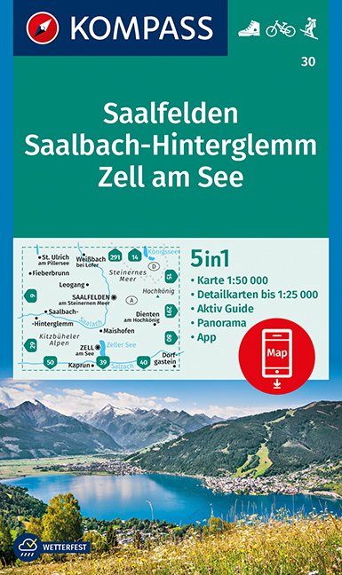
- Saalfelden - Saalbach-Hinterglemm - Zell am See Kompass 30
- Saalfelden - Saalbach - Zell am See (No. 30), a detailed, GPS compatible map at 1:50,000 from Kompass with local and long-distance footpaths, cycling routes, accommodation, etc, printed on durable, waterproof and tear-resistant synthetic paper. This title has on the reverse an additional panorama map of the region.KOMPASS HIKING & RECREATIONAL... Read more

United Kingdom
2018
- Sentiers de St-Jacques via le Puy - Le Puy to Figeac GR65
- Chemins de St-Jacques: Le Puy - Figeac, FFRP topoguide Ref. no. 651, covering a 252km section of the Way of St. James across the Massif Central from Le Puy-en-Velay to Figeac along the GR 65. Current edition of this title was published in August 2014.ABOUT THE FFRP (Fédération française de la randonnée pédestre) TOPOGUIDES: published in a handy... Read more

United Kingdom
- Wolfgangsee - Fuschlsee - Mondsee Kompass 018
- Wolfgangsee - Fuschlsee - Mondsee, the lakes of the Salzkammergut area east of Salzburg, on a detailed, GPS compatible map at 1:25,000 from Kompass with local and long-distance footpaths, cycling routes, accommodation, etc, printed on durable, waterproof and tear-resistant synthetic paper.KOMPASS HIKING & RECREATIONAL MAPS: this title is part... Read more

United Kingdom
- Landeck - Nauders - Samnaungruppe Kompass 42
- Landeck - Nauders - Samnaungruppe (No. 42), a detailed, GPS compatible map at 1:50,000 from Kompass with local and long-distance footpaths, cycling routes, accommodation, etc, printed on durable, waterproof and tear-resistant synthetic paper. KOMPASS HIKING & RECREATIONAL MAPS:This title is part of an extensive series covering Austria, much of... Read more

United Kingdom
- Schladming - Ramsau am Dachstein - Haus im Ennstal - Filzmoos - Stoderzinken F&B WK5201
- Schadming - Ramsau am Dachstein - Haus im Ennstal - Filzmoos - Stoderzinken area of the Austrian Alps presented at 1:35,000 in a series of contoured and GPS compatible outdoor leisure map from Freytag & Berndt with hiking and cycling routes, mountain huts, campsites and youth hostels, local bus stops, plus other tourist information. Cartography... Read more

United Kingdom
- Chemins de St.Jacques: Cluny/Lyon - Le Puy à pied
- Chemins de St.Jacques: Cluny/Lyon-Le Puy à pied from Chamina presents the route overprinted on IGN’s 1:50,000 topographic survey with details of accommodation, local services and other tourist information.Each stage is shown on extracts from IGN`s 1:50,000 topographic survey cross-referenced to the descriptions of the route. Symbols indicate... Read more

United Kingdom
- Münsterland 3-Map Set Kompass 849
- The Münsterland region of North Rhine-Westphalia on a set of three detailed, GPS compatible maps at 1:50,000 from Kompass with local and long-distance footpaths, cycling routes, accommodation, etc. Coverage extends north to Osnabrück and Enschede in the Netherlands, and south to Hamm and Reckinghausen.KOMPASS HIKING & RECREATIONAL MAPS:This... Read more
United Kingdom
2017
- Le PNR du Haute-Jura à pied PN15
- Le Parc du Haute-Jura à pied, FFRP topo-guide Ref. No. PN15, with 41 day walks of varying length and difficulty in the French Jura, plus several two- to seven-days long tours including a section of GR9. Each day walk is presented on a separate colour extract from IGN’s topographic survey of France at 1:25,000, with its description... Read more

United Kingdom
- Millstätter See - Nockgebiet Kompass 63
- Millstätter See - Nockgebiet (No. 63), a detailed, GPS compatible map at 1:50,000 from Kompass with local and long-distance footpaths, cycling routes, accommodation, etc, printed on durable, waterproof and tear-resistant synthetic paper. This title has on the reverse an additional panorama map of the region.KOMPASS HIKING & RECREATIONAL... Read more

United Kingdom
- Ipswich, The Naze & Clacton-on-Sea OS Landranger Active Map 169 (waterproof)
- Ipswich with Harwich and The Naze area, including part of the E2 European Long-distance Path, on a waterproof and tear-resistant OS Active version of map No. 169 from the Ordnance Survey’s Landranger series at 1:50,000, with contoured and GPS compatible topographic mapping plus tourist information.MOBILE DOWNLOADS: As well as the physical... Read more
United Kingdom
2020
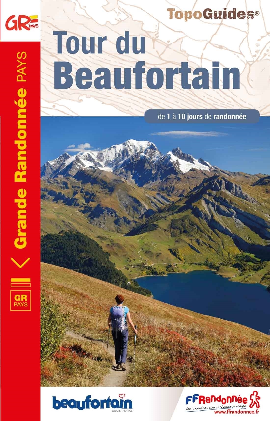
- Tour de Beaufortain
- GRP: Tour de Beaufortain, FFRP topo-guide ref. no. 731, one of the titles from an extensive series of light, high quality, A5 paperback guides to the Sentiers de Grande Randonnée, the GR routes, a dense network of long-distance footpaths across the French countryside. Each topo-guide covers either a circular route, or part of a longer path.... Read more

United Kingdom
- North York Moors Western OS Explorer Active Map OL26 (waterproof)
- The western part of the North York Moors National Park on a detailed topographic and GPS compatible map OL26, waterproof version, from the Ordnance Survey’s 1:25,000 Explorer series. Coverage extends from Ampleforth in the south northwards to Saltburn-by-the-Sea, and from Ingleby Arncliffe to Danby, Castleton and Hutton-le-Hole, and includes... Read more

United Kingdom
2014
- Les Hautes Alpes à pied FFRP Topo-guide No. D005
- Les Hautes Alpes à pied, FFRP topo-guide Ref. No. D005, with 41 day walks of varying length and difficulty in the French Alps, including in the Ecrins Massif, Queyras, Briançonnais and in the environs of Gap. Each walk is presented on a separate colour extract from IGN’s topographic survey of France at 1:25,000 or 1:50,000, with its description... Read more
Maps

United Kingdom
- Grosses Walsertal - Feldkirch - Bludenz - Laterns - Liechtenstein F&B WK375
- Grosses Walsertal - Feldkirch - Bludenz - Laterns - Liechtenstein area of the Austrian Alps presented at 1:50,000 in a series of contoured and GPS compatible outdoor leisure map from Freytag & Berndt with hiking and cycling routes, mountain huts, campsites and youth hostels, local bus stops, plus other tourist information. Coverage inclused the... Read more

United Kingdom
- Steinernes Meer Alpenverein KOMBI Map 10/1
- Steinernes Meer area of the Alps in a combined hiking and ski edition at 1:25,000 from a series of detailed, GPS compatible maps published by the DAV - Deutscher Alpenverein and produced by the German and Austrian Alpine Clubs using cartography from their respective survey organizations. Maps in this series have topography vividly presented by... Read more

United Kingdom
- Märkischer Kreis - Ebbegebirge
- Märkischer Kreis - Ebbegebirge (No. 749), a detailed, GPS compatible map at 1:50,000 from Kompass with local and long-distance footpaths, cycling routes, accommodation, etc, printed on durable, waterproof and tear-resistant synthetic paper.KOMPASS HIKING & RECREATIONAL MAPS:This title is part of an extensive series covering Austria, much of... Read more

United Kingdom
- Fichtelgebirge - Bayreuth - Marktredwitz Kompass 191
- Fichtelgebirge - Bayreuth - Marktredwitz (No. 191), a detailed, GPS compatible map at 1:50,000 from Kompass with local and long-distance footpaths, cycling routes, accommodation, etc, printed on durable, waterproof and tear-resistant synthetic paper. KOMPASS HIKING & RECREATIONAL MAPS:This title is part of an extensive series covering Austria,... Read more

United Kingdom
- Karwendelgebirge North - Schafreiter Alpenverein BY12
- Karwendelgebirge North - Schafreiter, map No. BY 12, in a series of highly detailed, GPS compatible hiking maps at 1:25,000 of the German Alps, published by the Deutscher Alpenverein, the German Alpine Club, with cartography of the German topographic survey from the Bavarian state survey organization. The maps use the survey’s excellent... Read more

United Kingdom
- Vorderes Zillertal - Achensee - Alpbachtal - Wildschonau Kompass 28
- Vorderes Zillertal - Alpbach - Rofan - Wildschönau (No. 28), a detailed, GPS compatible map at 1:50,000 from Kompass with local and long-distance footpaths, cycling routes, accommodation, etc, printed on durable, waterproof and tear-resistant synthetic paper. This title has on the reverse an additional panorama map of the region. KOMPASS HIKING... Read more

United Kingdom
- La Plagne Freeride Map
- The best rides in the freeride hot spots of the Alps – this is the simple formula of the Freeride Maps. The first map available to freeriders is making the locals freeride knowledge available to a broad public.All ridable slopes, drops and couloirs are marked as freeride corridors in different colours for three difficulty ratings: blue for... Read more

United Kingdom
- Val d`Arbia, Ombrone and Orcia
- The valleys of Arbia, Ombrone and Orcia in Tuscany directly south of Siena on a detailed contoured map at 1:50,000 from Litografia Artistica Cartografica highlighting the course of La Via Francigena and other waymarked local trails.The map covers an area from Siena southwards to Castel del Piano including several nature reserves. Topography is... Read more

United Kingdom
- Luneburg Heath Kompass 718
- Lüneburger Heide area of northern Germany on a detailed, GPS compatible map at 1:50,000 from Kompass with local and long-distance footpaths, cycling routes, accommodation, etc, printed on durable, waterproof and tear-resistant synthetic paper.KOMPASS HIKING & RECREATIONAL MAPS: this title is part of an extensive series covering Austria, much of... Read more

United Kingdom
- Serres - Veynes - Haut Buech - Bochaine IGN 3338OT
- Topographic survey of France at 1:25,000 in IGN`s excellent TOP25 / Série Bleue series. All the maps are GPS compatible, with a 1km UTM grid plus latitude and longitude lines at 5’ intervals. Contours are at 5m intervals except for mountainous areas where the maps have contours at 10m intervals, vividly enhanced by hill shading and graphics for... Read more

United Kingdom
- Chiemsee - Chiemgau Alps - Traunstein K+F Outdour Map 7
- Chiemsee Lake area of the German Alps at 1:35,000 from Kümmerly+Frey in a series GPS compatible, double-sided maps printed on durable, waterproof and tear-resistant plastic paper; contoured, with hiking and cycle routes, other recreational activities, etc. Maps in this series are at a scale of either 1:50,000 or 1:35,000. Contour interval... Read more

United Kingdom
- Julian Alps West Kartografija Tourist Map
- The western part of Slovenia’s Julian Alps on a contoured and GPS compatible map at 1:75,000 from the Ljubljana-based Kartografija. Coverage includes the Triglav National Park, Kranjska Gora, Bovec, Bled, Jesenice, Tolmin, Škofja Loka, etc. On the reverse are bilingual English/Slovenian descriptions of the region’s best sights.Maps in this... Read more

United Kingdom
- Ennstal Alps - Gesause Alpenverein KOMBI Map 16
- Ennstaler Alpen - Gesause area of the Alps in a combined hiking and ski edition at 1:25,000 from a series of detailed, GPS compatible maps published by the DAV - Deutscher Alpenverein and produced by the German and Austrian Alpine Clubs using cartography from their respective survey organizations. Maps in this series have topography vividly... Read more

United Kingdom
- Montafon Freeride Map
- The best rides in the freeride hot spots of the Alps – this is the simple formula of the Freeride Maps. The first map available to freeriders is making the locals freeride knowledge available to a broad public.All ridable slopes, drops and couloirs are marked as freeride corridors in different colours for three difficulty ratings: blue for... Read more
United Kingdom
- Nuremberg Land - Hersbrucker Alb Komapss 172
- Hersbrucker Land in der Frankenalb area of northern Bavaria, just east of Nuremburg, on a detailed, GPS compatible map at 1:50,000 from Kompass with local and long-distance footpaths, cycling routes, accommodation, etc, printed on durable, waterproof and tear-resistant synthetic paper.KOMPASS HIKING & RECREATIONAL MAPS: this title is part of an... Read more