
Galicia
Description
Autonomous region in the northwest of Spain.
Trails in this state
Links
Facts
Reports
Guides and maps
Lodging
Organisations
Tour operators
GPS
Other
Books

Stanfords
United Kingdom
United Kingdom
- Islands of the Galician Coast National Park CNIG Map-Guide SPANISH
- Islands of the Galician Coast National Park (PN Marítimo-Terrestre de las Islas Atlánticas de Galicia) at 1:25,000 on a contoured and GPS compatible map from IGN/CNIG with cartography from their topographic survey of Spain. The four groups of islands which form this national park are presented as a separate panel: Illa de Cortagada with the... Read more

The Book Depository
United Kingdom
2019
United Kingdom
2019
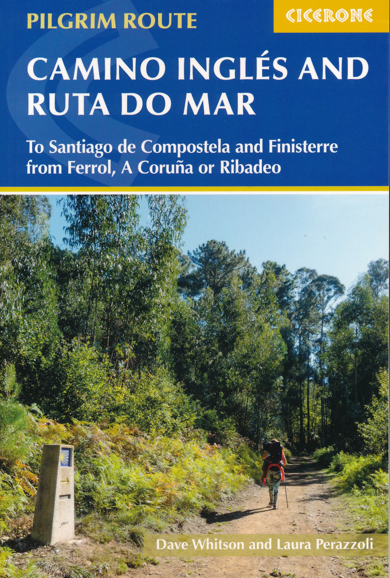
- The Camino Ingles and Ruta do Mar
- To Santiago de Compostela and Finisterre from Ferrol, A Coruna or Ribadeo Read more
- Also available from:
- De Zwerver, Netherlands
De Zwerver
Netherlands
2019
Netherlands
2019
- Wandelgids Camino Inglés and Ruta Do Mar | Cicerone
- Guidebook to walking the Camino Inglés and Ruta do Mar pilgrim routes in northwest Spain. Describes the 116km Camino Inglés from Ferrol or A Coruña to Santiago de Compostela and the of the 190km Ruta do Mar linking Ribadeo with the Inglés at Ferrol. Includes the 120km Camino Finisterre from Santiago to Finisterre or Muxia. Read more

The Book Depository
United Kingdom
2018
United Kingdom
2018
- The Camino Portugues
- From Lisbon and Porto to Santiago - Central, Coastal and Spiritual Caminos Read more

The Book Depository
United Kingdom
2022
United Kingdom
2022
- Lonely Planet Best Day Walks Spain
- Lonely Planet`s Best Day Walks Spain is your passport to 60 easy escapes into nature. Stretch your legs away from the city by picking a walk that works for you, from just a couple of hours to a full day, from easy to hard. Marvel at the Pyrenees, hike along the Mediterranean coast, and experience island walks in Mallorca. Inside Lonely... Read more
- Also available from:
- De Zwerver, Netherlands

De Zwerver
Netherlands
2022
Netherlands
2022
- Wandelgids Best Day Walks Spain - Spanje | Lonely Planet
- Lonely Planet`s Best Day Walks Spain is your passport to 60 easy escapes into nature. Stretch your legs away from the city by picking a walk that works for you, from just a couple of hours to a full day, from easy to hard. Marvel at the Pyrenees, hike along the Mediterranean coast, and experience island walks in Mallorca. Inside Lonely... Read more

The Book Depository
United Kingdom
2019
United Kingdom
2019
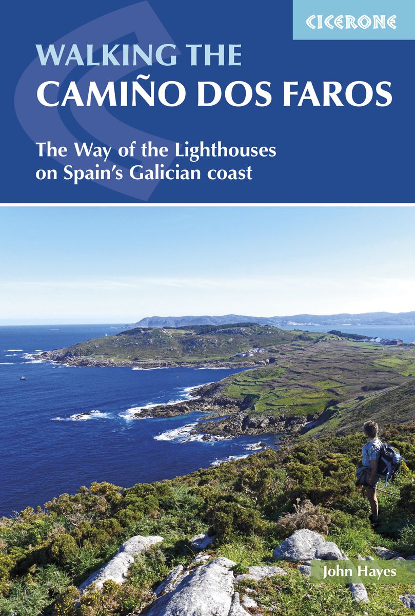
- Walking the Camino dos Faros
- The Way of the Lighthouses on Spain's Galician coast Read more
- Also available from:
- De Zwerver, Netherlands
De Zwerver
Netherlands
2019
Netherlands
2019
- Wandelgids Camino dos Faros | Cicerone
- Guidebook to walking the Camino dos Faros, the way of the lighthouses, along the Galician coast in northwest Spain. The 200km route is described across 8 stages of between 17 and 29km and takes in some of the area's most wild and enchanting coastal scenery, with dramatic cliffs and deep river estuaries. Incorporates some challenging walking. Read more


The Book Depository
United Kingdom
2020
United Kingdom
2020
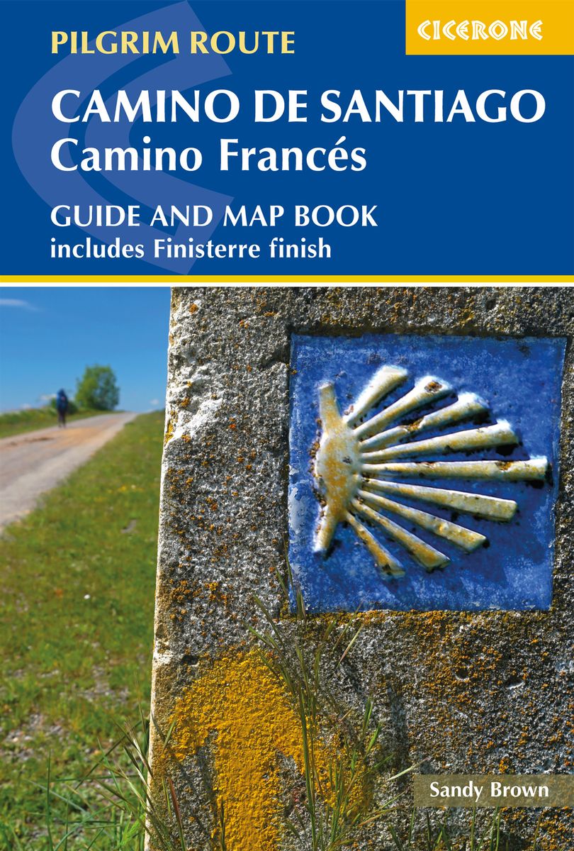
- Camino de Santiago: Camino Frances
- Guide and map book - includes Finisterre finish Read more
- Also available from:
- De Zwerver, Netherlands
De Zwerver
Netherlands
2020
Netherlands
2020
- Wandelgids - Pelgrimsroute Camino de Santiago - Camino Frances | Cicerone
- Guidebook and map book to walking the 784km Camino Frances from St Jean-Pied-de-Port in southern France to Santiago de Compostela in Spain, including an additional route to Finisterre. Split into 6 sections and 36 customisable stages, the guide lists over 500 pilgrim hostels. The map book covers the entire route, which can be walked in 4-5 weeks. Read more


The Book Depository
United Kingdom
United Kingdom

The Book Depository
United Kingdom
United Kingdom
- Caminhando Com as Estrelas
- Vivendo entre histórias, lendas e um turbilhão de emoções no Caminho de Santiago. Read more

The Book Depository
United Kingdom
2020
United Kingdom
2020
- A Pilgrim's Guide to the Camino Ingles
- & Camino Finisterre Including Muxia Circuit Read more


The Book Depository
United Kingdom
2023
United Kingdom
2023
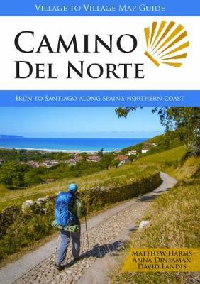
- Camino del Norte
- Irun to Santiago along Spain's Northern Coast Read more
- Also available from:
- De Zwerver, Netherlands
De Zwerver
Netherlands
2023
Netherlands
2023
- Wandelgids Camino Del Norte | Village to Village Press
- Irun to Santiago along Spain's Northern Coast Read more

The Book Depository
United Kingdom
United Kingdom
- Walking Notes Camino Frances
- Day to day from St. Jean Pied de Port to Santiago de Compostela Read more

The Book Depository
United Kingdom
United Kingdom
- 400 Kilometer rückwärts auf dem Camino del Norte
- Allein & off-season von Ribadeo nach Bilbao Read more
Maps

Stanfords
United Kingdom
United Kingdom
- Ezcaray CNIG Topo 240
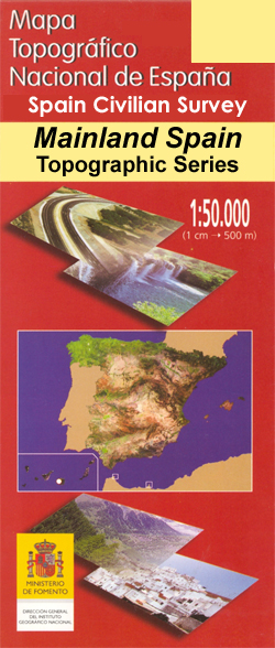
- Topographic coverage of mainland Spain at 1:50,000 in the MTN50 (Mapa Topográfico Nacional) series from the Centro Nacional de Información Geografica, the country’s civilian survey organization. The maps have contours at 20m intervals, enhanced by relief shading, plus colouring and/or graphics to show different types of terrain, vegetation or... Read more

Stanfords
United Kingdom
United Kingdom
- Castañar de Ibor CNIG Topo 681
- Topographic coverage of mainland Spain at 1:50,000 in the MTN50 (Mapa Topográfico Nacional) series from the Centro Nacional de Información Geografica, the country’s civilian survey organization. The maps have contours at 20m intervals, enhanced by relief shading, plus colouring and/or graphics to show different types of terrain, vegetation or... Read more

Stanfords
United Kingdom
United Kingdom
- Miranda de Ebro CNIG Topo 137
- Topographic coverage of mainland Spain at 1:50,000 in the MTN50 (Mapa Topográfico Nacional) series from the Centro Nacional de Información Geografica, the country’s civilian survey organization. The maps have contours at 20m intervals, enhanced by relief shading, plus colouring and/or graphics to show different types of terrain, vegetation or... Read more

Stanfords
United Kingdom
United Kingdom
- Tomelloso CNIG Topo 762
- Topographic coverage of mainland Spain at 1:50,000 in the MTN50 (Mapa Topográfico Nacional) series from the Centro Nacional de Información Geografica, the country’s civilian survey organization. The maps have contours at 20m intervals, enhanced by relief shading, plus colouring and/or graphics to show different types of terrain, vegetation or... Read more

Stanfords
United Kingdom
United Kingdom
- Bedmar CNIG Topo 948
- Topographic coverage of mainland Spain at 1:50,000 in the MTN50 (Mapa Topográfico Nacional) series from the Centro Nacional de Información Geografica, the country’s civilian survey organization. The maps have contours at 20m intervals, enhanced by relief shading, plus colouring and/or graphics to show different types of terrain, vegetation or... Read more

Stanfords
United Kingdom
United Kingdom
- Colmenar CNIG Topo 1039
- Topographic coverage of mainland Spain at 1:50,000 in the MTN50 (Mapa Topográfico Nacional) series from the Centro Nacional de Información Geografica, the country’s civilian survey organization. The maps have contours at 20m intervals, enhanced by relief shading, plus colouring and/or graphics to show different types of terrain, vegetation or... Read more

Stanfords
United Kingdom
United Kingdom
- Toro CNIG Topo 370
- Topographic coverage of mainland Spain at 1:50,000 in the MTN50 (Mapa Topográfico Nacional) series from the Centro Nacional de Información Geografica, the country’s civilian survey organization. The maps have contours at 20m intervals, enhanced by relief shading, plus colouring and/or graphics to show different types of terrain, vegetation or... Read more

Stanfords
United Kingdom
United Kingdom
- Horta de Sant Joan CNIG Topo 496
- Topographic coverage of mainland Spain at 1:50,000 in the MTN50 (Mapa Topográfico Nacional) series from the Centro Nacional de Información Geografica, the country’s civilian survey organization. The maps have contours at 20m intervals, enhanced by relief shading, plus colouring and/or graphics to show different types of terrain, vegetation or... Read more

Stanfords
United Kingdom
United Kingdom
- Mondonedo CNIG Topo 24
- Topographic coverage of mainland Spain at 1:50,000 in the MTN50 (Mapa Topográfico Nacional) series from the Centro Nacional de Información Geografica, the country’s civilian survey organization. The maps have contours at 20m intervals, enhanced by relief shading, plus colouring and/or graphics to show different types of terrain, vegetation or... Read more

Stanfords
United Kingdom
United Kingdom
- Vilvestre CNIG Topo 449
- Topographic coverage of mainland Spain at 1:50,000 in the MTN50 (Mapa Topográfico Nacional) series from the Centro Nacional de Información Geografica, the country’s civilian survey organization. The maps have contours at 20m intervals, enhanced by relief shading, plus colouring and/or graphics to show different types of terrain, vegetation or... Read more

Stanfords
United Kingdom
United Kingdom
- Mira CNIG Topo 665
- Topographic coverage of mainland Spain at 1:50,000 in the MTN50 (Mapa Topográfico Nacional) series from the Centro Nacional de Información Geografica, the country’s civilian survey organization. The maps have contours at 20m intervals, enhanced by relief shading, plus colouring and/or graphics to show different types of terrain, vegetation or... Read more

Stanfords
United Kingdom
United Kingdom
- Marbella CNIG Topo 1065
- Topographic coverage of mainland Spain at 1:50,000 in the MTN50 (Mapa Topográfico Nacional) series from the Centro Nacional de Información Geografica, the country’s civilian survey organization. The maps have contours at 20m intervals, enhanced by relief shading, plus colouring and/or graphics to show different types of terrain, vegetation or... Read more
Stanfords
United Kingdom
United Kingdom
- Gandesa CNIG Topo 470
- Topographic coverage of mainland Spain at 1:50,000 in the MTN50 (Mapa Topográfico Nacional) series from the Centro Nacional de Información Geografica, the country’s civilian survey organization. The maps have contours at 20m intervals, enhanced by relief shading, plus colouring and/or graphics to show different types of terrain, vegetation or... Read more

Stanfords
United Kingdom
United Kingdom
- Boltaña CNIG Topo 211
- Topographic coverage of mainland Spain at 1:50,000 in the MTN50 (Mapa Topográfico Nacional) series from the Centro Nacional de Información Geografica, the country’s civilian survey organization. The maps have contours at 20m intervals, enhanced by relief shading, plus colouring and/or graphics to show different types of terrain, vegetation or... Read more

Stanfords
United Kingdom
United Kingdom
- Potes CNIG Topo 81
- Topographic coverage of mainland Spain at 1:50,000 in the MTN50 (Mapa Topográfico Nacional) series from the Centro Nacional de Información Geografica, the country’s civilian survey organization. The maps have contours at 20m intervals, enhanced by relief shading, plus colouring and/or graphics to show different types of terrain, vegetation or... Read more