
GR10 Senderos de la Miel
Description
- Name GR10 Senderos de la Miel (GR10)
- Length of trail 1,168 km, 726 miles
- Length in days 65 days
- Start of trail Puçol
- End of trail Límite con Portugal
- Traildino grading SW, Strenuous walk, mountain trail
- Hut tour grading T2, Mountain walk


10
Puçol - Límite con Portugal, Senderos de la Miel, GR 10. 1168 km, 65 stages. País Valencià, Aragón, Castilla la Mancha, Madrid and Castilla-León, from Mediteranean to Portugal.
Select some tracks
☐.[GR 10] De Valencia a Lisboa (Etapa desde el Puerto de la Fuenfría a San Lorenzo del Escorial), 32km
☐[GR 10] De Valencia a Lisboa (Variante), 2.3km
☐GR 10.4, 44km
☐GR 10-F, 12km
☐GR 10 -variante, 20km
☐GruBrìa Dorsale GR10 Valassina (Seregno-Monza), 10km
☐[GR 10] De Valencia a Lisboa (Etapa Abejuela - Arcos de las Salinas), 20km
☐[GR 10] De Valencia a Lisboa (Etapa Arcos de las Salinas - Camarena de la Sierra), 9.6km
☐[GR 10] De Valencia a Lisboa (Etapa Camarena de la Sierra - Riodeva), 16km
☐[GR 10] De Valencia a Lisboa (Etapa Riodeva - Villel), 19km
Map

Links
Facts
Reports
Guides and maps
Lodging
Organisations
Tour operators
GPS
Other
Books

Stanfords
United Kingdom
2020
United Kingdom
2020
- Tour du Larzac, Templier - Hospitalier - Entre causses et vallées GR71C/GR71D
- Tour du Larzac - Templier et Hospitalier, FFRP topoguide Ref. No. 710, covering the 195kms of hiking circuits along the GR71C and GR71D south of Millau in the Causse du Larzac, plus 13 local day walks. Current edition of this title was published in December 2015.ABOUT THE FFRP (Fédération française de la randonnée pédestre) TOPOGUIDES:... Read more
Stanfords
United Kingdom
2020
United Kingdom
2020
- Les Abers - le Chemin de Phares GR34/GR34F
- Les Abers - le chemin de phares, FFRP topoguide Ref. no. 347, covering the coastal route in north-western Brittany between Morlaix, Brest, and le Fau, plus 4 walks on the Ile d`Ouessant. Current edition of this title was published in September 2017.Between Morlaix and Brest, where the sea has dug deep furrows in the land. More than 20 days of... Read more

Stanfords
United Kingdom
United Kingdom
- GR3: Les Monts du Forez FFRP Topo-guide No. 334
- Les Monts du Forez, FFRP topoguide Ref. No. 334, covering in all 259kms along the GR3 and its variant, with additional descriptions of 21 day walks in the region. Current edition of this title was published in April 2016.ABOUT THE FFRP (Fédération française de la randonnée pédestre) TOPOGUIDES: published in a handy A5 paperback format, the... Read more

Stanfords
United Kingdom
2018
United Kingdom
2018
- Val d`Azun à pied ST10
- Val d`Azun à pied, FFRP topo-guide Ref. No. ST10, with 18 day walks of varying length and difficulty in the French Pyrenees south-west of Argelès-Gazost, plus a tour which includes part of the GR10 long-distance footpaths. Each walk is presented on a separate colour extract from IGN’s topographic survey of France at 1:25,000 and/or 1:50,000,... Read more

Stanfords
United Kingdom
2011
United Kingdom
2011
- GRP: Monts et Lacs du Lévézou FFRP Topo-guide No. 1201
- Monts et Lacs du Lévézou, FFRP topo-guide ref. no. 1201, covering two hiking circuits in the Massif Central near Rodez and Millau; in all 214kms of routes. Current edition of this title was published in March 2011.ABOUT THE FFRP (Fédération française de la randonnée pédestre) TOPOGUIDES: published in a handy A5 paperback format, the guides are... Read more

Stanfords
United Kingdom
2018
United Kingdom
2018
- Pyrénées Ariégeoises - La traversée des Pyrénées et tours du Val du Garbet et du Biros GR10
- Pyrénées Ariégeoises, FFRP topoguide, Ref. No. 1090, covering the third section of the GR10 along the Pyrenees from the Atlantic to the Mediterranean – a 335-km long walk from Bagnères-de-Luchon to Mérens-les-Vals. Given the mountainous terrain, the guide also provides a detailed route profile for this part of the GR10, annotated with timings... Read more
Stanfords
United Kingdom
2019
United Kingdom
2019
- Sentiers de Saint-Jacques-de-Compostelle - Via Le Puy - Geneve - Le Puy GR65
- Chemins de St-Jacques: Geneva - Le Puy-en-Velay, FFRP topoguide Ref. No. 650, covering a 360km section of the GR65 along one of the routes of the Way of St. James across France. Current edition of this title was published in March 2016.ABOUT THE FFRP (Fédération française de la randonnée pédestre) TOPOGUIDES: published in a handy A5 paperback... Read more

Stanfords
United Kingdom
2012
United Kingdom
2012
- GR93/GR94 Tours dans les Hautes-Alpes FFRP Topo-guide No. 940
- Tours dans les Hautes-Alpes, FFRP topoguide Ref. no. 940, covering 691km of hiking routes along the GR93 and GR94 in the French Alps west of Gap. The routes can be combined, as required, into shorter or longer circuits. Current edition of this title was published in June 2012.ABOUT THE FFRP (Fédération française de la randonnée pédestre)... Read more
Stanfords
United Kingdom
2019
United Kingdom
2019
- La Grande Traversee du Jura GR5/GR9/GTJ
- La Grande Travesée du Jura, FFRP topoguide Ref. no. 512, covering the GTJ along the Jura Mountains in France from Nommay to Culoz, plus several variants off the main route including parts of the GR5 and GR9 – in all 509kms of hiking trails. Current edition of this title was published in March 2017.The GR509 offers hikers a path punctuated by... Read more

Stanfords
United Kingdom
2015
United Kingdom
2015
- GR654 Chemins de St-Jacques: Vézelay - Périgueux FFRP Topo-guide No. 6542
- Chemins de St-Jacques: Vézelay - Périgueux, FFRP topoguide Ref. no. 6542, covering the 744km route along the GR654 the Way of St. Jamezs from Vézelay via Limoges to Périgueux. Current edition of this title was published in March 2015.ABOUT THE FFRP (Fédération française de la randonnée pédestre) TOPOGUIDES: published in a handy A5 paperback... Read more
Stanfords
United Kingdom
2017
United Kingdom
2017
- Pyrenees Centrales et tours du Val d`Azun et d`Oueil-Larboust GR10/GR101
- Pyrénées Centrales, FFRP topoguide, Ref. No. 1091, covering the second section of the GR10 along the Pyrenees from the Atlantic to the Mediterranean – a 270-km long walk from Arrens-Marsous to Bagnères-de-Luchon. Different variants of the GR10 are covered, with or without including the highest part of the mountains at Gavarnie, plus a link to... Read more

Stanfords
United Kingdom
2019
United Kingdom
2019
- Sentier vers Saint-Jacques-de-Compostelle via Arles: Arles - Toulouse GR653
- GR653: Chemins de St. Jacques from Arles to Toulouse, FFRP topo-guide Ref. No. 6533 in a new edition published in July 2019, with colour reproductions of IGN’s topographic mapping at 1:50,000. The guide covers the 465-km long Via Arletanensis route of the Way of St James in France from Arles across Montpellier and Cartres to Toulouse.From... Read more
Stanfords
United Kingdom
2020
United Kingdom
2020
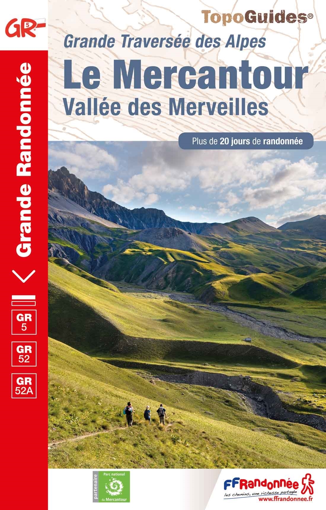
- Le Mercantour - Vallee des Merveilles GR5/GR52/52A
- Le Mercantour: Larche – Nice/Menton, Vallée des Merveilles, FFRP topoguide Ref. No. 507, covering 450km of long-distance routes: the last section of the GR5 in the French Alps from Larche to Nice, an alternative variant off GR5 along the GR52 leading via the Vallée des Merveilles to Menton, plus GR52A – Panoramique du Mecantour from Col du... Read more

Stanfords
United Kingdom
2015
United Kingdom
2015
- GRP: Tours et Ronde du Canigó FFRP Topo-guide No. 6600
- Tours et Ronde du Canigó, FFRP topoguide Ref. no. 6600, covering 395kms of routes in the eastern Pyrenees, including a tour of Canigou itself and sections of the GR10. Current edition of this title was published in June 2015.ABOUT THE FFRP (Fédération française de la randonnée pédestre) TOPOGUIDES: published in a handy A5 paperback format, the... Read more

Stanfords
United Kingdom
2017
United Kingdom
2017
- Chemins de St. Jacques: Toulouse - Jaca - Lourdes GR653/GR101/GR78
- The last stretch of the Toulouse route before reaching Spain and the Camino Frances.Chemins de St. Jacques: Toulouse - Jaca, FFRP topoguide Ref. No. 6534, covering one of the southern routes of the Way of St. James in France: from Toulouse along the GR 653, with variants through Pau or Tarbes, across Col du Somport to Jaca in the Spanish... Read more
Maps
Stanfords
United Kingdom
2019
United Kingdom
2019
- Tours et Traversées du Vercors - du Diois et les Baronnies GR9/GR91
- Tours et Traversées dans Vercors, le Diois et les Baronnies, FFRP topo-guide Ref. No. 904, covering in all over 1000 km of routes and circuits along the GR9, GR91, GR93, GR95, GR429 and GRs de Pays between Grenoble, Die and Brantes in Provence north of Mt Ventoux. Topographic mapping from the IGN is accompanied by detailed route descriptions,... Read more

Stanfords
United Kingdom
United Kingdom
- Pays Basque West Rando Editions 1 SUPERCEDED
- The westernmost section of the French Pyrenees between the Atlantic coast and St-Jean-Pied-de-Port on a contoured and GPS compatible map at 1:50,000 from Rando Editions with topographic base provided by the IGN, highlighting local and long-distance hiking trails, cycle and mountain bike routes, etc. Coverage along the Atlantic coast starts at... Read more
Stanfords
United Kingdom
2016
United Kingdom
2016
- Sur les Traces des Cathares GR107 FR et ES Plus de 10 Jours de Randonnee: FFR.1097: 2016
- Sur les traces des Cathares, Le Chemin des Bonshommes GR 10 Topo Guide FFRP ref 1097 Hiking guide for the French Pyrenees with description of a multi-day hike of 220 km for 10 days hiking through the Cathar country from Foix, Ariege along Andorra to Berga ( Pyrenees France and Spain).French-speaking hiking guide. Excellent description with... Read more
Stanfords
United Kingdom
United Kingdom
- Massif des Vosges - Plaine d`Alsace IGN Top200 201
- Pyrénées Ouest map from the IGN at 1:200,000, with excellent presentation of the terrain through contours and vivid relief shading, plenty of names of topographic features, long-distance GR hiking routes, places of interest, etc. The map is designed to provide convenient coverage of the western and central part of the Pyrenees, extending across... Read more

Stanfords
United Kingdom
2019
United Kingdom
2019
- Pyrénées Orientales et tours du Capcir, du Carlit et de Cerdagne GR10/GR36
- More than 30 days of hiking, including 12 to join Banyuls in Mérens-les-Vals.Pyrénées Orientales, FFRP topoguide, Ref. No. 1092, covering the fourth and last section of the GR10 along the Pyrenees from the Atlantic to the Mediterranean – a 196-km long walk from Mérens-les-Vals to Banyuls-sur-Mer. The guide also covers a 177-km trail along the... Read more
Stanfords
United Kingdom
United Kingdom
- Massif Central IGN Top200 204
- Pyrénées Ouest map from the IGN at 1:200,000, with excellent presentation of the terrain through contours and vivid relief shading, plenty of names of topographic features, long-distance GR hiking routes, places of interest, etc. The map is designed to provide convenient coverage of the western and central part of the Pyrenees, extending across... Read more

Stanfords
United Kingdom
United Kingdom
- Tour of the Canigó Hiking Circuit
- A 64-km long tour of Canigó (Canigou), the highest mountain in the eastern Pyrenees, presented by Editorial Alpina on a contoured, GPS compatible map at 1:25,000, with a booklet providing descriptions of its recommended stages.The map has contours at 20m intervals, enhanced by relief shading. The tour which follows sections of the GR10, the HRP... Read more

Stanfords
United Kingdom
2017
United Kingdom
2017
- Le Chemin du Piemont Pyreneen - vers Saint-Jacques-de-Compostell
- Le Chemin du Piémont Pyrénéen, FFRP topoguide, Ref. No. 780, covering the GR78 - the Way of St. James along the northern side of the Pyrenees from Carcassonne to Roncesvalles on the Spanish side, with an alternative variant to cross the mountains along the Col du Somport. Current edition of this title was published in May 2017.The route, the... Read more

Stanfords
United Kingdom
United Kingdom
- Canigou-Garrotxa Rando Editions 10
- Canigou Massif and the surrounding region of the French Pyrenees on a contoured and GPS compatible map at 1:50,000 from Rando Editions with topographic base provided by the IGN, highlighting local and long-distance hiking trails, mountain biking routes, etc. Topography is vividly presented by contours at 20m intervals enhanced by shading and... Read more
- Also available from:
- The Book Depository, United Kingdom
- De Zwerver, Netherlands


Stanfords
United Kingdom
United Kingdom
- High Jura - Northern Alps IGN Top200 202
- Pyrénées Ouest map from the IGN at 1:200,000, with excellent presentation of the terrain through contours and vivid relief shading, plenty of names of topographic features, long-distance GR hiking routes, places of interest, etc. The map is designed to provide convenient coverage of the western and central part of the Pyrenees, extending across... Read more
- Also available from:
- The Book Depository, United Kingdom

The Book Depository
United Kingdom
United Kingdom
- Haut-Jura / Alpes du Nord
- Pyrénées Ouest map from the IGN at 1:200,000, with excellent presentation of the terrain through contours and vivid relief shading, plenty of names of topographic features, long-distance GR hiking routes, places of interest, etc. The map is designed to provide convenient coverage of the western and central part of the Pyrenees, extending across... Read more

Stanfords
United Kingdom
United Kingdom
- Béarn - Aspe - Ossau - Pyrenees National Park Rando Editions 3
- French Pyrenees of the Béarn region, from Tardets-Sorholus to the western part of the Pyrenees National Park including the Ossau and Balaïtous massifs, on a contoured and GPS compatible map at 1:50,000 from Rando Editions with topographic base provided by the IGN, highlighting local and long-distance hiking trails, cycle and mountain bike... Read more
- Also available from:
- The Book Depository, United Kingdom
- De Zwerver, Netherlands

The Book Depository
United Kingdom
United Kingdom
- Bearn - Aspe - Ossau - Pyrenees NP
- Uitstekende wandelkaart met veel toeristische informatie en bijzonder gedetailleerd. Wandelroute en hutten / campings zijn ingetekend, met hoogtelijnen. Andere dorpen op deze kaart: Etsaut - Col du Somport - Fabrèges - Col du Pourtalet - la Pierre Saint Martin - Arette - Arudy - Laruns - Arrens Marsous - Argelès Gazost (Frankrijk - Pyreneeen)... Read more

De Zwerver
Netherlands
Netherlands
- Wandelkaart 03 Béarn - Bearn | Rando Editions
- Uitstekende wandelkaart met veel toeristische informatie en bijzonder gedetailleerd. Wandelroute en hutten / campings zijn ingetekend, met hoogtelijnen. Andere dorpen op deze kaart: Etsaut - Col du Somport - Fabrèges - Col du Pourtalet - la Pierre Saint Martin - Arette - Arudy - Laruns - Arrens Marsous - Argelès Gazost (Frankrijk - Pyreneeen)... Read more

Stanfords
United Kingdom
United Kingdom
- Southern Alps IGN Top200 203
- Pyrénées Ouest map from the IGN at 1:200,000, with excellent presentation of the terrain through contours and vivid relief shading, plenty of names of topographic features, long-distance GR hiking routes, places of interest, etc. The map is designed to provide convenient coverage of the western and central part of the Pyrenees, extending across... Read more
- Also available from:
- The Book Depository, United Kingdom

The Book Depository
United Kingdom
United Kingdom
- Alpes du Sud
- Pyrénées Ouest map from the IGN at 1:200,000, with excellent presentation of the terrain through contours and vivid relief shading, plenty of names of topographic features, long-distance GR hiking routes, places of interest, etc. The map is designed to provide convenient coverage of the western and central part of the Pyrenees, extending across... Read more
Stanfords
United Kingdom
2020
United Kingdom
2020
- Tours et Traversées du Massif des Bauges GR96
- Tours et Traversées du Massif des Bauges, FFRP topoguide Ref. no. 902, covering 500kms of routes in the French Alps between Annecy, Aix-les-Bains, Chambéry and Albertville. Current edition of this title was published in May 2015.ABOUT THE FFRP (Fédération française de la randonnée pédestre) TOPOGUIDES: published in a handy A5 paperback format,... Read more
- Also available from:
- The Book Depository, United Kingdom

The Book Depository
United Kingdom
2020
United Kingdom
2020
- Tour et travers�es du Massif des Bauges GR96/GRP
- Tours et Traversées du Massif des Bauges, FFRP topoguide Ref. no. 902, covering 500kms of routes in the French Alps between Annecy, Aix-les-Bains, Chambéry and Albertville. Current edition of this title was published in May 2015.ABOUT THE FFRP (Fédération française de la randonnée pédestre) TOPOGUIDES: published in a handy A5 paperback format,... Read more
Stanfords
United Kingdom
2021
United Kingdom
2021
- Le long des Chateaux de la Loire GR3/GR3B
- Le long des Châteaux de la Loire, FFRP topoguide Ref. No. 333, covering 552km route along the Loire from Bonny-sur-Loire across Orléans, Blois and Tours to Angers. Current edition of this title was published in May 2018.The Loire is world famous for its castles and gardens, now classified as World Heritage by UNESCO. The site of the Loire... Read more
- Also available from:
- The Book Depository, United Kingdom

The Book Depository
United Kingdom
2021
United Kingdom
2021
- Le long des ch�teaux de la Loire GR3/GR3B
- Le long des Châteaux de la Loire, FFRP topoguide Ref. No. 333, covering 552km route along the Loire from Bonny-sur-Loire across Orléans, Blois and Tours to Angers. Current edition of this title was published in May 2018.The Loire is world famous for its castles and gardens, now classified as World Heritage by UNESCO. The site of the Loire... Read more
Stanfords
United Kingdom
United Kingdom
- Pyrenees West IGN Top200 205
- Pyrénées Ouest map from the IGN at 1:200,000, with excellent presentation of the terrain through contours and vivid relief shading, plenty of names of topographic features, long-distance GR hiking routes, places of interest, etc. The map is designed to provide convenient coverage of the western and central part of the Pyrenees, extending across... Read more
- Also available from:
- The Book Depository, United Kingdom

The Book Depository
United Kingdom
United Kingdom
- Pyrenees Western
- Pyrénées Ouest map from the IGN at 1:200,000, with excellent presentation of the terrain through contours and vivid relief shading, plenty of names of topographic features, long-distance GR hiking routes, places of interest, etc. The map is designed to provide convenient coverage of the western and central part of the Pyrenees, extending across... Read more