
Vosges
Description

Range of low mountains west of the Rhine Valley.
Map

Trails in this region
Links
Facts
Reports
Guides and maps
Lodging
Organisations
Tour operators
GPS
Other
Books

Stanfords
United Kingdom
United Kingdom
- Gerardmer Hike & Bike Map
- This new series of hiking and riding maps of various regions are characterized by a clear use of colour and ease of use. With miles of signed small and large loop-shaped walks.- relief and contour lines with an interval of 5 meters - multitude of interesting locations (restaurants, hotels, holiday homes, bakers, butchers, eateries, pharmacists,... Read more

Stanfords
United Kingdom
2014
United Kingdom
2014
- Vogesen - die schönsten Tal- und Höhenwanderungen
- Rother’s Walking Guide to the Côte d`Azur covers 44 day and multiple-day excursions between Meton and Marseille. The guide includes tours that range from walks on the Îles de Lérins over beach hikes at St.Tropez to solid mountain tours in the Massiv de I`Estérel or the Lake Alps; the famous crossing of the Calanques and a long-distance tour in... Read more

Stanfords
United Kingdom
United Kingdom
- Randonnées en Franche-Comté de gare en gare FFRP Topo-guide No. RE18
- Randonnées en Franche-Comté de gare en gare, FFRP topo-guide Ref. No. RE18, with 28 day walks of varying length and difficulty in the French Jura between Belfort and St-Claude. Each walk links two SNCF stations and is presented on a separate colour extract from IGN’s topographic survey of France at 1:25,000, with its description... Read more

Stanfords
United Kingdom
2013
United Kingdom
2013
- La Haute-Sâone à pied FFRP Topo-guide No. D070
- La Haute-Sâone à pied, FFRP topo-guide ref. no. D070, one of the titles in an extensive series of light, A5-size, high quality paperback guides published by the Fédération Française de la Randonnée Pédestre in association with local authorities, ramblers’ clubs, etc. The guides have *colour extracts from the French topographic survey at... Read more

Stanfords
United Kingdom
United Kingdom
- Oxford, Chipping Norton & Bicester OS Landranger Active Map 164 (waterproof)
- Oxford area, including sections of the Thames Path and the E2 European Long-distance Path, on a waterproof and tear-resistant OS Active version of map No. 164 from the Ordnance Survey’s Landranger series at 1:50,000, with contoured and GPS compatible topographic mapping plus tourist information.MOBILE DOWNLOADS: As well as the physical edition... Read more

Stanfords
United Kingdom
United Kingdom
- Ely, Wisbech & Downham Market OS Landranger Active Map 143 (waterproof)
- Cambridgeshire around Ely, Wisbech and Downham Market, including part of the E2 European Long-distance Path, on a waterproof and tear-resistant OS Active version of map No. 143 from the Ordnance Survey’s Landranger series at 1:50,000, with contoured and GPS compatible topographic mapping plus tourist information.MOBILE DOWNLOADS: As well as the... Read more

Stanfords
United Kingdom
2019
United Kingdom
2019
- La Grande Traversee du Jura GR5/GR9/GTJ
- La Grande Travesée du Jura, FFRP topoguide Ref. no. 512, covering the GTJ along the Jura Mountains in France from Nommay to Culoz, plus several variants off the main route including parts of the GR5 and GR9 – in all 509kms of hiking trails. Current edition of this title was published in March 2017.The GR509 offers hikers a path punctuated by... Read more
Stanfords
United Kingdom
2020
United Kingdom
2020
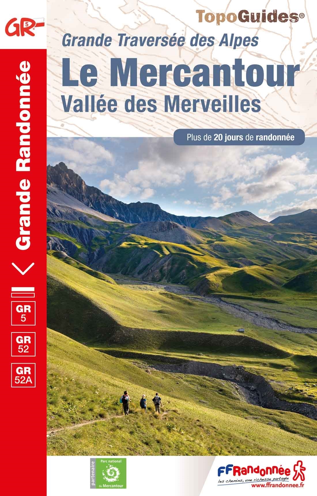
- Le Mercantour - Vallee des Merveilles GR5/GR52/52A
- Le Mercantour: Larche – Nice/Menton, Vallée des Merveilles, FFRP topoguide Ref. No. 507, covering 450km of long-distance routes: the last section of the GR5 in the French Alps from Larche to Nice, an alternative variant off GR5 along the GR52 leading via the Vallée des Merveilles to Menton, plus GR52A – Panoramique du Mecantour from Col du... Read more

Stanfords
United Kingdom
United Kingdom
- Ipswich, The Naze & Clacton-on-Sea OS Landranger Active Map 169 (waterproof)
- Ipswich with Harwich and The Naze area, including part of the E2 European Long-distance Path, on a waterproof and tear-resistant OS Active version of map No. 169 from the Ordnance Survey’s Landranger series at 1:50,000, with contoured and GPS compatible topographic mapping plus tourist information.MOBILE DOWNLOADS: As well as the physical... Read more

Stanfords
United Kingdom
United Kingdom
- Stratford-upon-Avon, Warwick & Banbury OS Landranger Active Map 151 (waterproof)
- The area between Stratford-upon-Avon, Warwick and Banbury, including the northern part of the Cotswold Hills and part of the Cotswold Way / E2 European Long-distance Path, on a waterproof and tear-resistant OS Active version of map No. 151 from the Ordnance Survey’s Landranger series at 1:50,000, with contoured and GPS compatible topographic... Read more
Stanfords
United Kingdom
2020
United Kingdom
2020
- La Traversee der Alpes La Vanoise - PN de la Vanoise GR5/GR55
- 15 days in altitude from the Tarentaise to Modane, heart of the Maurienne. Description also of Via Alpina.La Vanoise (including Parc National de la Vanoise), FFRP topoguide Ref. no. 530, covering the second section of the GR5 in the French Alps between Landry and Modane, its lower variant on the GR5E along the river Arc, plus the traverse of... Read more

Stanfords
United Kingdom
United Kingdom
- Cambridge, Newmarket & Saffron Walden OS Landranger Active Map 154 (waterproof)
- Parts of Cambridgeshire, Suffolk and Essex with Cambridge, Newmarket and Saffron Walden, including part of the E2 European Long-distance path, on a waterproof and tear-resistant OS Active version of map No. 154 from the Ordnance Survey’s Landranger series at 1:50,000, with contoured and GPS compatible topographic mapping plus tourist... Read more

Stanfords
United Kingdom
United Kingdom
- Bury St Edmunds, Sudbury & Stowmarket OS Landranger Active Map 155 (waterproof)
- Suffolk around Bury St Edmunds, Sudbury and Stowmarket, including part of the E2 European Long-distance path, on a waterproof and tear-resistant OS Active version of map No. 155 from the Ordnance Survey’s Landranger series at 1:50,000, with contoured and GPS compatible topographic mapping plus tourist information.MOBILE DOWNLOADS: As well as... Read more

Stanfords
United Kingdom
2019
United Kingdom
2019
- Du Léman à la Vanoise - par le Mont Blanc et le Beaufortain GR5
- The first, 206-km long Alpine section of the GR5 from Lake Geneva, past Mont Blanc and across the Col de la Croix-du-Bonhomme, to Landry north of the Vanoise Massif, FFRP topo-guide ref. no. 504, with colour maps from the IGN TOP25 series at 1:25,000. Also included is a tour of the Dents du Midi. Current edition of this title was published in... Read more

Stanfords
United Kingdom
2019
United Kingdom
2019
- La Traversée des Alpes de la Maurienne a l`Ubaye GR5/GR56
- 9 days from Modane to Larche by the GR5, as much for the tour of Ubaye.Grande Traversée des Alpes: de la Maurienne a l`Ubaye, FFRP topoguide Ref. No. 531, covering the third stage of the GR5 in the French Alps from Modane to Larche, plus the Tour de l`Ubaye at its southern end, in all 272km for hiking routes. Current edition of this title was... Read more
Maps

Stanfords
United Kingdom
United Kingdom
- Luxembourg North
- One of two topographic survey maps of Luxembourg at 1:50,000, with contours at 10-metres intervals and additional relief shading. An overprint highlights long-distance footpaths, including the GR5 (E-2), cycle routes, and various places of interest, including campsites. The map covers an area of approximately 53 x 43 km / 33 x 27 miles. Map... Read more

Stanfords
United Kingdom
United Kingdom
- Alsace - Mulhouse - Basel - Altkirch K+F Outdoor Map 2
- The southern part of Alsace around Mulhouse and Guebwiller on a GPS compatible, double-sided map at 1:50,000 from Kümmerly+Frey printed on sturdy, waterproof and tear-resistant synthetic paper; contoured, with hiking and cycling routes, sites for other recreational activities, various accommodation options, restaurants and ferme-auberge... Read more

Stanfords
United Kingdom
United Kingdom
- Alsace - Vosges Central - Strasbourg - Colmar 2-Map Set Kompass 2221
- The central part of the Vosges Mountain in France on a set of two double-sided, GPS compatible recreational maps at 1:50,000 from Kompass with an extensive overprint highlighting local footpaths and long-distance GR routes, cycling and mountain biking routes, horse riding trails, accommodation facilities, etc.This central set, one of three to... Read more

Stanfords
United Kingdom
United Kingdom
- Luxembourg South
- One of two topographic survey maps of Luxembourg at 1:50,000, with contours at 10-metres intervals and additional relief shading. An overprint highlights long-distance footpaths, including the GR5 (E-2), cycle routes, and various places of interest, including campsites. The map covers an area of approximately 53 x 43 km / 33 x 27 miles. Map... Read more

Stanfords
United Kingdom
2016
United Kingdom
2016
- Vanoise National Park - Beaufortain Didier Richard 04
- Vanoise National Park and the Beaufortain Massif in the French Alps at 1:60,000 on a contoured and GPS compatible map from Didier Richard with a base derived from IGN’s topographic survey, highlighting both local hiking routes and the GR network of long-distance paths, gîtes and mountain refuges, interesting natural and cultural sites, etc. The... Read more

Stanfords
United Kingdom
United Kingdom
- Alsace - Vosges South - Colmar - Mulhouse 2-Map Set Kompass 2222
- The southern part of the Vosges Mountain in France on a set of two double-sided, GPS compatible recreational maps at 1:50,000 from Kompass with an extensive overprint highlighting local footpaths and long-distance GR routes, cycling and mountain biking routes, horse riding trails, accommodation facilities, etc.This southern set, one of three to... Read more

Stanfords
United Kingdom
United Kingdom
- Autour du Thabor: Modane - Bardonecchia - Briançon
- Mont Thabor area at 1:50,000 on a contoured and GPS compatible map from Editions Didier Richard in their series of walking maps of French Alps and other popular hiking regions of south-eastern France. Coverage extends from Modane in the north to Briançon in the south-east, and west to Valloire.The base map with cartography from the IGN has... Read more

Stanfords
United Kingdom
United Kingdom
- Grand Est - Massif des Vosges - Alsace-Lorraine IGN Regional NR05 DOUBLE-SIDED
- IGN publishes its new collection of regional maps including the official division of the 13 new regions. The largest regions are well represented on a single map. These maps are double sided and in 6 languages. Read more

Stanfords
United Kingdom
United Kingdom
- Mulhouse and its Environs IGN Map
- Mulhouse and its Environs in a series of detailed road maps at 1:80,000 from the IGN, designed to highlight places of interest and recreational possibilities, with a city centre street plan and an enlargement of a selected hiking area.Cartography is an enlargement from 1:100,000 to 1:80,000 of the publisher’s highly popular TOP100 series, with... Read more

Stanfords
United Kingdom
United Kingdom
- Vosges - Lac Blanc Supertrail Map
- The Vosges in Alsace. A medium-high mountain range in thest of France. The mountain range starts at the border and extends north on the western side of the Rhine Valley. The round peaks of the Great Vosges are called balloons, French for spherical mountains.The new Supertrail Maps show the best singletrails in Europe’s hottest mountain bike... Read more

Stanfords
United Kingdom
United Kingdom
- Alsace Wine Wall Map
- Wine wall map of Alsace showing the region’s wine growing areas according to their A.O.C. classification and the course of the famous Route des Vins, plus a list of Grands Crus and an inset with geological information. The map covers the southern slopes of the Vosges Mountains between Strasbourg and Mulhouse, with an inset for showing the... Read more

Stanfords
United Kingdom
United Kingdom
- Bregenz F&B
- Indexed street plan of Bregenz extending north along the Bodensee coast to Lochau and Unter Hochsteg. Detail includes pedestrianised areas, railways, bus routes and cycle paths. Notable buildings are highlighted in red, and symbols indicate post offices, hostels, campsites and car parks.On the reverse is a 1:50,000 contoured map of the... Read more

Stanfords
United Kingdom
United Kingdom
- Alsace - Vosges North - Hagenau - Starsburg 2-Map Set Kompass 2220
- The northern part of the Vosges Mountain in France on a set of two double-sided, GPS compatible recreational maps at 1:50,000 from Kompass with an extensive overprint highlighting local footpaths and long-distance GR routes, cycling and mountain biking routes, horse riding trails, accommodation facilities, etc.This northern set, one of three to... Read more

Stanfords
United Kingdom
United Kingdom
- Alsace Wine Map
- Wine map of Alsace showing the region’s wine growing areas according to their A.O.C. classification and the course of the famous Route des Vins, plus a list of Grands Crus and an inset with geological information. The map covers the southern slopes of the Vosges Mountains between Strasbourg and Mulhouse, with an inset for showing the northern... Read more
Stanfords
United Kingdom
United Kingdom
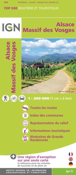
- Massif des Vosges - Plaine d`Alsace IGN Top200 201
- Pyrénées Ouest map from the IGN at 1:200,000, with excellent presentation of the terrain through contours and vivid relief shading, plenty of names of topographic features, long-distance GR hiking routes, places of interest, etc. The map is designed to provide convenient coverage of the western and central part of the Pyrenees, extending across... Read more