
La Palma, Canarias
Description
 La Palma is a popular hiking destination as much as a popular sun destination. You may like both, and take advantage of the very good flight connections to the island. Most prominent feature is the huge erosion crater, Caldera de Taburiente, a National Park. Highest summit here is the Roque de la Muchachos, 2426 m.
The long side of the pear shaped island points to the south. This is where volcanic features are found which can be explored on foot; just follow the GR131 marked trail. By the way: this trail is also part of the European Long Distance Path E7.
The other GR on the island is the GR130, a circular walk around the island, more level than the GR130, connecting a series of villages.
In addition to the spectacular rocky mountainous center of the island, with its volcanoes and craters, the forests in the north and northeast are a second must-see. The trade winds from the north hit the island, the air is lifted, causing a zone of semi-perpetual clouds and mist. The green moist forests with large ferns and evergreen laurel trees, often hidden in steep ravines, are an oasis compared to the dry south. We mentioned the two GR's on the island. Apart from these, many regional or local routes, well-marked, give you the opportunity to explore these micro biotopes such as the steep barrancas on the north coast or the string of volcanoes on the south crest.
Check the complete list of Canary Islands.
Map

Trails in this region
Links
Facts
Reports
Guides and maps
Lodging
Organisations
Tour operators
GPS
Other
Books

United Kingdom
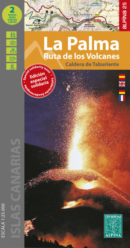
- La Palma - Caldera de Taburiente 2-Map Set Editorial Alpina
- This set of 2 maps covers the island of La Palma in the Canary Islands at 1/25 000 (1cm = 250m) and includes all the hiking trails. Also includes the route of the ten most beautiful walks and 7 marked mountain biking itineraries as well as many points of interest. Read more

United Kingdom
- Mallorca 4-Map Set Kompass 2230
- Mallorca on a set of four double-sided, contoured and GPS compatible maps at 1:35,000 from Kompass with exceptionally detailed presentation of the topography, extensive overprint for hiking trails and cycling routes, accommodation and places of interest, etc, plus street plans of central Palma de Mallorca, Platja de Palma, Sóller, Alcúdia/Port... Read more

United Kingdom
2015
- La Palma GERMAN
- This Rother Walking Guide to La Palma (ALL TEXT IS IN GERMAN), presents the hiker with 64 varied and entertaining tour suggestions incorporating every region on the island - the guide includes 112 colour photos and colour hiking maps at 1:50.000 or 1:100,000 scale, and an overview map for general planning at 1:250,000. From physically demanding... Read more

United Kingdom
- Caldera de Taburiente NP - La Palma CNIG Map-Guide SPANISH
- Caldera de Taburiente National Park on La Palma at 1:25,000 on a contoured and GPS compatible map from IGN/CNIG with cartography from their topographic survey of Spain. The map is accompanied by a SPANISH language guide with descriptions of walks, contact details for recommended accommodation, etc. The map has contours at 10m intervals enhanced... Read more

United Kingdom
2023
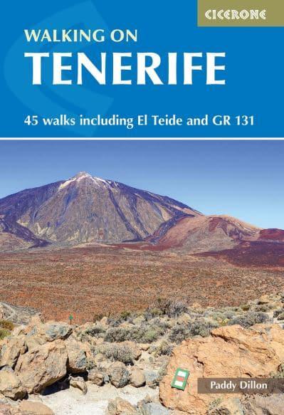
- Walking on Tenerife
- 45 walks including El Teide and GR 131 Read more
- Also available from:
- De Zwerver, Netherlands
Netherlands
2023
- Wandelgids Walking on Tenerife | Cicerone
- 45 walks including El Teide and GR 131 Read more

United Kingdom
- La Palma: Road Map - Hiking Paths - Tourist Information [Multilingual]
- Road Map - Hiking Paths - Tourist Information Read more

United Kingdom
- La Palma
- This Rother Walking Guide to La Palma presents the hiker with a wide variety of entertaining tour suggestions incorporating every region on the island - the guide includes 112 colour photos and colour hiking maps at 1:50.000 or 1:100,000 scale, and an overview map for general planning at 1:250,000. From physically demanding excursions to the... Read more
- Also available from:
- The Book Depository, United Kingdom

United Kingdom
- La Palma walking guide 71 walks 2020
- The Finest Valley and Mountain Walks - ROTH.E4808 Read more

United Kingdom
2019
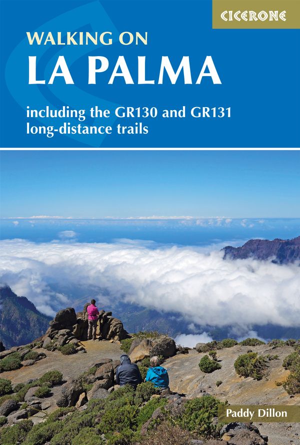
- Walking on La Palma
- Including the GR130 and GR131 long-distance trails Read more
- Also available from:
- De Zwerver, Netherlands
Netherlands
2019
- Wandelgids Walking on La Palma | Cicerone
- Guidebook to 45 walks and scrambles on La Palma in the Canary Islands, ranging from 7 to 31km. Some walks combine to complete the GR130 long-distance trail (eight days) and GR131 trail (three days). Areas explored include Santa Cruz and Buenavista. Contains a Spanish-English glossary. Read more

United Kingdom
2022
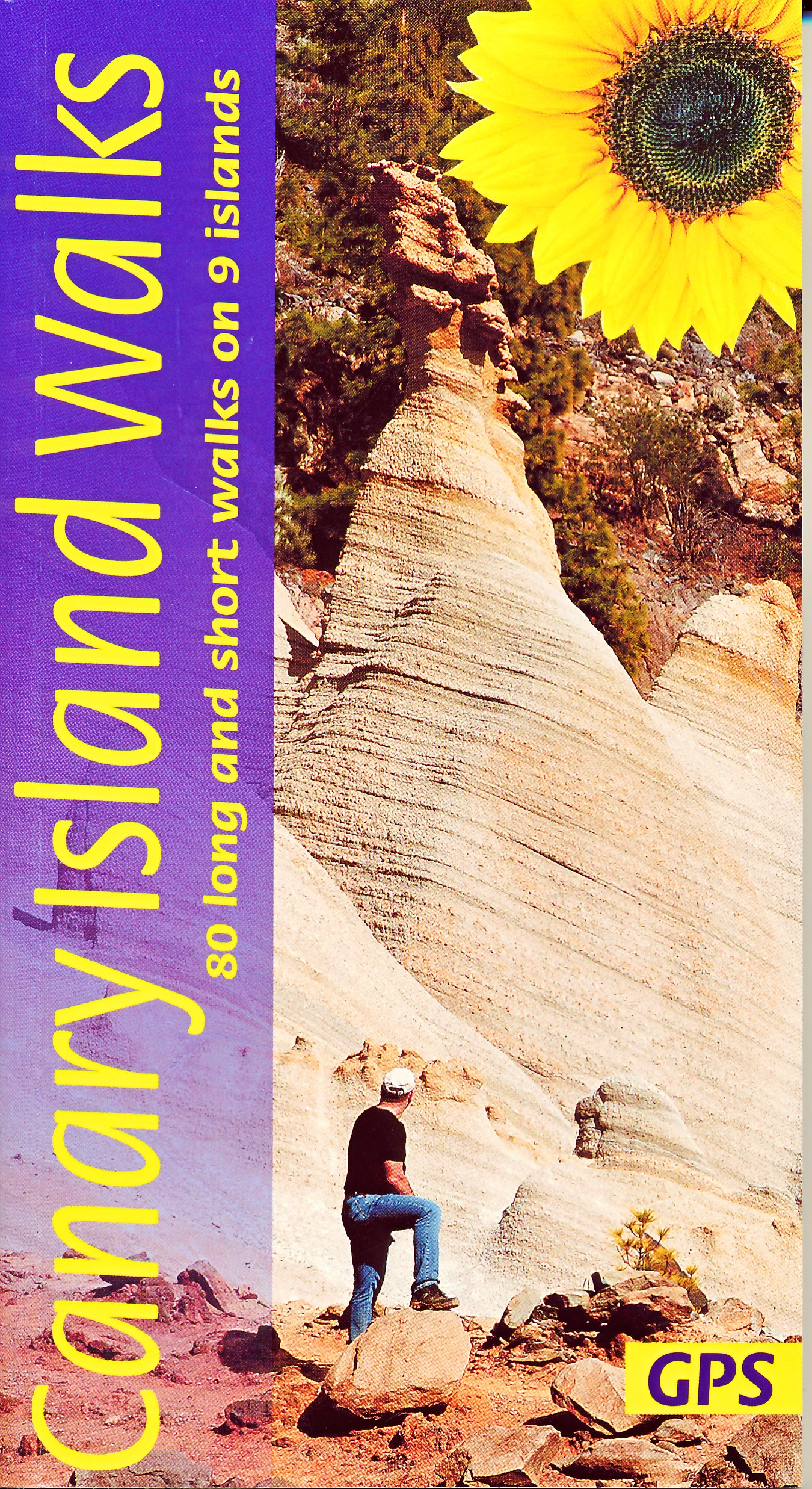
- Canary Islands Walks Sunflower Guide: 90 long and short walks on the Canary Islands
- The go-to travel guide for discovering the best walks on the Canary Islands; Strap on your boots and discover the Canary Islands on foot with the Sunflower Canary Islands Walks travel guide. The Sunflower Canary Islands Walks guide is indispensable for walking and hiking on all 7 Canary Islands - Tenerife, Gran Canaria, Lanzarote,... Read more
- Also available from:
- The Book Depository, United Kingdom
- De Zwerver, Netherlands

United Kingdom
2022
- Canary Islands Walks Sunflower Guide
- 80 long and short walks on the Canary Islands Read more
Netherlands
2022
- Wandelgids Canary Islands Walks | Sunflower books
- The go-to travel guide for discovering the best walks on the Canary Islands; Strap on your boots and discover the Canary Islands on foot with the Sunflower Canary Islands Walks travel guide. The Sunflower Canary Islands Walks guide is indispensable for walking and hiking on all 7 Canary Islands - Tenerife, Gran Canaria, Lanzarote,... Read more

- Also available from:
- De Zwerver, Netherlands
Netherlands
2018

United Kingdom

United Kingdom
2019
- Trekking in the Canary Islands: The GR131 island-hopping route
- This guidebook provides a comprehensive and detailed description of the GR131, an island-hopping trail across the seven Canary Islands. The 560km (348 mile) route begins on Lanzarote and finishes on El Hierro and is presented in 32 daily stages. The route is well waymarked but some navigational skills are required, and the remote and occasional... Read more
- Also available from:
- The Book Depository, United Kingdom
- De Zwerver, Netherlands

United Kingdom
2019
- Trekking in the Canary Islands
- The GR131 island-hopping route Read more

Netherlands
2019
- Wandelgids Trekking in the Canary Islands: The GR131 Island Hopping Route | Cicerone
- Guidebook to the GR131, an island-hopping trail that runs coast to coast across each of the 7 Canary Islands, a sub-tropical Spanish archipelago. Described over 32 stages, the route begins on Lanzarote, finishes on El Hierro, measures 560km (348 miles) and would take an average trekker about 1 month to complete. Read more

United Kingdom
2020
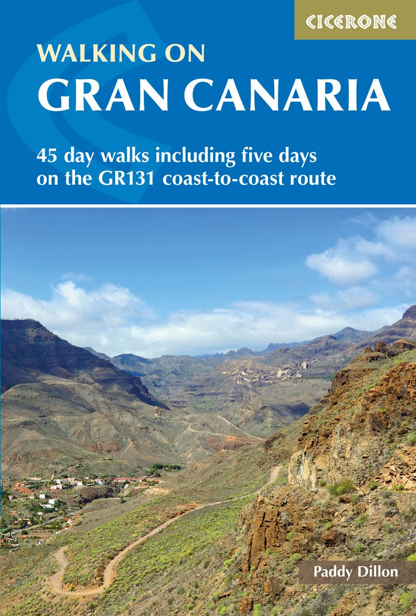
- Walking on Gran Canaria
- 45 day walks including five days on the GR131 coast-to-coast route Read more
- Also available from:
- De Zwerver, Netherlands
Netherlands
2020
- Wandelgids Walking on Gran Canaria | Cicerone
- Guidebook describing 45 day walks on Gran Canaria, generally averaging 10 to 12km each. A long-distance coast-to-coast route on the GR131 is included, and shorter walks can be linked to form longer itineraries. One of the larger Canary Islands, Gran Canaria is a popular destination but offers many peaceful, rural areas perfect for walking. Read more

United Kingdom
- Also available from:
- De Zwerver, Netherlands

United Kingdom
2018
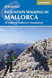
- Mountain Walking in Mallorca: 50 routes in Mallorca`s Tramuntana
- This guide describes 50 full and half-day walks in Mallorca`s mountainous northwest, in the stunning Serra de Tramuntana. Whilst the region promises breathtaking scenery and some fantastic walks, there is also some potentially challenging terrain, making guidance when choosing, planning and walking routes all the more valuable. Ranging from... Read more
- Also available from:
- The Book Depository, United Kingdom
- De Zwerver, Netherlands

United Kingdom
2018
- Mountain Walking in Mallorca
- 50 routes in Mallorca's Tramuntana Read more
Netherlands
2018
- Wandelgids Mountain Walking in Mallorca | Cicerone
- Guidebook describing 50 full and half-day walks in Mallorca's mountainous northwest. Ranging from 5.5km to 24km, the routes showcase the outstanding natural beauty and mountain heritage of the Serra de Tramuntana. Potential bases include Pollença, Sóller, Valldemossa and Andratx, and most walks are accessible by public transport. Read more
Maps

United Kingdom
- San Juan de Puntallana - La Palma CNIG Topo 1083-4
- Topographic coverage of the Canary Islands at 1:25,000 published by the Instituto Geográfico Nacional – Centro Nacional de Información Geografica, the country’s civilian survey organization. The maps have contours at 10m intervals and colouring and/or graphics to show different types of vegetation or land use. Boundaries of national parks and... Read more

United Kingdom
- La Palma de Condado CNIG Topo 982
- Topographic coverage of mainland Spain at 1:50,000 in the MTN50 (Mapa Topográfico Nacional) series from the Centro Nacional de Información Geografica, the country’s civilian survey organization. The maps have contours at 20m intervals, enhanced by relief shading, plus colouring and/or graphics to show different types of terrain, vegetation or... Read more

United Kingdom
- Canary Islands West: Gran Canaria, Tenerife, La Palma, Gomera, Hierro 500K CNIG Regional Map No. 14
- Western Canary Islands (Gran Canaria, Tenerife, La Palma, Gomera and Hierro) at 1:500,000 in a series of regional road map of Spain from the country’s civilian survey organization IGN-CNIG (Instituto Geográfico Nacional - Centro Nacional de Información Geográfica), vividly presenting the topography by altitude colouring, boundaries of... Read more
United Kingdom
- Los Llanos de Aridane 25K La Palma CNIG Topographic Survey Map No. 1085-I
- Topographic coverage of the Canary Islands at 1:25,000 published by the Instituto Geográfico Nacional – Centro Nacional de Información Geografica, the country’s civilian survey organization. The maps have contours at 10m intervals and colouring and/or graphics to show different types of vegetation or land use. Boundaries of national parks and... Read more

United Kingdom
- Lanzarote Kompass 241
- Lanzarote at 1:50,000 on a contoured and GPS compatible map from Kompass, with extensive tourist overprint, plus street plans of Arrecife, Puerto del Carmen and Teguise. Coverage includes the nearby islands of Graciosa, Montaña Clara and Alwegranza.Topography is vividly presented by contours at 50m intervals, enhanced by relief shading plus... Read more

United Kingdom
- Mallorca Hiking Atlas Kompass 2753
- Mallorca in an A5, paperback hiking atlas from Kompass providing contoured and GPS compatible mapping of the island at 1:35,000, with graded hiking trails, numerous recreational facilities and places of interest, an index, plus a fold-out route planning map overprinted to show the area covered by each individual atlas page.Landscape is... Read more
United Kingdom
- El Pueblo 25K La Palma CNIG Topographic Survey Map No. 1085-III/IV
- Topographic coverage of the Canary Islands at 1:25,000 published by the Instituto Geográfico Nacional – Centro Nacional de Información Geografica, the country’s civilian survey organization. The maps have contours at 10m intervals and colouring and/or graphics to show different types of vegetation or land use. Boundaries of national parks and... Read more
United Kingdom
- Los Canarios 25K La Palma CNIG Topographic Survey Map No. 1087-I/II
- Topographic coverage of the Canary Islands at 1:25,000 published by the Instituto Geográfico Nacional – Centro Nacional de Información Geografica, the country’s civilian survey organization. The maps have contours at 10m intervals and colouring and/or graphics to show different types of vegetation or land use. Boundaries of national parks and... Read more

United Kingdom
- Gran Canaria
- Gran Canaria, Las Palmas and the island’s main resorts on a clear and informative, waterproof and tear-resistant map from Berndtson, with both the road map and the street plans indexed and highlighting the island’s 15 top rated sites and other places of interest, as well as providing general tourist information. On one side a map at 1:100,000... Read more
United Kingdom
- Santa Cruz de La Palma 25K CNIG Topographic Survey Map No. 1085-II
- Topographic coverage of the Canary Islands at 1:25,000 published by the Instituto Geográfico Nacional – Centro Nacional de Información Geografica, the country’s civilian survey organization. The maps have contours at 10m intervals and colouring and/or graphics to show different types of vegetation or land use. Boundaries of national parks and... Read more
United Kingdom
- Santo Domingo 25K La Palma CNIG Topographic Survey Map No. 1083-I
- Topographic coverage of the Canary Islands at 1:25,000 published by the Instituto Geográfico Nacional – Centro Nacional de Información Geografica, the country’s civilian survey organization. The maps have contours at 10m intervals and colouring and/or graphics to show different types of vegetation or land use. Boundaries of national parks and... Read more

United Kingdom
- La Palma del Condado CNIG Topographic Map 982-IV
- Topographic coverage of mainland Spain at 1:25,000 published by the Centro Nacional de Información Geograficá, the country’s civilian survey organization. The maps have contours at 10m intervals and colouring and/or graphics to show different types of vegetation or land use. Boundaries of national parks and other protected areas are marked. In... Read more

United Kingdom
- Mallorca Kompass 2-Map Cycling Set 3500
- Mallorca in a set of two double-sided, waterproof and tear-resistant, contoured and GPS compatible cycling maps at 1:75,000 from Kompass highlighting cycling trails; plus symbols for hire facilities, various accommodation options, places of interest, etc. The lamination allows for additional write on / wipe off highlighting with suitable marked... Read more

United Kingdom
- Los Canarios CNIG Topo 1087
- Los Canarios area – the southernmost part of La Palma, map No. 1087 in the topographic coverage of the Canary Islands at 1:50,000 from the Instituto Geográfico Nacional - Centro Nacional de Información Geograficá, Spain’s civilian survey organization. Maps in the MTN50 (Mapa Topográfico Nacional) series begun in late 1990s have contours at 20m... Read more
United Kingdom
- Los Sauces - La Palma CNIG Topo 1083-2
- Topographic coverage of the Canary Islands at 1:25,000 published by the Instituto Geográfico Nacional – Centro Nacional de Información Geografica, the country’s civilian survey organization. The maps have contours at 10m intervals and colouring and/or graphics to show different types of vegetation or land use. Boundaries of national parks and... Read more