
Tenerife, Canarias
Description
 Main attraction of the largest of the Canary Islands is El Teide, the still fuming (albeit very little) volcano. This mountain is Spain's highest, reaching up 3718 m. The climb is easy but restrictions apply to control the influx of tourists, who can easily reach the summit by cable car.
Much less frequented is the impressive Pico Viejo, the old volcano, adjacent to El Teide. This volcano complex is situated in the centre of a huge caldera, a colourful plain at height of 2000 m, formed by an ancient explosion, a beautiful surrounding for moon-like walks.
Tenerife has much more to offer to the hiker. There are ravines, mountain massifs, lunar landscapes, canals for easy level hiking, a lush green north coast, subtropical vegetation. The infrastructure of the island is good, helping you to reach your hiking destinations and finding a place to sleep. Maps and guides are available in many languages.
Apart from the GR131, the main trail of Tenerife, the island has a pilgrimage way: the Camino de Santiago de Tenerife, connecting Puerto Santiago on the west coast to Santa Cruz de Tenerife from where many ferries depart. Many more local trails explore the island, often climbing and descending a lot.
Check the complete list of Canary Islands.
Map

Trails in this region
Links
Facts
Reports
Guides and maps
Lodging
Organisations
Tour operators
GPS
Other
Books

United Kingdom
2016
- La Gomera and Southern Tenerife: Car Tours and Walks
- This guide – two books in one – is the ideal countryside companion for those staying either on La Gomera or in the south of Tenerife — or those enjoying a two-centre holiday.For La Gomera the book describes 2 car tours (with accompanying touring map), 50+ long and short walks (each with 1:50,000 topo map) and 18 picnic suggestions. For Tenerife... Read more

United Kingdom
2016
- Tenerife Sunflower Landscape Guide
- Based on Puerto de la Cruz, this book is the best choice for those staying in the north of Tenerife: it features car tours all over the island and walks in the Orotava Valley, Las Canadas, and the Teno and Anaga peninsulas. (For walks in the south of Tenerife, see Landscapes of La Gomera and Southern Tenerife). Key features: - 65 long and... Read more

United Kingdom
2013
- Tenerife: Car Tours and Walks
- Tenerife is the Sunflower Landscapes guide to exploring the best walking and touring possibilities on the island. The guide covers a range of routes including trips around Orotava Valley and Las Canadas, the North-west and the Anaga Peninsula. A double-sided, fold-out touring map of Corfu gives an overview of the island and the locations of... Read more

United Kingdom
- Tenerife 8/2012 – REMOVED FROM WEBSITE BECAUSE OF DISTRIBUTION PROBLEMS
- About this series:Landmark Visitors Guides present the reader with a detailed, wide-ranging, and easy-to-read overview of an area, making them not only useful guides while on a trip, but also an ideal way to get acquainted with an area before you go.Each guide offers a wide array of information on history & culture, local colour & character,... Read more

United Kingdom
2014
- La Gomera and Southern Tenerife: Car Tours and Walks
- Southern Tenerife and La Gomera is the Sunflower Landscapes guide to exploring the best walking and touring possibilities in the region. The guide covers a range of routes including walks in Montana Guaza, Masca, Arure, Degollada de Peraza and Vallehermoso. A double-sided, fold-out touring map at the back of the book gives an overview of... Read more

United Kingdom
2015
- La Palma GERMAN
- This Rother Walking Guide to La Palma (ALL TEXT IS IN GERMAN), presents the hiker with 64 varied and entertaining tour suggestions incorporating every region on the island - the guide includes 112 colour photos and colour hiking maps at 1:50.000 or 1:100,000 scale, and an overview map for general planning at 1:250,000. From physically demanding... Read more

United Kingdom
2019
- Teide National Park - Tenerife CNIG Map-Set
- Teide National Park on Tenerife at 1:25,000 on a contoured and GPS compatible map from IGN/CNIG with cartography from their topographic survey of Spain.The map has contours at 10m intervals enhanced by relief shading, plus colouring and graphics to show different types of vegetation. Hiking trails are highlighted. A wide range of symbols... Read more

United Kingdom
2020
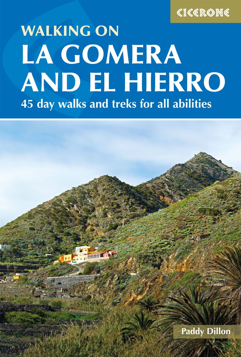
- Walking on La Gomera and El Hierro: 45 day walks and treks for all abilities
- Walking guide to the islands of La Gomera and El Hierro. The 45 waymarked routes in this guidebook include easy strolls and hands-on scrambles, day walks and long-distance routes including the GR132 and parts of the GR131, which runs the whole length of the Canary Islands. Walks are spread in the guide roughly clockwise and where walks are... Read more
- Also available from:
- The Book Depository, United Kingdom
- De Zwerver, Netherlands

United Kingdom
2020
- Walking on La Gomera and El Hierro
- 45 day walks and treks for all abilities Read more


United Kingdom
2018
- La Gomera & Southern Tenerife Sunflower Landscape Guide
- This book is for those staying on La Gomera or in the south of Tenerife (within easy reach of the Gomera ferry). Since the two islands are just a 35-minute ferry ride apart, the book covers walks and tours on both. There are car tours (with picnic suggestions) ranging all over both islands, with pull-out touring maps and plans for the larger... Read more
- Also available from:
- The Book Depository, United Kingdom

United Kingdom
2018
- La Gomera and Southern Tenerife Sunflower Guide
- 70 long and short walks with detailed maps and GPS; 6 car tours with pull-out map Read more

United Kingdom
2019
- Trekking in the Canary Islands: The GR131 island-hopping route
- This guidebook provides a comprehensive and detailed description of the GR131, an island-hopping trail across the seven Canary Islands. The 560km (348 mile) route begins on Lanzarote and finishes on El Hierro and is presented in 32 daily stages. The route is well waymarked but some navigational skills are required, and the remote and occasional... Read more
- Also available from:
- The Book Depository, United Kingdom
- De Zwerver, Netherlands

United Kingdom
2019
- Trekking in the Canary Islands
- The GR131 island-hopping route Read more

Netherlands
2019
- Wandelgids Trekking in the Canary Islands: The GR131 Island Hopping Route | Cicerone
- Guidebook to the GR131, an island-hopping trail that runs coast to coast across each of the 7 Canary Islands, a sub-tropical Spanish archipelago. Described over 32 stages, the route begins on Lanzarote, finishes on El Hierro, measures 560km (348 miles) and would take an average trekker about 1 month to complete. Read more

United Kingdom
2022
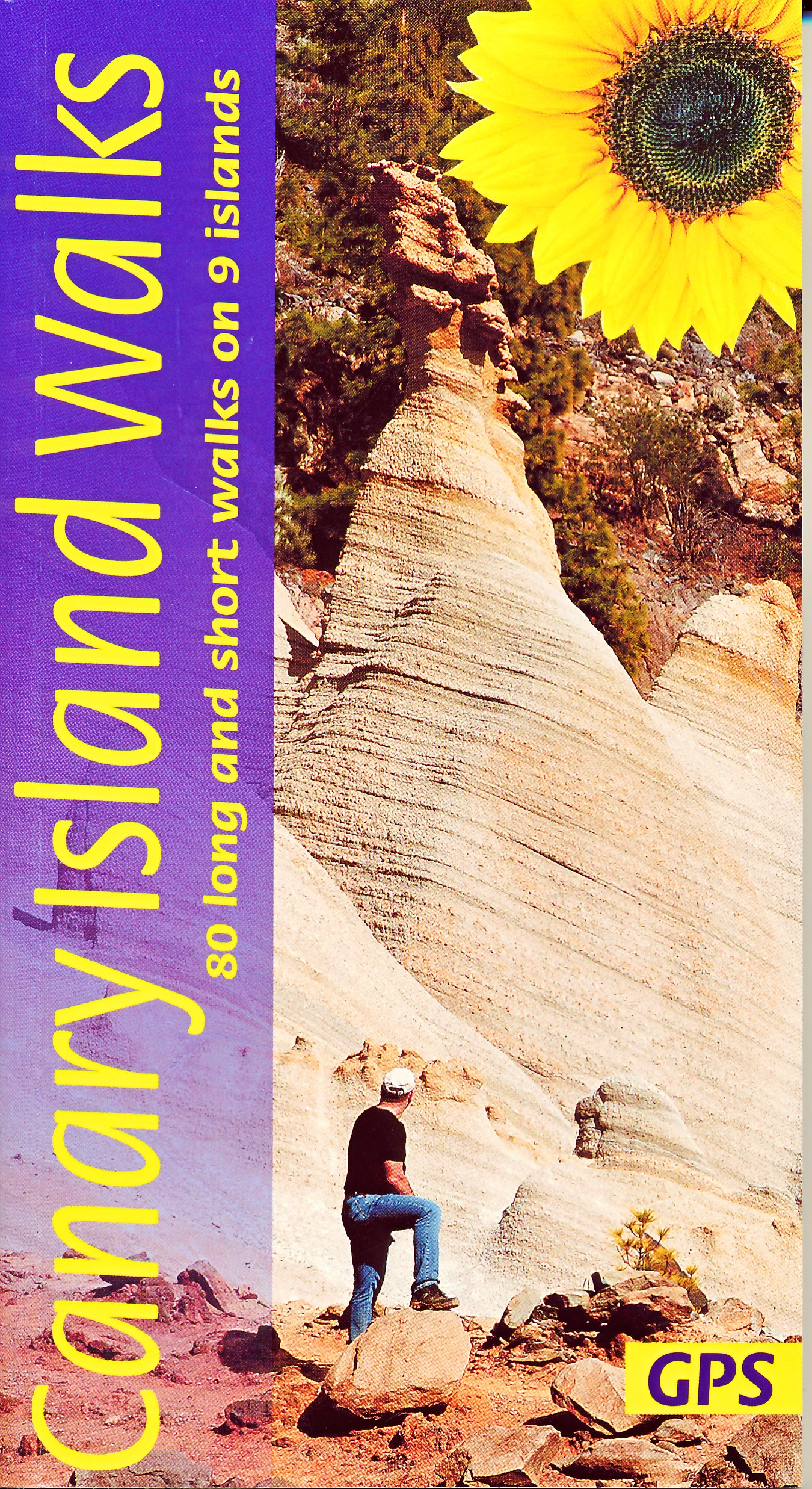
- Canary Islands Walks Sunflower Guide: 90 long and short walks on the Canary Islands
- The go-to travel guide for discovering the best walks on the Canary Islands; Strap on your boots and discover the Canary Islands on foot with the Sunflower Canary Islands Walks travel guide. The Sunflower Canary Islands Walks guide is indispensable for walking and hiking on all 7 Canary Islands - Tenerife, Gran Canaria, Lanzarote,... Read more
- Also available from:
- The Book Depository, United Kingdom
- De Zwerver, Netherlands

United Kingdom
2022
- Canary Islands Walks Sunflower Guide
- 80 long and short walks on the Canary Islands Read more
Netherlands
2022
- Wandelgids Canary Islands Walks | Sunflower books
- The go-to travel guide for discovering the best walks on the Canary Islands; Strap on your boots and discover the Canary Islands on foot with the Sunflower Canary Islands Walks travel guide. The Sunflower Canary Islands Walks guide is indispensable for walking and hiking on all 7 Canary Islands - Tenerife, Gran Canaria, Lanzarote,... Read more

United Kingdom
2019
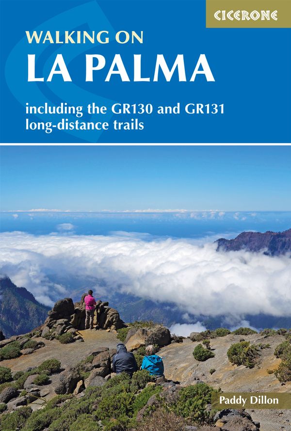
- Walking on La Palma: Including the GR130 and GR131 long-distance trails
- Guide to walking on La Palma. In total 45 day walks are described ranging from 7 to 32km in length, and covering a wide variety of terrain. Although La Palma is one of the smaller Canary Islands, there are routes of all types from easy strolls to hands-on scrambling, from simple day walks to long-distance treks on rocky mountain paths,... Read more
- Also available from:
- The Book Depository, United Kingdom
- De Zwerver, Netherlands

United Kingdom
2019
- Walking on La Palma
- Including the GR130 and GR131 long-distance trails Read more
Netherlands
2019
- Wandelgids Walking on La Palma | Cicerone
- Guidebook to 45 walks and scrambles on La Palma in the Canary Islands, ranging from 7 to 31km. Some walks combine to complete the GR130 long-distance trail (eight days) and GR131 trail (three days). Areas explored include Santa Cruz and Buenavista. Contains a Spanish-English glossary. Read more

United Kingdom
2020
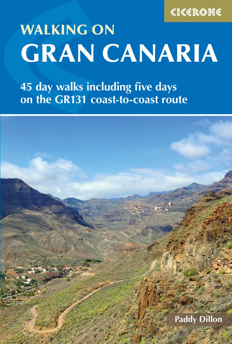
- Walking on Gran Canaria: 45 day walks including five days on the GR131 coast-to-coast route
- The guidebook describes 45 day walks across eight areas of Gran Canaria, including Las Palmas in the north to Playa del Ingles in the south. Also included is a five-day coast-to-coast route on the GR131, an island-hopping long-distance trail stretching across all seven of the Canary Islands. There are walks suitable for those of all abilities,... Read more
- Also available from:
- The Book Depository, United Kingdom
- De Zwerver, Netherlands

United Kingdom
2020
- Walking on Gran Canaria
- 45 day walks including five days on the GR131 coast-to-coast route Read more
Netherlands
2020
- Wandelgids Walking on Gran Canaria | Cicerone
- Guidebook describing 45 day walks on Gran Canaria, generally averaging 10 to 12km each. A long-distance coast-to-coast route on the GR131 is included, and shorter walks can be linked to form longer itineraries. One of the larger Canary Islands, Gran Canaria is a popular destination but offers many peaceful, rural areas perfect for walking. Read more
Maps

United Kingdom
- Lanzarote Kompass 241
- Lanzarote at 1:50,000 on a contoured and GPS compatible map from Kompass, with extensive tourist overprint, plus street plans of Arrecife, Puerto del Carmen and Teguise. Coverage includes the nearby islands of Graciosa, Montaña Clara and Alwegranza.Topography is vividly presented by contours at 50m intervals, enhanced by relief shading plus... Read more

United Kingdom
- Los Cristianos CNIG Topo 1102
- Los Cristianos area of Tenerife, map No. 1102 in the topographic coverage of the Canary Islands at 1:50,000 from the Instituto Geográfico Nacional - Centro Nacional de Información Geograficá, Spain’s civilian survey organization. Maps in the MTN50 (Mapa Topográfico Nacional) series begun in late 1990s have contours at 20m intervals enhanced by... Read more

United Kingdom
- Tegueste CNIG Topo 1088-2
- Topographic coverage of the Canary Islands at 1:25,000 published by the Instituto Geográfico Nacional – Centro Nacional de Información Geografica, the country’s civilian survey organization. The maps have contours at 10m intervals and colouring and/or graphics to show different types of vegetation or land use. Boundaries of national parks and... Read more
United Kingdom
- Granadilla de Abona CNIG Topo 1096-4/1097-3
- Topographic coverage of the Canary Islands at 1:25,000 published by the Instituto Geográfico Nacional – Centro Nacional de Información Geografica, the country’s civilian survey organization. The maps have contours at 10m intervals and colouring and/or graphics to show different types of vegetation or land use. Boundaries of national parks and... Read more
United Kingdom
- Izaña - Tenerife CNIG Topo 1092-3
- Topographic coverage of the Canary Islands at 1:25,000 published by the Instituto Geográfico Nacional – Centro Nacional de Información Geografica, the country’s civilian survey organization. The maps have contours at 10m intervals and colouring and/or graphics to show different types of vegetation or land use. Boundaries of national parks and... Read more
United Kingdom
- Granadilla de Abona CNIG Topo 1097
- Granadilla de Abona area of Tenerife, map No. 1097 in the topographic coverage of the Canary Islands at 1:50,000 from the Instituto Geográfico Nacional - Centro Nacional de Información Geograficá, Spain’s civilian survey organization. Maps in the MTN50 (Mapa Topográfico Nacional) series begun in late 1990s have contours at 20m intervals... Read more
United Kingdom
- Tacoronte - Tenerife CNIG Topo 1088-3/4
- Topographic coverage of the Canary Islands at 1:25,000 published by the Instituto Geográfico Nacional – Centro Nacional de Información Geografica, the country’s civilian survey organization. The maps have contours at 10m intervals and colouring and/or graphics to show different types of vegetation or land use. Boundaries of national parks and... Read more
United Kingdom
- Fasnia CNIG Topo 1097-1/2
- Topographic coverage of the Canary Islands at 1:25,000 published by the Instituto Geográfico Nacional – Centro Nacional de Información Geografica, the country’s civilian survey organization. The maps have contours at 10m intervals and colouring and/or graphics to show different types of vegetation or land use. Boundaries of national parks and... Read more
United Kingdom
- Guimar CNIG Topo 1092-4
- Topographic coverage of the Canary Islands at 1:25,000 published by the Instituto Geográfico Nacional – Centro Nacional de Información Geografica, the country’s civilian survey organization. The maps have contours at 10m intervals and colouring and/or graphics to show different types of vegetation or land use. Boundaries of national parks and... Read more
United Kingdom
- Puerto de la Cruz CNIG Topo 1092
- Puerto de la Cruz area of Tenerife, map No. 1092 in the topographic coverage of the Canary Islands at 1:50,000 from the Instituto Geográfico Nacional - Centro Nacional de Información Geograficá, Spain’s civilian survey organization. Maps in the MTN50 (Mapa Topográfico Nacional) series begun in late 1990s have contours at 20m intervals enhanced... Read more
United Kingdom
- Punta de Anaga CNIG Topographic Map 1089-1
- Topographic coverage of the Canary Islands at 1:25,000 published by the Instituto Geográfico Nacional – Centro Nacional de Información Geografica, the country’s civilian survey organization. The maps have contours at 10m intervals and colouring and/or graphics to show different types of vegetation or land use. Boundaries of national parks and... Read more
United Kingdom
- Arico - Tenerife CNIG Topo 1097-3/4
- Topographic coverage of the Canary Islands at 1:25,000 published by the Instituto Geográfico Nacional – Centro Nacional de Información Geografica, the country’s civilian survey organization. The maps have contours at 10m intervals and colouring and/or graphics to show different types of vegetation or land use. Boundaries of national parks and... Read more
United Kingdom
- Los Cristianos - Tenerife CNIG Topo 1102-1
- Topographic coverage of the Canary Islands at 1:25,000 published by the Instituto Geográfico Nacional – Centro Nacional de Información Geografica, the country’s civilian survey organization. The maps have contours at 10m intervals and colouring and/or graphics to show different types of vegetation or land use. Boundaries of national parks and... Read more
United Kingdom
- Buenavista del Norte - Tenerife CNIG Topo 1091-I
- Topographic coverage of the Canary Islands at 1:25,000 published by the Instituto Geográfico Nacional – Centro Nacional de Información Geografica, the country’s civilian survey organization. The maps have contours at 10m intervals and colouring and/or graphics to show different types of vegetation or land use. Boundaries of national parks and... Read more

United Kingdom
- Gran Canaria
- Gran Canaria, Las Palmas and the island’s main resorts on a clear and informative, waterproof and tear-resistant map from Berndtson, with both the road map and the street plans indexed and highlighting the island’s 15 top rated sites and other places of interest, as well as providing general tourist information. On one side a map at 1:100,000... Read more