E1
Description
- Name E1 (E1)
- Length of trail 7,000 km, 4,350 miles
- Length in days 350 days
- Start of trail North Cape (N)
- End of trail Castellucio (I)
- Traildino grading MW, Moderate walk, backpacking trail
- Hut tour grading T1, Walk

E1
 E1: North Cape (N) - Castellucio (I), 4900+ km.
North Sea – Lake Constance – Gotthard – Mediterranean Sea.
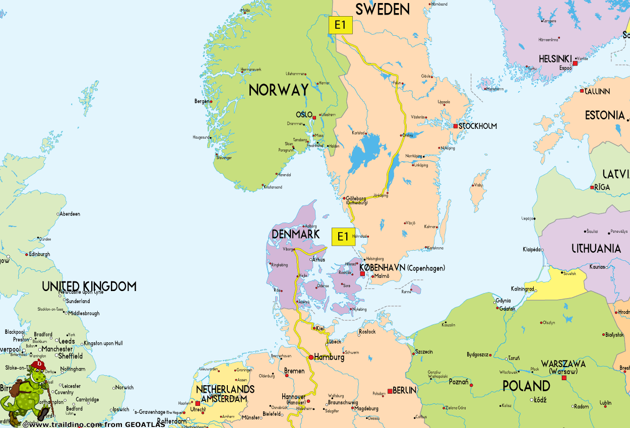
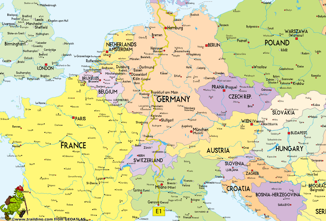
Approximately 7000 km long trail leading from north to south, starting at Grövel Lake in Sweden, through Denmark, Germany and Switzerland to Scapoli in Italy.
Recently, the trail has been extended all the way to the North Cape in Norway! Starting in 2013, the waymarking will be ready.
Norway (2105 km)
Sweden (1200 km)
- Start at Grövelsjön
- Local trails, Grövelsjön - Sälen, 160 km, partly marked
- Vasaloppsleden, Sälen – Mora, 90 km
- Siljansleden, Mora - Leksand, 70 km
- Gagnefs Vandringsleder, Leksand - Gyllbergen (Borlänge municipality), 25 km
- Sméleden, Stora Bråfall at the municipal boundary - Björsjö, 57 km
- Malingsbo-Klotenrundan, southern part: Björsjö - Kloten, 20 km
- Bergslagsleden, Kloten - Karlsborg, 280 km
- Västre Vätterleden, Karlsborg - Mullsjö, 148 km
- Gravelled road, Ryfors - Böne, 20 km
- Redvägsleden, 10 km
- Åsundenleden, small distance
- Sjuhäradsleden, Ulricehamn - Borås, 35 km
- Knalleleden, Borås - Hindås, 45 km
- Vildmarksleden, Hindås - Skatås, not far from central Göteborg, 38 km
- Bohusleden, Göteborg - border Halland / Bohuslän, short distance
- Hallandsleden, to Åkulla, 88 km
- Local trail, Åkulla - Varberg, 21 km
- Last village is Varberg
Denmark (378 km)
Jylland (Jutland):
- Boat from Varberg, Sweden
- Start in Grenå
- Molsruten, Grenå - Risskov, 77 km marked
- Local trails, Risskov - Vrads Sande, 85 km mostly marked
- Hærvejen, Vrads Sande - Rønsdam, 213 km marked (Vrads Sande is about 50 km south of Viborg, the end of the Haervejen)
- Gendarmstien, Rønsdam - Kruså, 3 km marked
Germany (1830 km)
Schleswig-Holstein and Hamburg
- Start in Kupfermühle / Kruså / Flensburg
Eastern route
- Local trails via Kiel, Lübeck, Güster, together with E6
- Local trails from Güster to Hamburg
Western alternative
- Schlei – Eider – Elbe Wanderweg, Flensburg – Hamburg
Niedersachsen, 339 km
- From Hamburg local trails via Buchholz/Nordheide, Soltau to Müden Örtze
- From Müden local trails via Celle, Führberg, Otternhagen, Haste, Springe, Hameln to Bösingfeld
Nordrhein-Westfalen, 276 km
- From Bösingfeld local trails to Horn
- Eggeweg, Horn – Marsberg, 70 km
- From Marsberg local trails via Wirminghausen, Schwalefeld, Altastenburg, Bad Berleburg, Bad Laasphe, Lahnhof, Siegen to Herdorf
Rheinland-Pfalz, 169 km
- From Herdorf local trails via Fuchskaute, Unnau, Selters, Montabaur, Nassau, Balduinstein, Michelbach to Idstein
Hessen, 165,5 km
- From Idstein local trails via Oberursel, Frankfurt-Sachsenhausen, Dreieichenhain, Ober-Ramstadt, Bensheim, Nieder-Liebersbach to Heidelberg
Baden-Württemberg, 464 km
- Westweg, Heidelberg via Titisee, Feldberg to Kappel
- Schwarzwald-Querweg Freiburg–Bodensee, Kappel - Konstanz
- Last city is Konstanz
Switzerland (348 km)
- Entering from Germany at Konstanz (Bodensee)
- Via Jacobi to Vierwaldstättersee;
- Trans-Swiss Trail to Italian border;
- Leaving near Lugano;
Italy
- Alta Via dei Monti Liguri
- Grande Escursione Appenninica
- Plans for extension over Appenine Mountains to Sicily
Select some tracks
☐.European Long distance path E1 - part Germany, Schleswig-Holstein (alternative route Lübeck), 14km
☐.Distance = Länge des hier dargestellten Teils (+ Strecke bis Wendelsplatz in Sachsenhausen), length = Summe der drei Taunus-Abschnitte., 51km
☐.European Long distance path E1 - part Germany, Baden-Wuerttemberg (region Forest of Odes south), 105km
☐.European Long distance path E1 - part Germany, Baden-Wuerttemberg (region Schwarzwald north), 113km
☐.European Long distance path E1 - part Germany, Baden-Wuerttemberg (alternative route Gausbach), 0.8km
☐.European Long distance path E1 - part Germany, Baden-Wuerttemberg (region Schwarzwald centre), 120km
☐.European Long distance path E1 - part Germany, Baden-Wuerttemberg (alternative route Feldberg), 22km
☐.European Long distance path E1 - part Germany, Baden-Wuerttemberg (region Schwarzwald south), 136km
☐European Long distance path E1 - part Germany, Nordrhein-Westfalen (turn-off Bad Driburg), 1.7km
☐Erfttalweg E 1. Etappe, 21km
☐European Long distance path E1 - part Italy - Tuscany, 365km
☐(no name), 6.9km
☐(no name), 2.9km
☐Variante Eremo di Camaldoli, 3km
☐E1 - Berghofen, 4.7km
☐Eijsden-Margraten E1 Natuurgebied Eijsder Beemden, 0.7km
☐E1 Toscana 01 Variante 1.1, 6.5km
☐E1 Toscana 11 Variante 11.1, 0.8km
☐Sensotorik Runde, 10km
☐Kurweg Kreischa e1, 1.7km
☐Erflinghausen 1, 7.7km
☐Monte Proratado - Sentiero E1 (AVML), 0.4km
☐Eschelhof - Hörschbachtour, 13km
☐E1 Ormos Giannaki-Kardiani-Ysternia-Ormos Ysternion-Ormos Giannaki, 14km
☐European Long distance path E1 - part Italy - Campania, 3km
☐(no name), 3.6km
☐Wanderparkplatz Bechener Esel Rundweg E1, 10km
☐Orketal Wanderweg E1, 6km
☐Sentiero europeo E1 - Variante di Pegli, 26km
☐Grand circuit des gorges de la Vienne, 13km
☐Variante - Grand circuit des gorges de la Vienne, 2.9km
☐GR 35 E01 Altxonbide ibilbidea: Zarautz - Bidegoian, 23km
☐GR 286 E1 Araindarri Hiru tenpluen ibilbidea: Zumaia - Loiola, 25km
Map
Links
Facts
Reports
Guides and maps
Lodging
Organisations
Tour operators
GPS
Other
Books

De Zwerver
Netherlands
2017
Netherlands
2017
- Wandelgids 411 Kautokeino - Nordkap E1 | Conrad Stein Verlag
- Handzaam boekje met de routebeschrijving inclusief een heleboel praktische informatie. De beschrijving is uitstekend, maar kaarten zijn wat beperkt. Duits. Die 330 km lange Wanderung auf dem E1 von Kautokeino zum Nordkap ist ein unvergessliches Wanderabenteuer. In 15 Etappen laufen Sie durch die Wildnis Nordnorwegens und überqueren die... Read more
More books…
Maps

Stanfords
United Kingdom
United Kingdom
- Alpe della Luna 17
- Map No. 16, Monte Carpegna - Sasso di Simone, in series of contoured, GPS compatible hiking maps at 1:25,000 from the Istituto Geografico Adriatico, covering mainly the spine of the Apennines along the borders of Tuscany, Emilia-Romagna, Umbria and the Marches.Map in this series have contours at 25m intervals with additional shading and... Read more

Stanfords
United Kingdom
United Kingdom
- Alta Valle del Lamone 22
- Map No. 22, Alta Valle del Lamone: Alto Appennino Faentino – Anello di Marradi, in series of contoured, GPS compatible hiking maps at 1:25,000 from the Istituto Geografico Adriatico, covering mainly the spine of the Apennines along the borders of Tuscany, Emilia-Romagna, Umbria and the Marches.Map in this series have contours at 25m intervals... Read more

Stanfords
United Kingdom
United Kingdom
- Appennino Tosco-Romagnolo East
- Map No. 135, Appennino Tosco-Romagnolo East, in a series of GPS compatible hiking maps at 1:50,000 from the Istituto Geografico Adriatico, covering parts of central Italy: eastern Tuscany, with northern Umbria and the Marches, plus the south-eastern of part of Emilia-Romagna.The maps have contours at 50m intervals with additional shading and... Read more

Stanfords
United Kingdom
United Kingdom
- Alta Valle del Santerno 23
- Map No. 22, Alta Valle del Lamone: Alto Appennino Faentino – Anello di Marradi, in series of contoured, GPS compatible hiking maps at 1:25,000 from the Istituto Geografico Adriatico, covering mainly the spine of the Apennines along the borders of Tuscany, Emilia-Romagna, Umbria and the Marches.Map in this series have contours at 25m intervals... Read more

Stanfords
United Kingdom
United Kingdom
- Alta Val Tiberina
- Map No. 125, Alta Val Tiberina, in a series of GPS compatible hiking maps at 1:50,000 from the Istituto Geografico Adriatico, covering parts of central Italy: eastern Tuscany, with northern Umbria and the Marches, plus the south-eastern of part of Emilia-Romagna.The maps have contours at 50m intervals with additional shading and numerous spot... Read more

Stanfords
United Kingdom
United Kingdom
- Colline di Forlí
- Map No. 127, Colline di Forlí, in a series of GPS compatible hiking maps at 1:50,000 from the Istituto Geografico Adriatico, covering parts of central Italy: eastern Tuscany, with northern Umbria and the Marches, plus the south-eastern of part of Emilia-Romagna.The maps have contours at 50m intervals with additional shading and numerous spot... Read more

Stanfords
United Kingdom
United Kingdom
- Riviera Cesenate - San Marino
- Map No. 128, Riviera Cesenate - San Marino, in a series of GPS compatible hiking maps at 1:50,000 from the Istituto Geografico Adriatico, covering parts of central Italy: eastern Tuscany, with northern Umbria and the Marches, plus the south-eastern of part of Emilia-Romagna.The maps have contours at 50m intervals with additional shading and... Read more

Stanfords
United Kingdom
United Kingdom
- Monte Fumaiolo - Monte Comero 18
- Map No. 18, Monte Fumaiolo - Alto Tevere, in series of contoured, GPS compatible hiking maps at 1:25,000 from the Istituto Geografico Adriatico, covering mainly the spine of the Apennines along the borders of Tuscany, Emilia-Romagna, Umbria and the Marches.Map in this series have contours at 25m intervals with additional shading and numerous... Read more

Stanfords
United Kingdom
United Kingdom
- Alta Val Marecchia
- Map No. 126, Alta Val Marecchia, in a series of GPS compatible hiking maps at 1:50,000 from the Istituto Geografico Adriatico, covering parts of central Italy: eastern Tuscany, with northern Umbria and the Marches, plus the south-eastern of part of Emilia-Romagna.The maps have contours at 50m intervals with additional shading and numerous spot... Read more

Stanfords
United Kingdom
United Kingdom
- Bagno di Romagna Monti Editore 19
- Map No. 19, Bagno di Romagna, in series of contoured, GPS compatible hiking maps at 1:25,000 from the Istituto Geografico Adriatico, covering mainly the spine of the Apennines along the borders of Tuscany, Emilia-Romagna, Umbria and the Marches.The maps have contours at 25m intervals with additional shading and numerous Map in this series have... Read more

Stanfords
United Kingdom
United Kingdom
- Alta Valle del Metauro: Valle del Candigliano, Monte Nerone, Monte Catria
- Map No. 122, Alta Valle del Metauro: Valle del Candigliano, Monte Nerone, Monte Catria, in a series of GPS compatible hiking maps at 1:50,000 from the Istituto Geografico Adriatico, covering parts of central Italy: eastern Tuscany, with northern Umbria and the Marches, plus the south-eastern of part of Emilia-Romagna.The maps have contours at... Read more

Stanfords
United Kingdom
United Kingdom
- Monte Carpegna - Sasso di Simone
- Map No. 16, Monte Carpegna - Sasso di Simone, in series of contoured, GPS compatible hiking maps at 1:25,000 from the Istituto Geografico Adriatico, covering mainly the spine of the Apennines along the borders of Tuscany, Emilia-Romagna, Umbria and the Marches.Map in this series have contours at 25m intervals with additional shading and... Read more

Stanfords
United Kingdom
United Kingdom
- Monti Sibillini National Park Edizioni Multigraphic 60/61
- Monti Sibillini National Park at 1:25,000 on a double-sided contoured map from Edizioni Multigraphic highlighting local waymarked hiking routes including the GAS – Grand Anello dei Sibilini, the circular tour around the mountains.The map has contours at 25m intervals with colouring for woodlands. Waymarked routes are highlighted and annotated... Read more

Stanfords
United Kingdom
United Kingdom
- Foreste Casentinesi NP Monti Editore 20
- Map No. 20, Foreste Casentinesi: Campigna, Camaldoli, Chiusi dell Verna, in series of contoured, GPS compatible hiking maps at 1:25,000 from the Istituto Geografico Adriatico, covering mainly the spine of the Apennines along the borders of Tuscany, Emilia-Romagna, Umbria and the Marches.Map in this series have contours at 25m intervals with... Read more

Stanfords
United Kingdom
United Kingdom
- Alpe di San Benedetto 21
- Map No. 21, Alpe di San Benedetto: Passo del Muraglione – San Godenzo – Dicomano, in series of contoured, GPS compatible hiking maps at 1:25,000 from the Istituto Geografico Adriatico, covering mainly the spine of the Apennines along the borders of Tuscany, Emilia-Romagna, Umbria and the Marches.Map in this series have contours at 25m intervals... Read more


